 view gallery view gallery N12.4 km N12.4 km
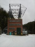
|   McKay Station - Piscataquis County, Maine, USA McKay Station - Piscataquis County, Maine, USA
in Hydroelectric Power Stations McKay Station is a hydroelectric power station located on the West Branch of the Penobscot River. It is located approximately 3000 feet down stream from Ripogenus Dam. posted by:  UMainah UMainah location: Maine date approved: 08/29/2012 last visited: 04/08/2012 |
 view gallery view gallery NE20.3 km NE20.3 km
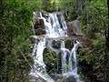
|  Katahdin Stream Falls - Baxter State Park, ME Katahdin Stream Falls - Baxter State Park, ME
in Waterfalls Picturesque waterfall along the Appalachian Trail at the foot of Mount Katahdin in Baxter State Park in Maine. posted by:  hykesj hykesj location: Maine date approved: 01/12/2024 last visited: never |
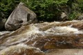 view gallery view galleryN23.2 km |  K81 - Ledge Falls - Nesowadnehunk Stream K81 - Ledge Falls - Nesowadnehunk Stream
in U.S. Benchmarks Ledge Falls - Nesowadnehunk Stream posted by: Marbuel location: Maine date approved: 08/04/2009 last visited: 08/01/2009 |
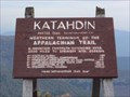
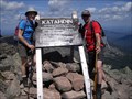
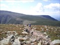
 view gallery view galleryNE24.5 km |  Mount Katahdin - Northern Terminus Appalachian Trail Mount Katahdin - Northern Terminus Appalachian Trail
in Appalachian Trail Mount Katahdin is the northern terminus of the Appalachian Trail. posted by: hyperheidi location: Maine date approved: 10/02/2011 last visited: 06/25/2019 |
 view gallery view galleryNE24.5 km |  Mount Katahdin - Maine Mount Katahdin - Maine
in Wikipedia Entries Mount Katahdin (USGS name) is the highest mountain in Maine. Called Katahdin by people local to the peak and by the Penobscot Indians: the term means "The Greatest Mountain". It is located in east central Piscataquis County about 25 miles (40 km) northwest of Millinocket. It divides the East and West Branches of the Penobscot River. From the low lake country to the south and east, the mountain appears to be one of the tallest and most abrupt in the Appalachian Mountains.
posted by: CM-14 location: Maine date approved: 08/21/2007 last visited: 06/25/2019 |
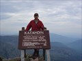
 view gallery view galleryNE24.5 km |  Mt. Katahdin (Baxter Peak) - Maine (5267 FEET) Mt. Katahdin (Baxter Peak) - Maine (5267 FEET)
in Elevation Signs Located in Baxter State Park and accessible by several trails including the Appalachian Trail. posted by: CM-14 location: Maine date approved: 08/23/2007 last visited: 06/25/2019 |
 view gallery view galleryNE24.5 km |  The Highest Point in Maine - Maine, USA The Highest Point in Maine - Maine, USA
in Geographic High Points The Highest Point in Maine is located on Baxter Peak, Maine, USA. posted by: tatie location: Maine date approved: 05/01/2012 last visited: 08/15/2023 |
 view gallery view galleryNE24.5 km |  Mt Katahdin Mt Katahdin
in Mountain Summits The northern terminus of the Appalachin Trail located in Baxter State Park posted by: Katahdinbound location: Maine date approved: 09/07/2005 last visited: 06/25/2019 |
 view gallery view galleryNE24.5 km | Baxter Peak Cairn in U.S. Benchmarks Rock cairn on top of Baxter Peak posted by: A Bound Crew location: Maine date approved: 08/06/2008 last visited: 06/25/2019 |
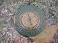 view gallery view galleryNE24.5 km | Katahdin Reference Marker # 1 in U.S. Benchmarks Baxter Peak Cairn Reference Marker # 1 posted by: A Bound Crew location: Maine date approved: 08/06/2008 last visited: 06/25/2019 |
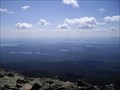 view gallery view galleryNE29.3 km |  Mount Katahdin - Maine, USA Mount Katahdin - Maine, USA
in Scenic Overlooks Mount Katahdin (USGS name) is the highest mountain in Maine. posted by: tatie location: Maine date approved: 04/15/2012 last visited: 06/25/2019 |
 view gallery view galleryNE29.3 km | Katahdin Grand Tour - Maine, USA in Scenic Hikes Mount Katahdin (USGS name) is the highest mountain in Maine. posted by: tatie location: Maine date approved: 04/04/2012 last visited: 06/25/2019 |
 view gallery view gallery SW33.8 km SW33.8 km
|  B-52 Crash Site B-52 Crash Site
in Plane Crash Sites B-52 Crash site near Greenville, Maine
posted by: Smitty & Co. location: Maine date approved: 09/13/2005 last visited: 08/14/2015 |
 view gallery view gallery S35.6 km S35.6 km
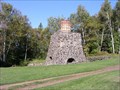
|  Katahdin Iron Works Katahdin Iron Works
in Iron Furnace Ruins Built in the 1800's posted by: Haffy location: Maine date approved: 10/02/2005 last visited: 10/11/2009 |
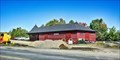 view gallery view gallerySW48.9 km | Canadian Pacific Railway Depot (Greenville Junction, Maine) - Greenville Junction, ME in Wikipedia Entries The Greenville Junction Depot is a historic railway station at Greenville Junction, Maine. The wood frame, one-story building was opened in 1889 with an addition made in 1911. posted by: nomadwillie location: Maine date approved: 01/07/2023 last visited: never |
 view gallery view gallerySW48.9 km |  Greenville Junction Railroad Depot - Greenville Junction, ME Greenville Junction Railroad Depot - Greenville Junction, ME
in Train Stations/Depots The Greenville Junction Depot is a historic railway station at Greenville Junction, Maine. The wood frame, one-story building was opened in 1889 with an addition made in 1911. posted by: nomadwillie location: Maine date approved: 01/12/2023 last visited: never |
 view gallery view gallery E54.1 km E54.1 km
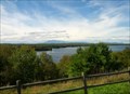
|  A.J. "Allie" Cole Scenic Overlook - Benedicta, Maine A.J. "Allie" Cole Scenic Overlook - Benedicta, Maine
in Scenic Roadside Look-Outs This scenic overlook is located along I-95 at Mile Marker 252. It has great view of Mount Katahdin with Salmon Stream Lake in the foreground. It is accessible from the Northbound side of the Interstate only. posted by: UMainah location: Maine date approved: 04/19/2014 last visited: 06/20/2021 |
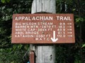 view gallery view gallerySW56.3 km | 100 Mile Wilderness in Appalachian Trail AT 100 mile wilderness sign posted by: Haffy location: Maine date approved: 08/30/2005 last visited: 08/22/2013 |
 view gallery view gallerySW59.4 km |  Spring Creek Bar-B-Q - Monson ME Spring Creek Bar-B-Q - Monson ME
in Classic BBQ and Sandwich Joints Located on Rt 15 in uptown Monson in the last town on the Appalachian Trail. posted by: nomadwillie location: Maine date approved: 06/13/2013 last visited: 08/24/2013 |
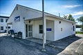 view gallery view gallerySW59.4 km |  Monson, ME 04464 Monson, ME 04464
in U.S. Post Offices The post office in located at 2 Greenville Rd, Monson, ME posted by: nomadwillie location: Maine date approved: 01/08/2023 last visited: never |
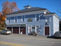 view gallery view gallerySW59.4 km |  Monson Historical Society - Monson, Maine Monson Historical Society - Monson, Maine
in Historical Society Headquarters The Monson Historical Society is a repository of objects, photographs, publications and archives depicting the local history and culture for the town of Monson and surrounding towns of Blanchard, Willimantic and Elliotsville. posted by: ME-Packrats location: Maine date approved: 10/22/2017 last visited: never |
 view gallery view gallerySW59.5 km |  Swedish Lutheran Church - Monson, ME Swedish Lutheran Church - Monson, ME
in U.S. National Register of Historic Places The Swedish Lutheran Church (also known as the Old Church Hostel) is a historic former Swedish Lutheran church building. The church was established by Swedish immigrants to Maine and built by them in 1890. posted by: nomadwillie location: Maine date approved: 01/08/2023 last visited: never |
 view gallery view gallerySW59.5 km |  AIIA Institute ~ Swedish Lutheran Church - Monson, ME AIIA Institute ~ Swedish Lutheran Church - Monson, ME
in This Old Church The Swedish Lutheran Church (also known as the Old Church Hostel) is a historic former Swedish Lutheran church building. The church was established by Swedish immigrants to Maine and built by them in 1890. posted by: nomadwillie location: Maine date approved: 01/07/2023 last visited: never |
 view gallery view gallerySW59.5 km | Swedish Lutheran Church (Monson, Maine) in Wikipedia Entries The Swedish Lutheran Church (also known as the Old Church Hostel) is a historic former Swedish Lutheran church building. The church was established by Swedish immigrants to Maine and built by them in 1890. posted by: nomadwillie location: Maine date approved: 01/07/2023 last visited: never |
 view gallery view galleryE62.3 km |  Mary Cobb Grave Mary Cobb Grave
in Abandoned Cemeteries Mary Cobb is also a geocaching site. The gravesite is where an stage coach stopped. Mary Cobb and her infant died here. posted by: Laker121 location: Maine date approved: 08/26/2009 last visited: 11/09/2010 |
|