 view gallery view gallery NW33.5 km NW33.5 km
|   Mississagi Lighthouse Mississagi Lighthouse
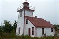
in Coastal Lighthouses The Mississagi Lighthouse on Manatoulin Island on Lake Huron near Meldrum Bay. posted by:  Avernar Avernar location: Ontario, Canada date approved: 08/29/2008 last visited: 06/25/2011 |
 view gallery view gallery NE50.1 km NE50.1 km
|  Harold Noble Memorial Lookout - Gore Bay, Ontario Harold Noble Memorial Lookout - Gore Bay, Ontario
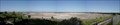
in Scenic Roadside Look-Outs The Harold Noble Memorial Lookout lookout offers a beautiful view over Gore Bay and to the town of Gore Bay. This photo is from November - it would be great to capture what it looks like in other times of the year. posted by: Trail Blaisers location: Ontario, Canada date approved: 12/01/2013 last visited: 05/23/2005 |
 view gallery view gallery SW52.5 km SW52.5 km
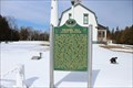
|  Presque Isle Light Station Presque Isle Light Station
in Michigan Historical Markers 4500 East Grand Lake Rd -- drive north until the road ends posted by:  Historic Markers Historic Markers location: Michigan date approved: 03/19/2018 last visited: 12/26/2021 |
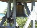 view gallery view gallerySW52.5 km |  Old Lansing City Hall Bell - Presque Isle, Michigan Old Lansing City Hall Bell - Presque Isle, Michigan
in Bells Located at the old Presque Isle Lighthouse, on Grand Lake Road. The great thing is that you can ring it. But you need to cover your ears right away. Trust me. posted by: S5280ft location: Michigan date approved: 10/18/2007 last visited: 07/31/2020 |
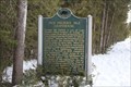 view gallery view gallerySW52.8 km | Old Presque Isle Lighthouse in Michigan Historical Markers Coordinates are where the marker is. The lighthouse appears to be accessible by a seasonal road or walk only.
Definitely one of the weirder locations for a marker.. posted by: Historic Markers location: Michigan date approved: 03/19/2018 last visited: 12/26/2021 |
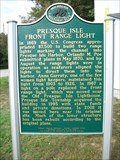 view gallery view gallerySW53.6 km | Presque Isle Front Range Light in Michigan Historical Markers Presque Isle Front Range Light posted by: just for the fun location: Michigan date approved: 10/15/2016 last visited: 12/26/2021 |
 view gallery view gallerySW53.9 km | Burnham's Landing in Michigan Historical Markers A nice little park with the marker posted by: Historic Markers location: Michigan date approved: 03/19/2018 last visited: 03/14/2018 |
 view gallery view gallerySW55.4 km | John Kauffman House in Michigan Historical Markers 7993 East Grand Lake Rd in Grand Lake
Street parking posted by: Historic Markers location: Michigan date approved: 03/19/2018 last visited: 09/21/2023 |
 view gallery view gallerySW55.5 km | Presque Isle Lodge in Michigan Historical Markers 8211 East Grand Lake Rd in Presque Isle
Street parking posted by: Historic Markers location: Michigan date approved: 03/19/2018 last visited: 09/21/2023 |
 view gallery view gallery N59.5 km N59.5 km
|  Tim Horton's - Causley St., Blind River Tim Horton's - Causley St., Blind River
in Tim Horton's Restaurants This location on the North side of Causley Street. posted by: Lakeport location: Ontario, Canada date approved: 08/19/2007 last visited: 01/13/2021 |
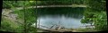 view gallery view gallerySW59.7 km |  Rockport Sink Holes Rockport Sink Holes
in Natural Sinkholes A group of over a dozen sink holes, some containing water. Access is limited to foot travel, the closest parking is near the Rockport boat launch. posted by: theinerr location: Michigan date approved: 06/19/2009 last visited: 07/25/2010 |
 view gallery view galleryN60.2 km |  Blind River, Ontario - High Rock Hill Triangulation Point Blind River, Ontario - High Rock Hill Triangulation Point
in Canadian Benchmarks Iron spike atop High Rock Hill in Blind River posted by: Juicepig location: Ontario, Canada date approved: 05/14/2010 last visited: 05/11/2010 |
 view gallery view galleryNE61.8 km |  Millstone - Kagawong, Ontario Millstone - Kagawong, Ontario
in Millstones A late 19th century millstone located in the parking area for Bridal Veil Falls. posted by: Trail Blaisers location: Ontario, Canada date approved: 12/01/2013 last visited: 09/07/2022 |
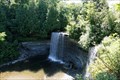 view gallery view galleryNE61.8 km |  Bridal Veil Falls - Kagawong, Ontario Bridal Veil Falls - Kagawong, Ontario
in Waterfalls Bridal Veil Falls is located in the village of Kagawong on Manatoulin Island. posted by: Avernar location: Ontario, Canada date approved: 09/18/2008 last visited: 09/07/2022 |
 view gallery view galleryNE62.1 km |  OHP - "KAGAWONG MILL -1925-" OHP - "KAGAWONG MILL -1925-"
in Ontario Provincial Plaques A spot near a very nice beach and a very good chocolate shop. posted by: bwmick location: Ontario, Canada date approved: 08/09/2006 last visited: 02/10/2014 |
 view gallery view gallery E65.8 km E65.8 km
|  M'Chigeeng First Nation - Manitoulin Island, Ontario M'Chigeeng First Nation - Manitoulin Island, Ontario
in Nations Within Nations M'Chigeeng First Nation is an Ojibwe First Nation in the Manitoulin District. posted by: Trail Blaisers location: Ontario, Canada date approved: 12/01/2013 last visited: never |
 view gallery view gallery W69.5 km W69.5 km
| World's Largest Limestone Quarry in Michigan Historical Markers Follow the coordinates to the booth and turn right, there's an exit road just for this.. posted by: Historic Markers location: Michigan date approved: 03/19/2018 last visited: 09/21/2023 |
 view gallery view gallerySW71.1 km |  Oglebay Norton Calcite Quarry - Rogers City, Michigan Oglebay Norton Calcite Quarry - Rogers City, Michigan
in Active Quarries This waymark is at an overlook on Quarry Road, east of Petersville Road. The main plant entrance (where the historical marker is located) is at N45 24.666 W83 47.487. This quarry is about 3.75 miles E/W by 3 miles N/S. posted by: S5280ft location: Michigan date approved: 10/29/2007 last visited: 09/09/2011 |
 view gallery view gallerySW71.6 km | Presque Isle Electric Cooperative Monument in Michigan Historical Markers 10957 Michigan Street in downtown Posen.
Park on the street. posted by: Historic Markers location: Michigan date approved: 03/19/2018 last visited: 03/14/2018 |
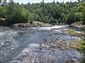 view gallery view galleryNE71.6 km | Kennebec Falls - Algoma Mills, ON in Waterfalls Beautiful cascading waterfall located on the Serpent River in Northern Ontario. posted by: jiggs11 location: Ontario, Canada date approved: 09/05/2020 last visited: 09/08/2022 |
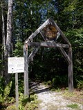 view gallery view galleryNE71.6 km |  Kennebec Falls Trailhead - Algoma Mills, ON Kennebec Falls Trailhead - Algoma Mills, ON
in Hiking and walking trailheads Trailhead for the beautiful Kennebec Falls trail. posted by: jiggs11 location: Ontario, Canada date approved: 09/20/2020 last visited: 09/08/2022 |
 view gallery view gallerySW73.4 km | World's Largest Cement Plant in Michigan Historical Markers Located on Ford Road across from Wessell posted by: Historic Markers location: Michigan date approved: 04/29/2015 last visited: 12/10/2021 |
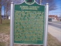 view gallery view gallerySW74.5 km | Alpena County Courthouse in Michigan Historical Markers Located on Crisholm between 8 and 9th streets. posted by: Historic Markers location: Michigan date approved: 04/29/2015 last visited: 11/04/2021 |
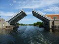 view gallery view gallerySW74.7 km |  2nd Avenue Bridge - Alpena, Michigan 2nd Avenue Bridge - Alpena, Michigan
in Moving Bridges 2nd avenue bridge spans the Thunder Bay River posted by: Treknschmidt location: Michigan date approved: 11/02/2013 last visited: 10/06/2016 |
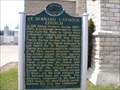 view gallery view gallerySW74.7 km | St. Bernard Catholic Church in Michigan Historical Markers Located on Chriholm and 4th Ave posted by: Historic Markers location: Michigan date approved: 04/29/2015 last visited: 11/04/2021 |
|