 view gallery view gallery E0.6 km E0.6 km
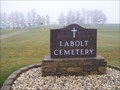
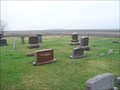
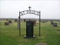
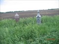
|   LaBolt Cemetery, LaBolt, South Dakota LaBolt Cemetery, LaBolt, South Dakota
in Worldwide Cemeteries Located about a half mile east of town. levatiion 1351 posted by:  NGComets NGComets location: South Dakota date approved: 04/25/2017 last visited: never |
 view gallery view gallery NW1 km NW1 km
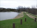
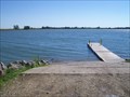
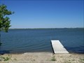
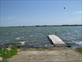
|  LaBolt Dam, LaBolt, South Dakota, USA LaBolt Dam, LaBolt, South Dakota, USA
in Water Dams Built in 1935, this dam created a small lake on the edge of LaBolt, SD. It is owned by South Dakota Game, Fish, and Parks.
Elevation 1389 posted by: NGComets location: South Dakota date approved: 06/13/2017 last visited: never |
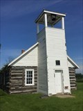
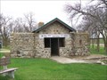 view gallery view galleryNW1.1 km |  LaBolt Bathhouse, WPA Project, LaBolt, South Dakota LaBolt Bathhouse, WPA Project, LaBolt, South Dakota
in WPA Projects A stone building located along LaBolt Lake.
Elevation 1372 posted by: NGComets location: South Dakota date approved: 06/21/2017 last visited: never |
 view gallery view gallery W6.6 km W6.6 km
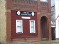
|  "American Legion Post 171" Strandburg, South Dakota "American Legion Post 171" Strandburg, South Dakota
in Legion Posts and Branches Small post in the small town of Strandburg, SD, named for Grant County. posted by: NGComets location: South Dakota date approved: 06/09/2009 last visited: never |
 view gallery view gallery NE6.6 km NE6.6 km
| West Vernon Cemetery, Grant County, South Dakota in Worldwide Cemeteries A small cemetery just west of the intersection of 159th St and 480th Ave.
Elevation 1194 posted by: NGComets location: South Dakota date approved: 04/26/2017 last visited: never |
 view gallery view gallery SE8.7 km SE8.7 km
| Revillo Cemetery, Revillo, South Dakota in Worldwide Cemeteries This cemetery is located southwest of Revillo, SD, and adjacent to the Catholic cemetery. posted by: NGComets location: South Dakota date approved: 06/20/2017 last visited: never |
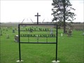 view gallery view gallerySE8.9 km | St. Mary Catholic Cemetery, Revillo, South Dakota in Worldwide Cemeteries This cemetery is just south of the community cemetery southwest of Revillo, SD.
Elevation 1220 posted by: NGComets location: South Dakota date approved: 06/21/2017 last visited: never |
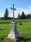 view gallery view gallerySE8.9 km |  A.B. Conrad - Revillo, S.D. A.B. Conrad - Revillo, S.D.
in Zinc Headstones "White bronze" marker in Revillo, South Dakota. posted by: msrubble location: South Dakota date approved: 02/06/2022 last visited: never |
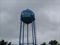 view gallery view gallerySE8.9 km |  Watertower, Revillo, South Dakota Watertower, Revillo, South Dakota
in Water Towers Small town watertower. posted by: NGComets location: South Dakota date approved: 06/09/2009 last visited: never |
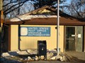
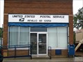 view gallery view gallerySE9.2 km |  Revillo, South Dakota 57259 Revillo, South Dakota 57259
in U.S. Post Offices Small town post office. posted by: NGComets location: South Dakota date approved: 06/09/2009 last visited: never |
 view gallery view galleryNW9.2 km |  Brown Earth Indian Church Brown Earth Indian Church
in South Dakota Historical Markers A roadside plaque commemorating the first church in Grant County. The plaque is located along Highway 20 at 472 Ave; the Church and cemetery are located 1 mile north on 472 Ave and 1/2 mile west on a gravel road at N 45 07.329 W 96 46.319. posted by: farmkid location: South Dakota date approved: 03/14/2007 last visited: 09/14/2019 |
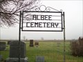 view gallery view galleryE9.3 km | Albee Cemetery, Albee, South Dakota in Worldwide Cemeteries Not quite a mile north of Albee, South Dakota
Elevation 1170 posted by: NGComets location: South Dakota date approved: 04/25/2017 last visited: 10/17/2021 |
 view gallery view galleryE9.5 km | St. Paul Lutheran Cemetery, Albee, South Dakota in Worldwide Cemeteries Located just a mile or so north of Albee, SD.
Elevation 1163 posted by: NGComets location: South Dakota date approved: 04/25/2017 last visited: 09/07/2021 |
 view gallery view galleryE9.7 km | Recaboth Lutheran Cemetery, Revillo, South Dakota in Worldwide Cemeteries A small cemetery north of Revillo, SD. Elevation 1187. posted by: NGComets location: South Dakota date approved: 06/02/2017 last visited: 09/07/2021 |
 view gallery view gallery SW10.6 km SW10.6 km
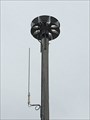
|  New Outdoor Warning Siren - Watson, MN, USA New Outdoor Warning Siren - Watson, MN, USA
in Outdoor Warning Sirens This siren is south of Main Ave., just off of 3rd St. N. posted by: m&m O location: Minnesota date approved: 06/16/2017 last visited: never |
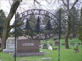
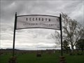
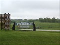 view gallery view galleryNW10.9 km |  Stockholm, South Dakota Stockholm, South Dakota
in Small Town, Big Name Stockholm, South Dakota - Stockholm, Sweden
.
.
.
Population: 94 vs 814,418 posted by: NGComets location: South Dakota date approved: 06/09/2009 last visited: never |
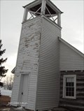
 view gallery view galleryNW10.9 km |  Old Indian Church - SD Old Indian Church - SD
in Country Churches The Old Indian Church was once called the Brown Earth Church and was built in 1877 by a faction of Sisseton-Whapeton Tribes. posted by: MNSearchers location: South Dakota date approved: 06/07/2006 last visited: 09/14/2019 |
 view gallery view galleryNW11.3 km | Stockholm, South Dakota 57264 in U.S. Post Offices Small town post office. posted by: NGComets location: South Dakota date approved: 04/22/2009 last visited: never |
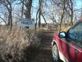 view gallery view gallery S14.3 km S14.3 km
| Walk by still waters and be renewed in South Dakota Historical Markers Single pioneer grave in former homestead garden posted by: plainsdrifter358 location: South Dakota date approved: 12/21/2006 last visited: 07/08/2015 |
 view gallery view galleryW14.5 km | Troy Cemetery, Troy, South Dakota in Worldwide Cemeteries Small, well kept cemetery. Elevation 1930 posted by: NGComets location: South Dakota date approved: 05/01/2014 last visited: never |
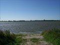
 view gallery view gallerySW15.1 km |  Bullhead Lake, Deuel County, South Dakota Bullhead Lake, Deuel County, South Dakota
in Natural Lakes One of three close lakes in northeast Deuel County, South Dakota.
Elevation 1877 posted by: NGComets location: South Dakota date approved: 09/09/2016 last visited: never |
 view gallery view gallerySW15.1 km | Round Lake, Deuel County, South Dakota in Natural Lakes Located north of Goodwin, SD.
Elevation 1874 posted by: NGComets location: South Dakota date approved: 08/25/2016 last visited: never |
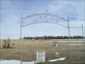
 view gallery view galleryNE15.8 km |  Unnamed Alban Township Cemetery Milbank SD Unnamed Alban Township Cemetery Milbank SD
in Abandoned Cemeteries Unnamed cemetery found in Alban Township, Grant County south of Milbank SD. posted by: MNSearchers location: South Dakota date approved: 08/17/2006 last visited: 06/03/2006 |
 view gallery view gallerySW16.3 km | School Lake, Deuel County, South Dakota in Natural Lakes Small lake in northwest Deuel County, South Dakota.
Elevation 1871 posted by: NGComets location: South Dakota date approved: 09/09/2016 last visited: never |
 view gallery view galleryS18 km | Lake Alice, Deuel County, South Dakota in Natural Lakes Located just a couple miles east of the junction of US 212 and SD Hwy 15. Elevation 1695 posted by: NGComets location: South Dakota date approved: 07/22/2016 last visited: never |
|