 view gallery view gallery W2.3 km W2.3 km
|   Portobello Highway Webcam - Dartmouth, NS Portobello Highway Webcam - Dartmouth, NS
in Web Cameras The province of Nova Scotia operates a network of highway webcams throughout the province to aid motorists in assessing road conditions. posted by:  T0SHEA T0SHEA location: Nova Scotia, Canada date approved: 04/15/2015 last visited: never |
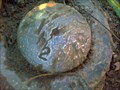
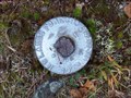 view gallery view galleryW5.1 km |  NS Lands & Forest Marker CPN 0.7A NS Lands & Forest Marker CPN 0.7A
in Canadian Benchmarks Nova Scotia Lands and Forest Survey Marker posted by: pdiamond location: Nova Scotia, Canada date approved: 10/07/2010 last visited: never |
 view gallery view gallery S5.5 km S5.5 km
|  Shubie Park Entrance - Dartmouth, NS Shubie Park Entrance - Dartmouth, NS
in 'You Are Here' Maps This is the first UR Here Map one will encounter on arriving at Shubie Park. It is at the edge of the parking area, on the side leading to the canal and the trails. At each informational panel along the trail in the park is another UR Here map. posted by: T0SHEA location: Nova Scotia, Canada date approved: 09/28/2016 last visited: never |
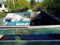
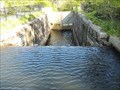 view gallery view galleryS5.6 km |  Schubenacadie Canal - Dartmouth, NS Schubenacadie Canal - Dartmouth, NS
in Engineering Landmarks Beginning in 1826 a project involving hundreds of labourers (eventually) resulted in the construction of the Shubenacadie Canal from Halifax Harbour to the Minas Basin in the Bay of Fundy. posted by: T0SHEA location: Nova Scotia, Canada date approved: 06/01/2021 last visited: never |
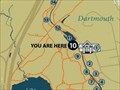 view gallery view galleryS5.6 km | Lock Number 3 - Dartmouth, NS in 'You Are Here' Maps At each informational panel in Shubie Park in Dartmouth is a UR Here Map. This panel is at lock number 3, one of two encircled by the park. posted by: T0SHEA location: Nova Scotia, Canada date approved: 09/28/2016 last visited: never |
 view gallery view galleryS5.6 km |  Shubenacadie Canal - Dartmouth, NS Shubenacadie Canal - Dartmouth, NS
in Wikipedia Entries Beginning in 1826 a project involving hundreds of labourers (eventually) resulted in the construction of the Shubenacadie Canal from Halifax Harbour to the Minas Basin in the Bay of Fundy. posted by: T0SHEA location: Nova Scotia, Canada date approved: 09/29/2016 last visited: 04/28/2018 |
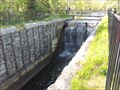
 view gallery view galleryS5.6 km |  Lock 3 - Shubenacadie Canal - Dartmouth, NS Lock 3 - Shubenacadie Canal - Dartmouth, NS
in Waterway Locks, Planes and Lifts Beginning in 1826 a project involving hundreds of labourers (eventually) resulted in the construction of the Shubenacadie Canal from Halifax Harbour to the Minas Basin in the Bay of Fundy. posted by: T0SHEA location: Nova Scotia, Canada date approved: 09/29/2016 last visited: 04/28/2018 |
 view gallery view galleryS5.6 km |  44° 42.118'W 063° 33.276'N - Dartmouth, NS 44° 42.118'W 063° 33.276'N - Dartmouth, NS
in Permanent Geographic Coordinates Beginning in 1826 a project involving hundreds of labourers (eventually) resulted in the construction of the Shubenacadie Canal from Halifax Harbour to the Minas Basin in the Bay of Fundy. posted by: T0SHEA location: Nova Scotia, Canada date approved: 09/29/2016 last visited: never |
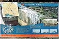 view gallery view galleryS5.6 km |  A Fairbanks Solution - Dartmouth, NS A Fairbanks Solution - Dartmouth, NS
in Signs of History Beginning in 1826 a project involving hundreds of labourers (eventually) resulted in the construction of the Shubenacadie Canal from Halifax Harbour to the Minas Basin in the Bay of Fundy. posted by: T0SHEA location: Nova Scotia, Canada date approved: 09/29/2016 last visited: never |
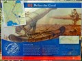 view gallery view galleryS5.6 km | Before the Canal - Dartmouth, NS in Signs of History Beginning in 1826 a project involving hundreds of labourers (eventually) resulted in the construction of the Shubenacadie Canal from Halifax Harbour to the Minas Basin in the Bay of Fundy. posted by: T0SHEA location: Nova Scotia, Canada date approved: 09/29/2016 last visited: never |
 view gallery view galleryS5.6 km | Shubie Park Trail Start - Dartmouth, NS in 'You Are Here' Maps At each informational panel in Shubie Park in Dartmouth is a UR Here map. This is the first of the series, at the start of the Shubie Park Trail around the canal. posted by: T0SHEA location: Nova Scotia, Canada date approved: 09/28/2016 last visited: never |
 view gallery view galleryS5.6 km | 44° 42.099'W 063° 33.239'N - Dartmouth, NS in Permanent Geographic Coordinates Beginning in 1826 a five year long project involving hundreds of labourers (eventually) resulted in the construction of the Shubenacadie Canal from Halifax Harbour to the Minas Basin in the Bay of Fundy. posted by: T0SHEA location: Nova Scotia, Canada date approved: 09/29/2016 last visited: never |
 view gallery view galleryS7.7 km |  Max and 99 - 63º 32.639 - Dartmouth, Nova Scotia, Canada Max and 99 - 63º 32.639 - Dartmouth, Nova Scotia, Canada
in Where's In A Name? Big thanks to Lynx Humble for taking photos for our converted name! posted by: Max and 99 location: Nova Scotia, Canada date approved: 12/03/2019 last visited: 10/28/2019 |
 view gallery view gallery NW8.4 km NW8.4 km
| Waverley #2 Highway Webcam - Waverley, NS in Web Cameras The province of Nova Scotia operates a network of highway webcams throughout the province to aid motorists in assessing road conditions. posted by: T0SHEA location: Nova Scotia, Canada date approved: 09/27/2016 last visited: never |
 view gallery view galleryNW8.4 km | Waverley Highway Webcam - Waverley, NS in Web Cameras The province of Nova Scotia operates a network of highway webcams throughout the province to aid motorists in assessing road conditions. posted by: T0SHEA location: Nova Scotia, Canada date approved: 04/15/2015 last visited: never |
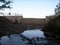 view gallery view galleryNW8.7 km |  Solider Lake Dam - Fall River, Nova Scotia Solider Lake Dam - Fall River, Nova Scotia
in Water Dams This is one of many dams created in Nova Scotia, Canada. posted by:  CrazyDiamond709 CrazyDiamond709 location: Nova Scotia, Canada date approved: 06/29/2012 last visited: never |
 view gallery view galleryW9 km | Lwr Sackville 229407 in Canadian Benchmarks Top of the hill overlooking the on/off ramps from the 102 posted by: Highland Horde location: Nova Scotia, Canada date approved: 09/08/2010 last visited: never |
 view gallery view galleryS9.3 km |  ZINC – AUSTEN, Dartmouth, Nova Scotia ZINC – AUSTEN, Dartmouth, Nova Scotia
in Zinc Headstones A zinc headstone in St. Peter's Cemetery, Dartmouth, Nova Scotia. This one is dedicated to six members of the AUSTEN family. posted by: Falach-fead location: Nova Scotia, Canada date approved: 03/15/2012 last visited: never |
 view gallery view galleryS9.3 km |  McDonald's Nantucket Avenue - Dartmouth, NS McDonald's Nantucket Avenue - Dartmouth, NS
in McDonald's Restaurants This restaurant overlooks the Macdonald Bridge. posted by: elyob location: Nova Scotia, Canada date approved: 07/02/2013 last visited: 10/04/2017 |
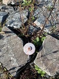 view gallery view galleryW9.3 km | Survey Marker 2011 in Canadian Benchmarks Survey Marker 2011 posted by: DND.Fireman location: Nova Scotia, Canada date approved: 10/01/2021 last visited: never |
 view gallery view gallery SW9.5 km SW9.5 km
|  Cyclist killed in Dartmouth... - Dartmouth, NS Cyclist killed in Dartmouth... - Dartmouth, NS
in News Article Locations The Halifax Chronicle Herald reported on a tragic accident in Dartmouth on May 24, 2014. posted by: T0SHEA location: Nova Scotia, Canada date approved: 06/09/2015 last visited: never |
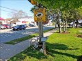
 view gallery view gallerySW9.5 km |  Johanna Dean - Dartmouth, Nova Scotia Johanna Dean - Dartmouth, Nova Scotia
in Ghost Bikes This ghost bike, located on Windmill Road, was placed to honour Johanna Dean. posted by: T0SHEA location: Nova Scotia, Canada date approved: 06/09/2015 last visited: never |
 view gallery view galleryS9.5 km |  Dartmouth Curling Club Dartmouth Curling Club
in Curling Clubs DCC is in downtown Dartmouth and was formed in 1936. posted by: dragonflys location: Nova Scotia, Canada date approved: 03/02/2006 last visited: 10/04/2017 |
 view gallery view galleryS9.7 km | Angus L. Macdonald Bridge - Halifax, NS in Engineering Landmarks The first large suspension bridge in Halifax over Halifax Harbour, it was opened to traffic on April 2, 1955. posted by: T0SHEA location: Nova Scotia, Canada date approved: 06/04/2021 last visited: 06/20/2023 |
 view gallery view galleryS9.7 km |  Angus L. Macdonald Bridge - Halifax, NS Angus L. Macdonald Bridge - Halifax, NS
in People-Named Places The first large suspension bridge in Halifax over Halifax Harbour, it was opened to traffic on April 2, 1955. posted by: T0SHEA location: Nova Scotia, Canada date approved: 05/07/2021 last visited: 06/20/2023 |
|