 view gallery view gallery S2.1 km S2.1 km
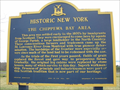
|   The Chippewa Bay Area, Route 12, NY. The Chippewa Bay Area, Route 12, NY.
in New York Historical Markers A 1969 Historic Marker overlooking the Thousand Islands at Chippewa Bay on the St. Lawrence River. posted by:  bluelamb03 bluelamb03 location: New York date approved: 02/02/2011 last visited: 03/28/2023 |
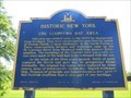
 view gallery view galleryS2.1 km |  The Chippewa Bay Area - Hammond, New York The Chippewa Bay Area - Hammond, New York
in UK Historical Markers This plaque provides information about people from Scotland who were encouraged to immigrate and settle in the area of Hammond, New York, in the early 1800's. posted by: Weathervane location: New York date approved: 05/01/2022 last visited: 03/28/2023 |
 view gallery view galleryS2.1 km |  Scottish Immigration - Chippewa Bay Area - Hammond, New York Scottish Immigration - Chippewa Bay Area - Hammond, New York
in Human Migration Monuments This plaque provides information about people from Scotland who were encouraged to immigrate and settle in the Chippewa Bay area in the early 1800's. posted by: Weathervane location: New York date approved: 05/01/2022 last visited: 03/28/2023 |
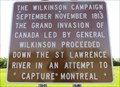 view gallery view galleryS2.3 km |  The Wilkinson Campaign - Hammond, New York The Wilkinson Campaign - Hammond, New York
in War of 1812 This plaque, located in Hammond, New York, provides information about Major General James Wilkinson, who, in September, November 1813, led a campaign to capture Montreal. posted by: Weathervane location: New York date approved: 04/29/2022 last visited: never |
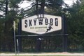 view gallery view gallery W2.7 km W2.7 km
|  Skywood Eco Adventure - Mallorytown, ON Skywood Eco Adventure - Mallorytown, ON
in Ropes Course Located at 1278 Thousand Island Parkway in Mallorytown, Ontario on the North side. posted by: mTn_biKer65 location: Ontario, Canada date approved: 08/30/2016 last visited: never |
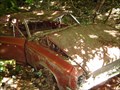 view gallery view galleryW3.2 km |  The Oldsmobile Super 88 The Oldsmobile Super 88
in Abandoned Dead Vehicles An abandoned Olds Super 88 in the woods posted by: Canadianzombie location: Ontario, Canada date approved: 05/31/2011 last visited: 09/28/2012 |
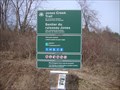 view gallery view galleryW3.5 km |  Jones Creek Hiking Trail, Ontario Canada Jones Creek Hiking Trail, Ontario Canada
in Hiking and walking trailheads St. Lawrence Islands National Park Jones Creek property. The trails are designed in a variety of loops around Jones Creek and Mud Creek. posted by: model12 location: Ontario, Canada date approved: 04/11/2011 last visited: 03/23/2012 |
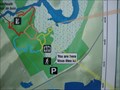 view gallery view galleryW3.5 km |  Jones Creek Trail YAH sign Jones Creek Trail YAH sign
in 'You Are Here' Maps Trail construction at Jones Creek, including a trailhead and parking area, was completed in the fall of 2007. The second phase of the project will begin with the evaluation and layout of trails on the Landon Bay property. posted by: model12 location: Ontario, Canada date approved: 04/11/2011 last visited: 03/23/2012 |
 view gallery view gallery NE4 km NE4 km
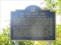
| Historic New York - The Thousand Islands - Route 12, New York State in New York Historical Markers A large marker located in a scenic rest stop west of Jacques Cartier State Park on Route 12. It highlights the Thousand Islands area, provides information on the recreation activities and commemorates the Thousand Islands International Bridge. posted by: Weathervane location: New York date approved: 09/30/2014 last visited: never |
 view gallery view galleryW4.7 km |  A + W - Mallorytown North - Mallorytown, ON, Canadá A + W - Mallorytown North - Mallorytown, ON, Canadá
in A + W Restaurants A+W in Station. posted by: Ariberna location: Ontario, Canada date approved: 03/04/2024 last visited: never |
 view gallery view galleryW4.7 km |  Tim Hortons - Mallorytown North - Mallorytown, ON Tim Hortons - Mallorytown North - Mallorytown, ON
in Tim Horton's Restaurants 678 Hwy 401 Westbound, Mallorytown North, ON K0E 1R0
Accessed Via HWY 401 Westbound Between Exit # 675 And # 687 posted by: Ariberna location: Ontario, Canada date approved: 02/29/2024 last visited: never |
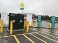 view gallery view galleryW4.7 km |  Car charging Mallority Town North - Mallority, ON, Canada Car charging Mallority Town North - Mallority, ON, Canada
in Electric Car Charging Stations Chargers in station posted by: Ariberna location: Ontario, Canada date approved: 02/29/2024 last visited: never |
 view gallery view galleryW4.7 km |  OnRoute - WI-FI Hotspot - Mallorytown, ON, Canada OnRoute - WI-FI Hotspot - Mallorytown, ON, Canada
in Wi-Fi Hotspots WI-FI of the station posted by: Ariberna location: Ontario, Canada date approved: 02/29/2024 last visited: never |
 view gallery view galleryW4.7 km |  Mallorytown OnRoute - Mallorytown, ON, Canada Mallorytown OnRoute - Mallorytown, ON, Canada
in LEED Buildings Silver Building posted by: Ariberna location: Ontario, Canada date approved: 02/29/2024 last visited: 03/02/2024 |
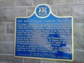 view gallery view galleryW4.7 km |  "THE MACDONALD CARTIER FREEWAY" - Township of Front of Yonge, Ontario "THE MACDONALD CARTIER FREEWAY" - Township of Front of Yonge, Ontario
in Ontario Provincial Plaques This Ontario Heritage Plaque commemorates the completion of Highway 401, the Macdonald-Cartier Freeway. posted by: Trail Blaisers location: Ontario, Canada date approved: 03/15/2014 last visited: 09/19/2015 |
 view gallery view gallery N4.8 km N4.8 km
|  The Cub Cadet on a Stick The Cub Cadet on a Stick
in Elevated Everyday Objects A Cub Cadet Lawn Mower on a Tall Metal Pole posted by: Canadianzombie location: Ontario, Canada date approved: 05/11/2011 last visited: 04/26/2021 |
 view gallery view gallery NW5.1 km NW5.1 km
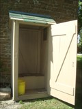
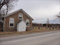
|  The Old Stone Church Outhouse The Old Stone Church Outhouse
in Outhouses An outhouse behind a church in Yonge Mills. posted by: Canadianzombie location: Ontario, Canada date approved: 09/11/2011 last visited: 06/24/2013 |
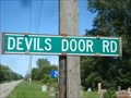 view gallery view galleryNW5.1 km |  Devil's Door Road Devil's Door Road
in Man-made Devilish Locations A Devilish Road in Yonge Mills posted by: Canadianzombie location: Ontario, Canada date approved: 10/13/2011 last visited: 04/03/2021 |
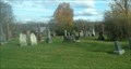 view gallery view galleryNW5.1 km |  Yonge Mills Cemetery - Yonge Mills, ON Yonge Mills Cemetery - Yonge Mills, ON
in Worldwide Cemeteries Historic cemetery in Leeds County posted by: stinger503 location: Ontario, Canada date approved: 01/28/2013 last visited: never |
 view gallery view galleryNW5.1 km |  The Old Stone Church of Yonge Mills Churchyard Cemetery The Old Stone Church of Yonge Mills Churchyard Cemetery
in Churchyard Cemeteries A 175 year old churchyard cemetery in Yonge Mills posted by: Canadianzombie location: Ontario, Canada date approved: 02/21/2012 last visited: 10/18/2022 |
 view gallery view gallery SW5.6 km SW5.6 km
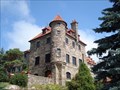
|  Singer Castle - St. Lawrence Seaway - Chippewa Bay, NY Singer Castle - St. Lawrence Seaway - Chippewa Bay, NY
in Castles Singer Castle is located in the St. Lawrence Seaway on the US Side. posted by:  Lightnin Bug Lightnin Bug location: New York date approved: 08/30/2009 last visited: 10/16/2011 |
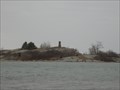 view gallery view gallerySW5.8 km |  Chimney Island - St Lawrence River Chimney Island - St Lawrence River
in Lonely Chimneys A lonely chimney is all that remains from a War of 1812 Garrison. posted by: Canadianzombie location: Ontario, Canada date approved: 03/25/2012 last visited: 06/02/2023 |
 view gallery view gallerySW5.8 km |  CNHS - Chimney Island (Bridge Island) - Mallorytown Landing, Ontario CNHS - Chimney Island (Bridge Island) - Mallorytown Landing, Ontario
in Canadian National Historic Sites CNHS plaque at a convenient roadside stopping place with great views of the St Lawrence and Bridge Island. posted by: model12 location: Ontario, Canada date approved: 04/10/2011 last visited: 06/02/2023 |
 view gallery view galleryW6.3 km | A & W - Mallorytown Service Centre, 401 Westbound in A + W Restaurants This waymark is located in the new ONroute service centre. posted by: elyob location: Ontario, Canada date approved: 08/07/2011 last visited: 03/01/2020 |
 view gallery view galleryW6.3 km |  Mallorytown ONroute Service Centre Westbound Mallorytown ONroute Service Centre Westbound
in Highway Rest Areas Mallorytown ONroute is located on the Westbound Hwy 401 in Ontario. posted by: The Burrow location: Ontario, Canada date approved: 04/14/2014 last visited: 06/26/2019 |
|