 view gallery view gallery E7.4 km E7.4 km
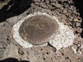
|   USGS H88 1940 8172' USGS H88 1940 8172'
in U.S. Benchmarks Vertical USGS elevation marker on ridge summit in the Strawberry Wilderness. posted by:  segler999 segler999 location: Oregon date approved: 08/22/2007 last visited: never |
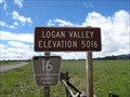
 view gallery view gallery SE15.6 km SE15.6 km
|  Logan Valley (Western Approach) - 5016' Logan Valley (Western Approach) - 5016'
in Elevation Signs Forest Road 16 about 13 miles east of Seneca, Oregon, in the Malheur National Forest. posted by:  WR7X WR7X location: Oregon date approved: 06/15/2013 last visited: 11/27/2020 |
 view gallery view gallery NW17.2 km NW17.2 km
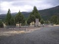
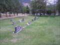
|  Boot Hill - Canyon City, OR Boot Hill - Canyon City, OR
in Worldwide Cemeteries Boot Hill Cemetery on hill east of downtown Canyon City. posted by: Volcanoguy location: Oregon date approved: 12/06/2007 last visited: 12/18/2010 |
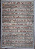 view gallery view galleryNW17.2 km |  As Told by an Old-Timer As Told by an Old-Timer
in Oregon Historical Markers One of two versions of the history of the Boot Hill Cemetery at Canyon City. posted by: Volcanoguy location: Oregon date approved: 12/06/2007 last visited: 06/13/2009 |
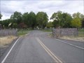 view gallery view galleryNW17.4 km | Canyon City Cemetery - Canyon City, OR in Worldwide Cemeteries Canyon City Cemetery on hill east of downtown Canyon City. posted by: Volcanoguy location: Oregon date approved: 12/06/2007 last visited: 12/18/2010 |
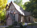 view gallery view galleryNW17.7 km |  St. Thomas’ Episcopal Church - Canyon City, Oregon St. Thomas’ Episcopal Church - Canyon City, Oregon
in This Old Church The 1876 St. Thomas’ Episcopal Church in Canyon City, Oregon. posted by: Volcanoguy location: Oregon date approved: 12/12/2007 last visited: 11/27/2020 |
 view gallery view galleryNW17.7 km |  St. Thomas’ Episcopal Church - Canyon City, OR St. Thomas’ Episcopal Church - Canyon City, OR
in U.S. National Register of Historic Places The St. Thomas’ Episcopal Church in Canyon City, Oregon. posted by: Volcanoguy location: Oregon date approved: 12/12/2007 last visited: 12/12/2007 |
 view gallery view galleryNW17.7 km | St. Andrews Catholic Cemetery - Canyon City, OR in Worldwide Cemeteries St. Andrews Catholic Cemetery on hillside east of downtown Canyon City. posted by: Volcanoguy location: Oregon date approved: 12/06/2007 last visited: 12/18/2010 |
 view gallery view galleryNW17.7 km |  Canyon City, Oregon Canyon City, Oregon
in City and Town Halls The city hall for the community of Canyon City. posted by: Volcanoguy location: Oregon date approved: 12/17/2007 last visited: 11/27/2020 |
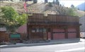
 view gallery view galleryNW17.7 km |  Fire Hall Fire Hall
in Firehouses The Canyon City Fire Hall posted by: Volcanoguy location: Oregon date approved: 12/16/2007 last visited: 01/17/2011 |
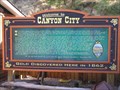 view gallery view galleryNW17.7 km | Welcome to Canyon City in Oregon Historical Markers History sign near Canyon City City Hall. posted by: Volcanoguy location: Oregon date approved: 12/07/2007 last visited: 11/27/2020 |
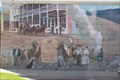 view gallery view galleryNW17.7 km |  “62 Days” Mural -- Canyon City, Oregon “62 Days” Mural -- Canyon City, Oregon
in Murals Mural in downtown Canyon City. posted by: Volcanoguy location: Oregon date approved: 12/15/2007 last visited: 11/27/2020 |
 view gallery view galleryNW17.7 km |  Grant County Courthouse - Canyon City, Oregon Grant County Courthouse - Canyon City, Oregon
in Courthouses The Grant County Courthouse in Canyon City, Oregon posted by: ddtfamily location: Oregon date approved: 08/16/2012 last visited: 11/27/2020 |
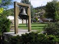 view gallery view galleryNW17.7 km |  Bell in Canyon City Park, Oregon Bell in Canyon City Park, Oregon
in Bells Memorial Bell in Canyon City Park, Oregon posted by: Volcanoguy location: Oregon date approved: 12/16/2007 last visited: 01/17/2011 |
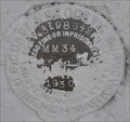 view gallery view galleryNW17.7 km | QC0089 - USCGS MM34, OR in U.S. Benchmarks USCGS benchmark MM34 posted by: Volcanoguy location: Oregon date approved: 10/25/2007 last visited: 10/25/2007 |
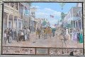 view gallery view galleryNW17.7 km | Fourth of July Parade! Mural -- Canyon City, Oregon in Murals Mural in downtown Canyon City. posted by: Volcanoguy location: Oregon date approved: 12/15/2007 last visited: 11/27/2020 |
 view gallery view galleryNW17.9 km |  Canyon City, OR, 97820 Canyon City, OR, 97820
in U.S. Post Offices The Canyon City, OR Post Office. posted by: Volcanoguy location: Oregon date approved: 10/15/2007 last visited: 11/27/2020 |
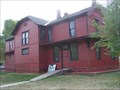 view gallery view gallery N18.3 km N18.3 km
|  Prairie City Depot - Prairie City, Oregon Prairie City Depot - Prairie City, Oregon
in Train Stations/Depots The Sumpter Valley Railroad’s Prairie City Depot was built in 1910. posted by: Volcanoguy location: Oregon date approved: 12/18/2007 last visited: 11/27/2020 |
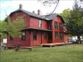 view gallery view galleryN18.3 km | Sumpter Valley Railway Passenger Station - Prairie City, OR in U.S. National Register of Historic Places The Sumpter Valley Railway Passenger Station in Prairie City, Oregon. posted by: Volcanoguy location: Oregon date approved: 12/19/2007 last visited: 06/12/2009 |
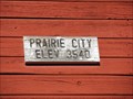 view gallery view galleryN18.3 km | Prairie City, Oregon - 3540' in Elevation Signs The sign is located on the former train depot (now museum) in Prairie City. posted by: WR7X location: Oregon date approved: 06/01/2013 last visited: 11/27/2020 |
 view gallery view gallerySE18.5 km | Logan Valley (Eastern Approach) - 5016' in Elevation Signs Forest Road 16 about 15 miles east of Seneca, Oregon, in the Malheur National Forest. posted by: WR7X location: Oregon date approved: 06/09/2012 last visited: never |
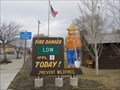 view gallery view galleryN18.7 km |  Smokey at Prairie City Ranger Station - Prairie City, OR Smokey at Prairie City Ranger Station - Prairie City, OR
in Smokey Bear Sign Sightings Smokey is at the Malheur National Forest Prairie City Ranger Station. posted by: WR7X location: Oregon date approved: 02/27/2014 last visited: 11/27/2020 |
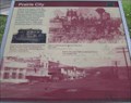 view gallery view galleryN18.7 km | Prairie City, OR, 97869 in Oregon Historical Markers History sign near Prairie City City Hall. posted by: Volcanoguy location: Oregon date approved: 12/07/2007 last visited: 12/07/2007 |
 view gallery view galleryN18.7 km | Prairie City, Oregon in City and Town Halls The city hall for the community of Prairie City. posted by: Volcanoguy location: Oregon date approved: 12/17/2007 last visited: 11/27/2020 |
 view gallery view galleryN18.8 km | Prairie City Fire Station in Firehouses The Prairie City Fire Station on Kilbourne Street. posted by: Volcanoguy location: Oregon date approved: 12/17/2007 last visited: 07/10/2017 |
|