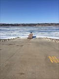
 view gallery view gallery S0.5 km S0.5 km
|   American Creek Boat Ramp American Creek Boat Ramp
in Boat Ramps Located in American Creek Campground, Chamberlain, SD posted by:  NGComets NGComets location: South Dakota date approved: 06/01/2020 last visited: never |
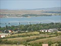
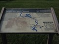
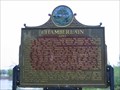 view gallery view galleryS0.8 km |  Chamberlain ~1880~ Chamberlain ~1880~
in South Dakota Historical Markers Named for Selah Chamberlain, a Milwaukee RR official, the site was the scene of an encounter between Jean Baptiste Trudeau and the Teton Sioux in 1794 and when Samuel H Morrow surveyed the area, in 1868 he found a ranch on American Creek. posted by: MNSearchers location: South Dakota date approved: 05/06/2007 last visited: 05/06/2007 |
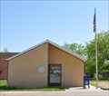
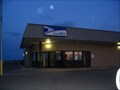
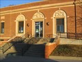 view gallery view galleryS1.3 km |  Chamberlain, South Dakota 57325 Chamberlain, South Dakota 57325
in U.S. Post Offices Small city post office. posted by: NGComets location: South Dakota date approved: 04/14/2009 last visited: never |
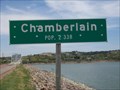 view gallery view gallery SW1.6 km SW1.6 km
|  Population Sign, Chamberlain, South Dakota Population Sign, Chamberlain, South Dakota
in Population Signs County seat of Brule County. posted by: NGComets location: South Dakota date approved: 05/10/2012 last visited: never |
 view gallery view gallerySW1.6 km |  Missouri River Bridges of South Dakota Missouri River Bridges of South Dakota
in Engineering Landmarks A group of 5 bridges recognized as historic civil engineering landmarks. posted by:  Telomere Telomere location: South Dakota date approved: 09/12/2016 last visited: 09/28/2018 |
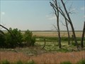
 view gallery view gallerySW2.4 km | American Island in South Dakota Historical Markers AKA Cedar Island was submerged when Lake Francis Case formed in 1953 and since. posted by: plainsdrifter358 location: South Dakota date approved: 05/22/2006 last visited: 05/05/2007 |
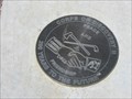 view gallery view galleryS4 km |  Corps of Discovery II - Chamberlain, South Dakota Corps of Discovery II - Chamberlain, South Dakota
in U.S. Benchmarks Corps of Discovery II – Chamberlain, SD, is a 12-inch Lewis and Clark commemorative disk located near the Lewis and Clark Information Center south of Chamberlain. posted by: seventhings location: South Dakota date approved: 11/23/2005 last visited: 09/28/2018 |
 view gallery view galleryS4 km |  Lewis & Clark - Chamberlain SD - 1718 ft. Lewis & Clark - Chamberlain SD - 1718 ft.
in Elevation Signs Elevation of 1718 feet is specified on the bronze sign which explains the round marker. posted by: Telomere location: South Dakota date approved: 09/09/2016 last visited: 09/28/2018 |
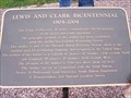 view gallery view galleryS4 km |  43d 47m 13.66s N 99d 20m 18.16s W - Chamberlain, SD 43d 47m 13.66s N 99d 20m 18.16s W - Chamberlain, SD
in Permanent Geographic Coordinates Lewis and Clark Bicentennial Sign at a Chamberlain, SD rest stop. posted by: Team 57 location: South Dakota date approved: 06/18/2010 last visited: 09/28/2018 |
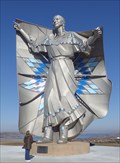 view gallery view galleryS4 km |  Dignity — Chamberlain, SD Dignity — Chamberlain, SD
in Figurative Public Sculpture Native American woman personifying dignity. posted by: ronjean location: South Dakota date approved: 11/20/2017 last visited: 09/17/2023 |
 view gallery view galleryS4 km | Civilian Conservation Corps Camps in South Dakota Historical Markers HM commemorating the CCC, a Federal work-relief program during the great depression (1933 to 1942). posted by: plainsdrifter358 location: South Dakota date approved: 04/16/2006 last visited: 10/01/2016 |
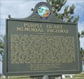 view gallery view galleryS4 km | Purple Heart Memorial Highway in South Dakota Historical Markers This South Dakota Historical Marker is at the Chamberlain SD Rest Area near MM 266 on I-90 near Chamberlain, South Dakota. posted by: PeterNoG location: South Dakota date approved: 11/09/2016 last visited: 08/04/2022 |
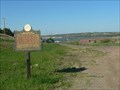
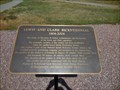
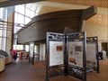
 view gallery view galleryS4 km | Sojorn at Camp Pleasant - Chamberlain, SD in South Dakota Historical Markers This marker can be found at a rest stop with an ajoining information area on the Lewis and Clark expedition. posted by: gparkes location: South Dakota date approved: 07/05/2009 last visited: 07/19/2022 |
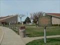
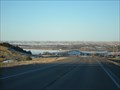
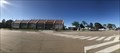 view gallery view galleryS4.2 km |  Chamberlain South Dakota Rest Area - Chamberlain, South Dakota Chamberlain South Dakota Rest Area - Chamberlain, South Dakota
in Highway Rest Areas A Rest stop and Lewis and Clark Interpretive Center overlooking the Missouri River posted by: flyingmoose location: South Dakota date approved: 09/04/2020 last visited: 12/15/2022 |
 view gallery view galleryS4.2 km |  55 foot Keelboat - Chamberlain, SD 55 foot Keelboat - Chamberlain, SD
in Exact Replicas A replica of the historic keelboats which helped establish commerce and exploration in this region. posted by: Telomere location: South Dakota date approved: 09/10/2016 last visited: 12/14/2022 |
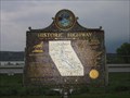 view gallery view gallerySW4.8 km | Historic Highway ~Chamberlain~ in South Dakota Historical Markers East on US 18 to W to SD 47 on US 18 posted by: MNSearchers location: South Dakota date approved: 05/06/2007 last visited: 05/06/2007 |
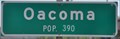 view gallery view gallerySW5.6 km | Oacoma, South Dakota ~ Population 390 in Population Signs This Population Sign is on the north side of South Dakota Highway 16 at the northeastern town limits of Oacoma, South Dakota. posted by: brwhiz location: South Dakota date approved: 12/18/2012 last visited: never |
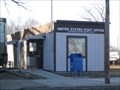
 view gallery view gallerySW6.1 km | Oacoma, South Dakota 57365 in U.S. Post Offices This Post Office is located at 101 W 2nd Street in Oacoma, South Dakota. posted by: brwhiz location: South Dakota date approved: 01/27/2013 last visited: never |
 view gallery view galleryS8.4 km | Ft. Ridgley & South Pass Federal Wagon Road ~ 1st Road in Dakota circa 1857 in South Dakota Historical Markers First road in South Dakota - Fort Ridgley and South Pass Federal Wagon Road opened in 1857. posted by: plainsdrifter358 location: South Dakota date approved: 07/08/2006 last visited: 06/13/2006 |
 view gallery view gallery E12.7 km E12.7 km
| Pukwana, South Dakota 57370 in U.S. Post Offices Small town post office. posted by: NGComets location: South Dakota date approved: 04/14/2009 last visited: never |
 view gallery view gallery SE14.5 km SE14.5 km
|  Red Lake Red Lake
in U.S. National Natural Landmarks Red Lake is one of the largest remaining natural and unmanipulated prairie pothole lakes.
posted by: plainsdrifter358 location: South Dakota date approved: 07/08/2006 last visited: 06/13/2006 |
 view gallery view gallery W23.5 km W23.5 km
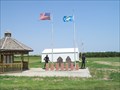
|  Local Veterans Memorial - Reliance, South Dakota Local Veterans Memorial - Reliance, South Dakota
in Non-Specific Veteran Memorials Located in Reliance, SD, just 15 miles west of Chamberlain on US Interstate 90. posted by: NGComets location: South Dakota date approved: 07/15/2012 last visited: never |
 view gallery view galleryW23.5 km |  Cemetery, Reliance, South Dakota Cemetery, Reliance, South Dakota
in Worldwide Cemeteries Located just north of town. posted by: NGComets location: South Dakota date approved: 07/06/2012 last visited: never |
 view gallery view gallery N28.2 km N28.2 km
|  Big Bend Dam - Ft. Thompson, SD Big Bend Dam - Ft. Thompson, SD
in Water Dams Big Bend Dam located just west of Ft. Thompson, SD posted by: dbrockhouse location: South Dakota date approved: 02/25/2011 last visited: never |
 view gallery view galleryN28.8 km | Ft. Thompson, South Dakota 57339 in U.S. Post Offices Small town post office on a Reservation. posted by: NGComets location: South Dakota date approved: 05/06/2009 last visited: never |
|