 view gallery view gallery NE7.2 km NE7.2 km
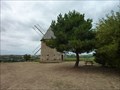
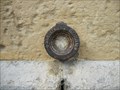
|   Le moulin de pesquies Le moulin de pesquies
in Windmills Le moulin à vent de Pesquies.
Restauré en 1991, il ne fonctionne plus. posted by:  niko_kristyn niko_kristyn location: Occitanie, France date approved: 07/31/2017 last visited: never |
 view gallery view gallery N18 km N18 km
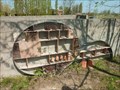
|  L'hôtel à insectes de Lherm L'hôtel à insectes de Lherm
in Insect Hotels Magnifique hôtel à insectes posted by: niko_kristyn location: Occitanie, France date approved: 07/28/2017 last visited: never |
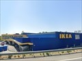 view gallery view galleryN26.9 km |  IKEA Toulouse - France IKEA Toulouse - France
in IKEA IKEA store in Toulouse posted by:  Max93600 Max93600 location: Occitanie, France date approved: 10/07/2021 last visited: never |
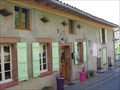 view gallery view galleryNE30.3 km |  Au Gré du Temps - Donneville, France Au Gré du Temps - Donneville, France
in Bed and Breakfast [FR] Blottie au coeur du village de Donneville, à 15 mn au sud-est de Toulouse, à 10 mn du métro-parking et à deux pas du canal du midi. [EN] Located in the heart of the village of Donneville, 15 minutes south-west of Toulouse. posted by: RakeInTheCache location: Occitanie, France date approved: 05/07/2012 last visited: never |
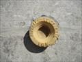
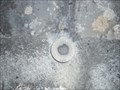 view gallery view gallery SW32.3 km SW32.3 km
|  Benchmark - Petit pont - Caumont Benchmark - Petit pont - Caumont
in French Benchmarks Localisation : A 150 M AU NORD-EST DU CARREFOUR AVEC LA D.117
Support : PONT
Partie support : PARAPET AVAL, FACE ROUTE
Altitude : 354,400 m posted by: eolas location: Occitanie, France date approved: 02/21/2013 last visited: never |
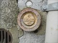
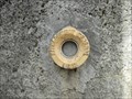
 view gallery view gallerySW32.3 km | Benchmark - l'Eglise - Caumont in French Benchmarks Support : EGLISE DE CAUMONT
Partie support : MUR DE FACADE ANTERIEUR, FACE SUD-OUEST, FACE ROUTE
Altitude : 359,171 m posted by: eolas location: Occitanie, France date approved: 02/21/2013 last visited: never |
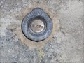
 view gallery view gallerySW33 km | Benchmark - Petit pont - Lorp in French Benchmarks Localisation : A 40 M AU SUD-EST DU CARREFOUR AVEC UN CHEMIN
Support : PONCEAU SUR LE MARCAZEAU
Altitude : 372,424 m posted by: eolas location: Occitanie, France date approved: 02/21/2013 last visited: never |
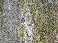
 view gallery view gallery S33.2 km S33.2 km
| Benchmark - LA PEYRADE - Lorp in French Benchmarks Localisation : AU LIEU-DIT "LA PEYRADE", AU NO 26, AVENUE CHARLES DE GAULLE
Altitude : 377,331 m posted by: eolas location: Occitanie, France date approved: 02/21/2013 last visited: 09/17/2009 |
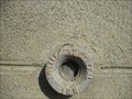
 view gallery view galleryS33.3 km | Benchmark - EGLISE DE LORP in French Benchmarks Partie support : ABOUT DU TROISIEME CONTREFORT A COMPTER DE LA ROUTE, DANS LE MUR DE FACADE
ANTERIEUR
Altitude : 377,995 m posted by: eolas location: Occitanie, France date approved: 02/21/2013 last visited: never |
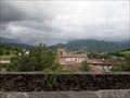
 view gallery view galleryS33.6 km |  Cathédrale Saint-Lizier - Saint-Lizier Cathédrale Saint-Lizier - Saint-Lizier
in Monuments Historiques Français Première cathédrale du village de Saint-Lizier avec son cloître roman, rare en Occitanie et le seul en Ariège. posted by: 09Naturel location: Occitanie, France date approved: 06/28/2018 last visited: 02/24/2020 |
 view gallery view galleryS33.6 km |  Cathédrale Saint-Lizier - Saint-Lizier Cathédrale Saint-Lizier - Saint-Lizier
in World Heritage Sites Première cathédrale du village de Saint-Lizier avec son cloître roman, rare en Occitanie et le seul en Ariège. posted by: 09Naturel location: Occitanie, France date approved: 06/28/2018 last visited: 02/24/2020 |
 view gallery view galleryS33.6 km |  Cathédrale Saint-Lizier - Saint-Lizier Cathédrale Saint-Lizier - Saint-Lizier
in Cathedrals Première cathédrale du village de Saint-Lizier avec son cloître roman, rare en Occitanie et le seul en Ariège. posted by: 09Naturel location: Occitanie, France date approved: 06/28/2018 last visited: 02/24/2020 |
 view gallery view galleryS33.6 km | Benchmark - EE' - 43 BIS - Saint-Lizier in French Benchmarks Localisation : AU NORD-OUEST DU CARREFOUR GIRATOIRE AVEC LA D.33A
Support : MUR DE CLOTURE
*** Ce repère n'a pas été observé par l' I.G.N.
Altitude : 386,417 m posted by: eolas location: Occitanie, France date approved: 02/21/2013 last visited: never |
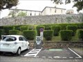 view gallery view galleryS33.8 km |  Borne de recharge - Vigne de l'évêché, Saint-Lizier Borne de recharge - Vigne de l'évêché, Saint-Lizier
in Electric Car Charging Stations 2 points de charge disponibles, place Vigne de L'Eveche, d'une puissance de 22kW max chacun. posted by: 09Naturel location: Occitanie, France date approved: 06/27/2018 last visited: 02/24/2020 |
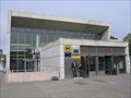 view gallery view galleryNE34.1 km |  Ramonville - Toulouse, France Ramonville - Toulouse, France
in The Underground [FR] La station Ramonville est le terminus de la ligne B du métro de Toulouse. [EN] The Ramonville station is the terminus of line B of the Toulouse metro. posted by: RakeInTheCache location: Occitanie, France date approved: 05/07/2012 last visited: never |
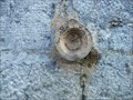
 view gallery view galleryS34.9 km | Benchmark - ANCIEN COLLEGE D'ENSEIGNEMENT TECHNIQUE in French Benchmarks Localisation : A SAINT-GIRONS, AU NO 28 DE L'AVENUE RENE PLAISANT
Support : MAISON (ANCIEN COLLEGE D'ENSEIGNEMENT TECHNIQUE)
Altitude : 390,435 m posted by: eolas location: Occitanie, France date approved: 02/21/2013 last visited: never |
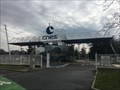 view gallery view galleryNE34.9 km |  Le CNES - Toulouse - France Le CNES - Toulouse - France
in Research Institutes Le site du Centre national d'études spatiales.
The site of the National Center for Space Studies. posted by: Alfouine location: Centre-Val-de-Loire, France date approved: 04/17/2018 last visited: 05/24/2022 |
 view gallery view galleryNE34.9 km |  Le CNES - Toulouse - France Le CNES - Toulouse - France
in Wikipedia Entries Le site du Centre national d'études spatiales.
The site of the National Center for Space Studies. posted by: Alfouine location: Occitanie, France date approved: 02/10/2018 last visited: never |
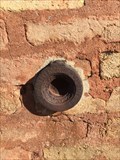 view gallery view galleryN34.9 km | Repère de nivellement - Cimetière - Pujaudran, France in French Benchmarks Repère de nivellement sur le pilier Est du portail posted by: lynx36 location: Occitanie, France date approved: 04/27/2020 last visited: 02/19/2019 |
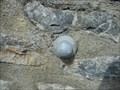
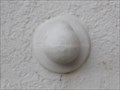 view gallery view galleryS35.1 km | Benchmark - L'ancienne gare - Saint-Girons in French Benchmarks Type : REPERE BOULE
Localisation : A 50 M A L'OUEST DE LA D.117
Support : GARE DE SAINT-GIRONS
Partie support : MUR DE FACADE DE L'AILE NORD, FACE VOIE FERREE
*** Ce repère n'a pas été observé par l' I.G.N.
Altitude : 391,720 m posted by: eolas location: Occitanie, France date approved: 02/20/2013 last visited: never |
 view gallery view galleryS35.2 km | Benchmark Pont neuf - Saint-Girons in French Benchmarks Localisation : A L'ANGLE SUD-OUEST DU SQUARE BALAGUE
Support : PONT SUR LE SALAT
Altitude : 390,329 m posted by: eolas location: Occitanie, France date approved: 02/21/2013 last visited: never |
 view gallery view galleryS35.2 km | Benchmark L'église de Saint-Girons in French Benchmarks Localisation : A 190 M AU SUD DU CARREFOUR DE LA D.117 ET DE LA RUE DU MARCHE, PLACE DE VERDUN
Partie support : ABOUT DU 2EME CONTREFORT DU TRANSEPT GAUCHE A PARTIR DU CHOEUR, FACE A LA
PLACE, FACE NORD-OUEST
Altitude: 390.818 m. posted by: eolas location: Occitanie, France date approved: 02/20/2013 last visited: never |
 view gallery view galleryN35.2 km |  Stadium de Toulouse (TFC) - Toulouse, Occitanie, France Stadium de Toulouse (TFC) - Toulouse, Occitanie, France
in FIFA World Cup Venues Stadium de Toulouse (treizième stade de France par la capacité), situé sur l'île du Ramier. Le stade accueille l'équipe professionnelle du Toulouse Football Club (TFC), et a accueilli des matchs lors des coupes du monde FIFA de 1938 et 1998. posted by: 09Naturel location: Occitanie, France date approved: 07/02/2018 last visited: 05/24/2022 |
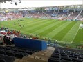 view gallery view galleryN35.2 km |  Stadium de Toulouse (TFC) - Toulouse, Occitanie, France Stadium de Toulouse (TFC) - Toulouse, Occitanie, France
in Professional Sports Venues Stadium de Toulouse (treizième stade de France par la capacité), situé sur l'île du Ramier. Le stade accueille l'équipe professionnelle du Toulouse Football Club (TFC), et occasionnellement des matchs de rugby du Stade Toulousain. posted by: 09Naturel location: Occitanie, France date approved: 06/30/2018 last visited: 05/24/2022 |
 view gallery view galleryS35.4 km | Benchmark E.C.O3P3 - 1 - Saint-Girons in French Benchmarks Support : ECOLE PAUL SAINT-ALARY
Partie support : SOUBASSEMENT DU MUR DE FACADE SUD-OUEST, FACE PLACE
Altitude : 391,825 m posted by: eolas location: Occitanie, France date approved: 02/20/2013 last visited: never |
|