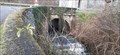
 view gallery view gallery W30.6 km W30.6 km
|   Pont sur la Gèze - Castelnau Magnoac, France Pont sur la Gèze - Castelnau Magnoac, France
in Arch Bridges a small bridge under the Gers road.
un petit pont sous la route du Gers. posted by:  sara et gege sara et gege location: Occitanie, France date approved: 02/14/2021 last visited: 10/28/2021 |
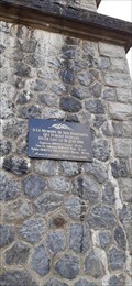 view gallery view galleryW30.6 km |  Les resistants fusillés - - Castelnau Magnoac, France Les resistants fusillés - - Castelnau Magnoac, France
in World War II Memorials / Monuments a plaque and a cross in memory of the resistance fighters.
une plaque et une croix a la mémoire des résistants. posted by: sara et gege location: Occitanie, France date approved: 02/13/2021 last visited: 10/28/2021 |
 view gallery view galleryW30.6 km | memoire des resistants - Castelnau Magnoac, France in World War II Sites a plaque and a cross in memory of the resistance fighters.
une plaque et une croix a la mémoire des résistants. posted by: sara et gege location: Occitanie, France date approved: 02/13/2021 last visited: 11/02/2021 |
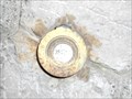
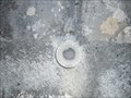 view gallery view gallery SE31.7 km SE31.7 km
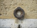
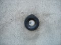
|  Benchmark - Petit pont - Caumont Benchmark - Petit pont - Caumont
in French Benchmarks Localisation : A 150 M AU NORD-EST DU CARREFOUR AVEC LA D.117
Support : PONT
Partie support : PARAPET AVAL, FACE ROUTE
Altitude : 354,400 m posted by: eolas location: Occitanie, France date approved: 02/21/2013 last visited: never |
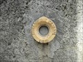
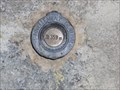 view gallery view gallerySE31.9 km | Benchmark - l'Eglise - Caumont in French Benchmarks Support : EGLISE DE CAUMONT
Partie support : MUR DE FACADE ANTERIEUR, FACE SUD-OUEST, FACE ROUTE
Altitude : 359,171 m posted by: eolas location: Occitanie, France date approved: 02/21/2013 last visited: never |
 view gallery view gallery NE32 km NE32 km
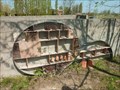
|  L'hôtel à insectes de Lherm L'hôtel à insectes de Lherm
in Insect Hotels Magnifique hôtel à insectes posted by:  niko_kristyn niko_kristyn location: Occitanie, France date approved: 07/28/2017 last visited: never |
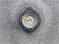
 view gallery view gallerySE33.8 km | Benchmark - Petit pont - Lorp in French Benchmarks Localisation : A 40 M AU SUD-EST DU CARREFOUR AVEC UN CHEMIN
Support : PONCEAU SUR LE MARCAZEAU
Altitude : 372,424 m posted by: eolas location: Occitanie, France date approved: 02/21/2013 last visited: never |
 view gallery view gallery E34.8 km E34.8 km
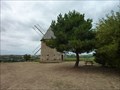
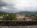
|  Le moulin de pesquies Le moulin de pesquies
in Windmills Le moulin à vent de Pesquies.
Restauré en 1991, il ne fonctionne plus. posted by: niko_kristyn location: Occitanie, France date approved: 07/31/2017 last visited: never |
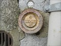
 view gallery view gallerySE34.8 km | Benchmark - LA PEYRADE - Lorp in French Benchmarks Localisation : AU LIEU-DIT "LA PEYRADE", AU NO 26, AVENUE CHARLES DE GAULLE
Altitude : 377,331 m posted by: eolas location: Occitanie, France date approved: 02/21/2013 last visited: 09/17/2009 |
 view gallery view gallerySE35.2 km | Benchmark - EGLISE DE LORP in French Benchmarks Partie support : ABOUT DU TROISIEME CONTREFORT A COMPTER DE LA ROUTE, DANS LE MUR DE FACADE
ANTERIEUR
Altitude : 377,995 m posted by: eolas location: Occitanie, France date approved: 02/21/2013 last visited: never |
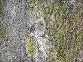
 view gallery view gallerySE36.4 km | Benchmark - EE' - 43 BIS - Saint-Lizier in French Benchmarks Localisation : AU NORD-OUEST DU CARREFOUR GIRATOIRE AVEC LA D.33A
Support : MUR DE CLOTURE
*** Ce repère n'a pas été observé par l' I.G.N.
Altitude : 386,417 m posted by: eolas location: Occitanie, France date approved: 02/21/2013 last visited: never |
 view gallery view gallerySE36.7 km |  Cathédrale Saint-Lizier - Saint-Lizier Cathédrale Saint-Lizier - Saint-Lizier
in Monuments Historiques Français Première cathédrale du village de Saint-Lizier avec son cloître roman, rare en Occitanie et le seul en Ariège. posted by: 09Naturel location: Occitanie, France date approved: 06/28/2018 last visited: 02/24/2020 |
 view gallery view gallerySE36.7 km |  Cathédrale Saint-Lizier - Saint-Lizier Cathédrale Saint-Lizier - Saint-Lizier
in World Heritage Sites Première cathédrale du village de Saint-Lizier avec son cloître roman, rare en Occitanie et le seul en Ariège. posted by: 09Naturel location: Occitanie, France date approved: 06/28/2018 last visited: 02/24/2020 |
 view gallery view gallerySE36.7 km |  Cathédrale Saint-Lizier - Saint-Lizier Cathédrale Saint-Lizier - Saint-Lizier
in Cathedrals Première cathédrale du village de Saint-Lizier avec son cloître roman, rare en Occitanie et le seul en Ariège. posted by: 09Naturel location: Occitanie, France date approved: 06/28/2018 last visited: 02/24/2020 |
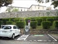 view gallery view gallerySE36.7 km |  Borne de recharge - Vigne de l'évêché, Saint-Lizier Borne de recharge - Vigne de l'évêché, Saint-Lizier
in Electric Car Charging Stations 2 points de charge disponibles, place Vigne de L'Eveche, d'une puissance de 22kW max chacun. posted by: 09Naturel location: Occitanie, France date approved: 06/27/2018 last visited: 02/24/2020 |
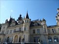
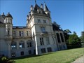 view gallery view gallery SW37.3 km SW37.3 km
|  Château de Valmirande - Montrejeau - Midi-Pyrenees - France Château de Valmirande - Montrejeau - Midi-Pyrenees - France
in Castles Le château de Valmirande se situe à Montréjeau posted by: CADS11 location: Occitanie, France date approved: 07/02/2016 last visited: 11/13/2022 |
 view gallery view gallerySW37.3 km | Château de Valmirande - Montrejeau - Midi-Pyrenees - France in Monuments Historiques Français Le château de Valmirande se situe à Montréjeau posted by: CADS11 location: Occitanie, France date approved: 07/07/2016 last visited: 10/14/2018 |
 view gallery view gallerySW37.5 km |  Château de Valmirande - Montrejeau - Midi-Pyrenees - France Château de Valmirande - Montrejeau - Midi-Pyrenees - France
in Wikipedia Entries Le château de Valmirande se situe à Montréjeau posted by: CADS11 location: Occitanie, France date approved: 07/02/2016 last visited: 01/03/2018 |
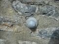
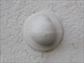 view gallery view gallerySE38 km | Benchmark - L'ancienne gare - Saint-Girons in French Benchmarks Type : REPERE BOULE
Localisation : A 50 M A L'OUEST DE LA D.117
Support : GARE DE SAINT-GIRONS
Partie support : MUR DE FACADE DE L'AILE NORD, FACE VOIE FERREE
*** Ce repère n'a pas été observé par l' I.G.N.
Altitude : 391,720 m posted by: eolas location: Occitanie, France date approved: 02/20/2013 last visited: never |
 view gallery view gallerySE38.3 km | Benchmark - E.C.N3O3 - 37 - Saint-Girons in French Benchmarks Localisation : AU QUARTIER DE LEDAR, AU NO 19, AVENUE DU MARECHAL FOCH
Partie support : SOUBASSEMENT DU MUR PIGNON NORD-OUEST, FACE ROUTE
Altitude : 394,549 m posted by: eolas location: Occitanie, France date approved: 02/20/2013 last visited: never |
 view gallery view gallerySE38.3 km | Benchmark - E.C.N3O3 - 36 - Saint-Girons in French Benchmarks Localisation : AVENUE DU MARECHAL FOCH (D.618)
AU QUARTIER LEDAR, AU NO 43, AVENUE DU MARECHAL FOCH
Altitude : 397,006 m posted by: eolas location: Occitanie, France date approved: 02/20/2013 last visited: never |
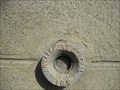
 view gallery view gallerySE38.5 km | Benchmark Pont neuf - Saint-Girons in French Benchmarks Localisation : A L'ANGLE SUD-OUEST DU SQUARE BALAGUE
Support : PONT SUR LE SALAT
Altitude : 390,329 m posted by: eolas location: Occitanie, France date approved: 02/21/2013 last visited: never |
 view gallery view gallerySE38.5 km | Benchmark - Eglise de Lédar in French Benchmarks Localisation : EGLISE
Partie support : MUR DE FACADE SUD-EST DE LA NEF, FACE ROUTE
Altitude : 400,198 m posted by: eolas location: Occitanie, France date approved: 02/20/2013 last visited: never |
 view gallery view gallerySE38.5 km | Benchmark - ANCIEN COLLEGE D'ENSEIGNEMENT TECHNIQUE in French Benchmarks Localisation : A SAINT-GIRONS, AU NO 28 DE L'AVENUE RENE PLAISANT
Support : MAISON (ANCIEN COLLEGE D'ENSEIGNEMENT TECHNIQUE)
Altitude : 390,435 m posted by: eolas location: Occitanie, France date approved: 02/21/2013 last visited: never |
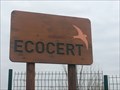 view gallery view gallery N38.6 km N38.6 km
|  ECOCERT - L'Isle Jourdain - France ECOCERT - L'Isle Jourdain - France
in LEED Buildings ECOCERT TRADUIT SON ENGAGEMENT POUR L'ENVIRONNEMENT DANS LA CONSTRUCTION DE SON SIÈGE SOCIAL.
ECOCERT TRANSLATED ITS COMMITMENT TO THE ENVIRONMENT IN THE CONSTRUCTION OF ITS HEAD OFFICE. posted by: Alfouine location: Occitanie, France date approved: 02/11/2018 last visited: 06/06/2022 |
|