 view gallery view gallery SW0 km SW0 km
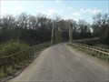
|   Borman Bridge - Valentine, NE Borman Bridge - Valentine, NE
in U.S. National Register of Historic Places Borman Bridge on Niobrara River near Valentine, NE posted by:  plainsdrifter358 plainsdrifter358 location: Nebraska date approved: 06/07/2008 last visited: 07/27/2009 |
 view gallery view gallerySW0 km |  Borman Truss Bridge on Niobrara River, Valentine, NE Borman Truss Bridge on Niobrara River, Valentine, NE
in Truss Bridges Borman Bridge on Niobrara River near Valentine, NE posted by: plainsdrifter358 location: Nebraska date approved: 06/09/2008 last visited: 06/24/2009 |
 view gallery view gallery W1.1 km W1.1 km
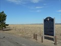
|  Fort Niobrara Fort Niobrara
in Nebraska Historical Markers Fort Niobrara, built in 1880 near Valentine, NE, was established to provide military protection of settlers in the region. posted by: plainsdrifter358 location: Nebraska date approved: 05/11/2008 last visited: 06/24/2009 |
 view gallery view gallery S2.3 km S2.3 km
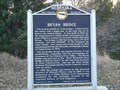
| Bryan Bridge in Nebraska Historical Markers 1932 Bridge along old US 20 near Valentine crossing the Niobrara River. posted by: plainsdrifter358 location: Nebraska date approved: 11/13/2007 last visited: 10/21/2019 |
 view gallery view galleryS2.3 km | Bryan Bridge - Valentine, NE in U.S. National Register of Historic Places Award winning 1932 Bridge along old US 20 near Valentine crossing the Niobrara River. posted by: plainsdrifter358 location: Nebraska date approved: 11/14/2007 last visited: 06/27/2014 |
 view gallery view gallery NW3.4 km NW3.4 km
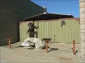
|  Land of the Buffalo Song Land of the Buffalo Song
in Figurative Public Sculpture Native American Hunter on Main Street in Valentine, NE posted by: plainsdrifter358 location: Nebraska date approved: 06/06/2008 last visited: never |
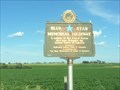
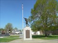 view gallery view galleryNW3.5 km |  Multi-War Memorial, Cherry County, Valentine, NE Multi-War Memorial, Cherry County, Valentine, NE
in Non-Specific Veteran Memorials War Memorial on Main Street in Valentine, NE posted by: plainsdrifter358 location: Nebraska date approved: 06/06/2008 last visited: 06/29/2014 |
 view gallery view gallery N3.5 km N3.5 km
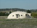
|  Parked UFO Home, Valentine, NE Parked UFO Home, Valentine, NE
in Odd-Shaped Buildings Private home along NE Hwy 12 about 2 miles east of Valentine, NE posted by: plainsdrifter358 location: Nebraska date approved: 06/11/2008 last visited: never |
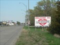 view gallery view galleryNW3.9 km |  Welcome to Nebraska's Valentine Heart City Welcome to Nebraska's Valentine Heart City
in Welcome Signs Welcome to Valentine, NE posted by: plainsdrifter358 location: Nebraska date approved: 06/06/2008 last visited: never |
 view gallery view gallery NE12.6 km NE12.6 km
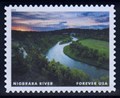
|  Niobrara River, near Valentine, NE Niobrara River, near Valentine, NE
in Philatelic Photographs The Niobrara River in northern Nebraska was one of a dozen “Wild and Scenic” rivers featured on a set of U.S. postage stamps issued in 2019. posted by: hykesj location: Nebraska date approved: 06/15/2021 last visited: never |
 view gallery view galleryN12.7 km |  US Highway 83, Valentine, NE US Highway 83, Valentine, NE
in Blue Star Memorial Highway Markers A Blue Star Highway marker near Valentine, NE, on the "Blue Star Highway". posted by:  Zaphody3k Zaphody3k location: Nebraska date approved: 10/14/2014 last visited: 06/27/2014 |
 view gallery view galleryN16.7 km |  South Dakota/Nebraska along US 83 South Dakota/Nebraska along US 83
in Border Crossings Border between South Dakota and Nebraska on US Highway 83. posted by: Zaphody3k location: Nebraska date approved: 10/15/2014 last visited: 06/27/2014 |
 view gallery view gallery E17.2 km E17.2 km
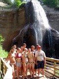
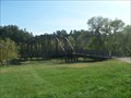
|  Smith Falls Smith Falls
in Waterfalls Waterfalls in Nebraska? Yes, there really are some and Smith Falls is the tallest. It's easily accessible on foot when either parking at the Visitor Center, the campground or when canoeing down the Niobrara River. The walkway to the falls is also wheelchair accessible, so everyone can enjoy the beauty of nature in this park. posted by: DakotaGeek location: Nebraska date approved: 01/29/2006 last visited: 07/12/2009 |
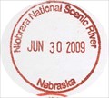 view gallery view galleryE17.4 km |  Niobrara National Wild and Scenic River Niobrara National Wild and Scenic River
in NPS Passport Cancellation Stations The Niobrara National Scenic River flows through north central Nebraska and features varied wildlife, geographic features, excellent canoing and many scenic waterfalls. posted by: The WBs location: Nebraska date approved: 04/27/2011 last visited: 06/30/2009 |
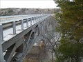
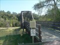 view gallery view galleryE17.4 km | Verdigre Bridge, Niobrara Scenic River, Valentine, NE in Nebraska Historical Markers Truss Bridge provides pedestrian access to the Smith Falls across the Niobrara River. posted by: plainsdrifter358 location: Nebraska date approved: 06/05/2008 last visited: never |
 view gallery view galleryE17.4 km |  Verdigre Bridge, Niobrara Scenic River, Valentine, NE Verdigre Bridge, Niobrara Scenic River, Valentine, NE
in Orphaned Bridges Truss Bridge provides pedestrian access to the Smith Falls across the Niobrara River. Previously located across the Verdigre Creek near the town of Verdigre, NE knows as the Verdigre Creek Bridge. posted by: plainsdrifter358 location: Nebraska date approved: 06/09/2008 last visited: never |
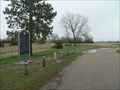
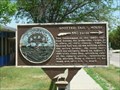 view gallery view galleryNW50.1 km |  Spotted Tail's House Spotted Tail's House
in South Dakota Historical Markers Spotted Tail's house Historical Marker in Rosebud, SD posted by: plainsdrifter358 location: South Dakota date approved: 06/08/2006 last visited: 05/28/2006 |
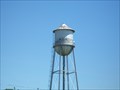 view gallery view galleryN50.5 km |  Watertower, Antelope, South Dakota Watertower, Antelope, South Dakota
in Water Towers Small community watertower. posted by: NGComets location: South Dakota date approved: 07/27/2011 last visited: never |
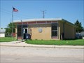 view gallery view galleryN51.5 km |  Mission, South Dakota 57555 Mission, South Dakota 57555
in U.S. Post Offices Postoffice in a small town on the Rosebud Reservation. posted by: NGComets location: South Dakota date approved: 07/30/2011 last visited: never |
 view gallery view gallery SE52.6 km SE52.6 km
| Lakeland Sod High School in Nebraska Historical Markers Nebraska prairie sod is used to build a High School in 1924. posted by: plainsdrifter358 location: Nebraska date approved: 06/02/2008 last visited: 05/08/2008 |
 view gallery view gallerySE53.3 km | Ainsworth Army Air Field in Nebraska Historical Markers One of eleven training bases in Nebraska during World War II. posted by: plainsdrifter358 location: Nebraska date approved: 05/11/2008 last visited: 07/27/2009 |
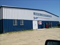 view gallery view galleryN57.6 km | Okreek, South Dakota 57563 in U.S. Post Offices A post office sharing space with a community center. posted by: NGComets location: South Dakota date approved: 07/30/2011 last visited: never |
 view gallery view galleryN57.6 km | Chauncey Eaglehorn War Memorial in South Dakota Historical Markers Eaglehorn WWI Memorial Stone along US Hwy 18 in Okreek, SD posted by: plainsdrifter358 location: South Dakota date approved: 06/08/2006 last visited: 05/28/2006 |
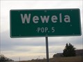 view gallery view galleryE62.9 km |  Wewela, South Dakota - Population 5 Wewela, South Dakota - Population 5
in Population Signs Small town near the SD/NE border. Elevation 2126. posted by: NGComets location: South Dakota date approved: 12/11/2017 last visited: never |
 view gallery view galleryE63.1 km |  Mt. Hope Cemetery, Springview, Nebraska Mt. Hope Cemetery, Springview, Nebraska
in Worldwide Cemeteries Located just south of Springview, NE, along US Hwy 385.
Elevation 2427. posted by: NGComets location: Nebraska date approved: 12/13/2017 last visited: never |
|