 view gallery view gallery W0.3 km W0.3 km
|   Al Capp - Amesbury, MA Al Capp - Amesbury, MA
in Grave of a Famous Person Grave of humorist and cartoonist Al Capp, creator of the long-running comic strip Li’l Abner. posted by:  hykesj hykesj location: Massachusetts date approved: 12/09/2022 last visited: never |
 view gallery view gallery S1 km S1 km
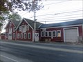
|  Lowell’s Boat Shop - Amesbury, MA Lowell’s Boat Shop - Amesbury, MA
in U.S. National Register of Historic Places This living history museum helps preserve the art of boatbuilding. posted by:  wildernessmama wildernessmama location: Massachusetts date approved: 05/12/2017 last visited: never |
 view gallery view gallery SW1.1 km SW1.1 km
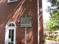
|  Macy-Colby House Macy-Colby House
in Massachusetts Historical Markers The original house built in 1654 was torn down around 1712 and by 1745 the present day saltbox-style house had been built by Obadiah Colby. The house remained in the Colby family for nine generations. posted by: MrsMcFly location: Massachusetts date approved: 08/25/2009 last visited: 11/02/2020 |
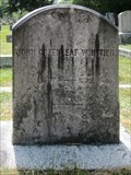 view gallery view galleryW1.3 km | John Greenleaf Whittier - Amesbury, MA in Grave of a Famous Person Grave of prominent 19th century American author, poet, editor and abolitionist, John Greenleaf Whittier. posted by: hykesj location: Massachusetts date approved: 10/25/2023 last visited: never |
 view gallery view gallery NW1.4 km NW1.4 km
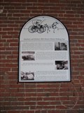
| Amesbury and Salisbury Mills Historic District Walking Tour in Massachusetts Historical Markers In a nice walkway along the Powwow River in the center of Amesbury and surrounded by the old brick mills, there are a set of signs that highlight features and history there. posted by: NorStar location: Massachusetts date approved: 08/01/2008 last visited: never |
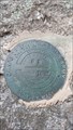
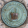 view gallery view galleryNW1.4 km |  Town of Amesbury Town of Amesbury
in U.S. Benchmarks Round bronze marker stamped with "Town of Amesbury Bench Mark 41". There is a raised square near the center of the benchmark. posted by: yukionna location: Massachusetts date approved: 08/03/2008 last visited: never |
 view gallery view gallerySW2.4 km | Susanna North Martin Homestead in Massachusetts Historical Markers Rock noting spot of Susanna Martin's house. posted by: ScuffyJ location: Massachusetts date approved: 10/10/2013 last visited: 08/07/2019 |
 view gallery view gallerySW2.4 km | Maudslay State Park - Corps of Engineers - U.S. Army Survey Mark (1987) - Station Designation R2 in U.S. Benchmarks Maudslay State Park Benchmark - Corps of Engineers - U.S. Army Survey Mark (1987) - Station Designation R2
Found on a rock located on the coast of the Merrimack River in Maudslay State Park, Newburyport, MA posted by: LadyChelzor location: Massachusetts date approved: 06/10/2016 last visited: never |
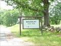 view gallery view galleryS3.2 km |  Maudslay State Park - Newburyport, MA Maudslay State Park - Newburyport, MA
in State/Provincial Parks Located on Curzon Mill Rd in Newburyport, MA posted by: nomadwillie location: Massachusetts date approved: 06/11/2010 last visited: 11/24/2015 |
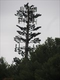 view gallery view gallery E3.9 km E3.9 km
|  Pine Tree Cell Tower - Salisbury, MA Pine Tree Cell Tower - Salisbury, MA
in Disguised Cell Towers Pine tree tower visible from Lafyette Road north of Salisbury, MA posted by: uccacher location: Massachusetts date approved: 11/15/2011 last visited: 06/29/2015 |
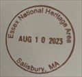 view gallery view gallery NE4.2 km NE4.2 km
|  Essex National Heritage Area - Salisbury, MA Essex National Heritage Area - Salisbury, MA
in NPS Passport Cancellation Stations A stop in the Essex National Heritage Area posted by: chrissyml location: Massachusetts date approved: 08/19/2023 last visited: never |
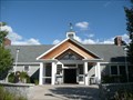
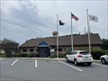 view gallery view galleryNE4.2 km |  Maria Miles Visitor Information Center - Salisbury, MA Maria Miles Visitor Information Center - Salisbury, MA
in Tourist Information Centers - Visitor Centers A tourist information center on the MA/NH border posted by: chrissyml location: Massachusetts date approved: 08/15/2023 last visited: never |
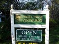 view gallery view galleryNW4.2 km |  Jewell Towne Vineyards Jewell Towne Vineyards
in Wineries Jewell Towne Vineyards. posted by: Phatdog1 location: Massachusetts date approved: 09/07/2006 last visited: never |
 view gallery view galleryNE4.5 km |  NH/MA on I-95 NH/MA on I-95
in Border Crossings A border crossing on I-95 between Massachusetts and New Hampshire. posted by: PeterNoG location: New Hampshire date approved: 11/30/2010 last visited: 07/01/2014 |
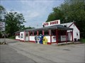 view gallery view galleryE4.7 km | Ann's Diner - Salisbury MA in U.S. National Register of Historic Places Also known as Pat's Diner; Norm's Place. It is an example of a diner built by the Worcester Lunch Car company. posted by: nomadwillie location: Massachusetts date approved: 06/10/2010 last visited: 09/15/2018 |
 view gallery view galleryE4.7 km |  Ann's Diner - Salisbury MA Ann's Diner - Salisbury MA
in Wikipedia Entries Also known as Pat's Diner; Norm's Place. It is an example of a diner built by the Worcester Lunch Car company. posted by: nomadwillie location: Massachusetts date approved: 06/10/2010 last visited: 09/25/2017 |
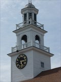 view gallery view galleryE4.7 km |  United Methodist Clock - Salisbury MA United Methodist Clock - Salisbury MA
in Town Clocks Located at 8 Lafayette Road, Salisbury, MA? posted by: nomadwillie location: Massachusetts date approved: 06/12/2010 last visited: 09/15/2018 |
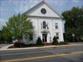 view gallery view galleryE4.8 km |  Salisbury, MA Salisbury, MA
in City and Town Halls Located at 5 Beach Road, Salisbury, MA? posted by: nomadwillie location: Massachusetts date approved: 06/15/2010 last visited: 05/30/2010 |
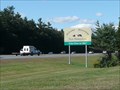
 view gallery view galleryNE4.8 km |  New Hampshire Welcome Center - I-95 New Hampshire Welcome Center - I-95
in Highway Rest Areas This welcome center is on I-95 northbound just north of the Massachusetts border. posted by: PeterNoG location: New Hampshire date approved: 11/30/2010 last visited: 08/10/2023 |
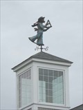 view gallery view galleryNE4.8 km |  Mariner with Sextant Weathervane Mariner with Sextant Weathervane
in Unique Weathervanes Sailor holding a sextant. posted by: Prying Pandora location: New Hampshire date approved: 05/21/2008 last visited: 10/15/2021 |
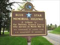 view gallery view galleryNE5 km |  Northbound I-95 , Seabrooke, New Hampshire Northbound I-95 , Seabrooke, New Hampshire
in Blue Star Memorial Highway Markers In a rest stop on northbound I-95 posted by: Prying Pandora location: New Hampshire date approved: 05/21/2008 last visited: 06/22/2018 |
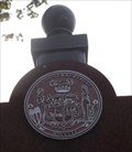 view gallery view gallery SE5.3 km SE5.3 km
|  City Coat of Arms - Newburyport, MA City Coat of Arms - Newburyport, MA
in Coats of Arms In 1851, ordinance No. 14 established the City Coat of Arms of Newburyport. posted by:  neoc1 neoc1 location: Massachusetts date approved: 08/02/2011 last visited: 10/23/2016 |
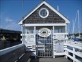 view gallery view gallerySE5.3 km |  Newburyport Marinas - Windward Yacht Yard - Newburyport, MA Newburyport Marinas - Windward Yacht Yard - Newburyport, MA
in Marinas The Windward Yacht Yard along with the Newburyport Harbor Marina, the Hilton's Marina, and the Newburyport Boat Basin comprise the Newburyport Marinas on the Merrimack River in Newburyport. posted by: neoc1 location: Massachusetts date approved: 08/13/2011 last visited: 09/25/2017 |
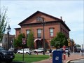 view gallery view gallerySE5.6 km | Newburyport, MA in City and Town Halls Located at 60 Pleasant Street, Newburyport, MA? posted by: nomadwillie location: Massachusetts date approved: 06/15/2010 last visited: 05/30/2010 |
 view gallery view gallerySE5.6 km | Watts' Cellar in Massachusetts Historical Markers Marker located on Merrimac Street in downtown Newburyport, MA posted by: MrsMcFly location: Massachusetts date approved: 08/25/2009 last visited: never |
|