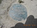
 view gallery view gallery NE0.5 km NE0.5 km
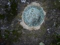
|   Fort Devens Sweet Heart Memorial Disk Fort Devens Sweet Heart Memorial Disk
in U.S. Benchmarks Military Reservation
BM A3 posted by:  trainlove trainlove location: Massachusetts date approved: 02/14/2009 last visited: 11/13/2023 |
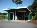 view gallery view galleryNE1 km |  VeriZon payphone at Devens Information Center - Ayer, MA VeriZon payphone at Devens Information Center - Ayer, MA
in Payphones VeriZon payphone at Devens Information Center - Ayer, MA posted by: king.hubi location: Massachusetts date approved: 05/27/2009 last visited: never |
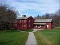
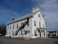
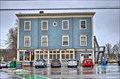
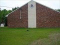 view gallery view galleryNE1.8 km |  Caleb Butler Lodge, AF & AM Caleb Butler Lodge, AF & AM
in Masonic Temples Caleb Butler Lodge, located at 11 Sculley Rd., Ayer, MA posted by:  gkromer gkromer location: Massachusetts date approved: 03/17/2008 last visited: 03/17/2008 |
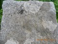
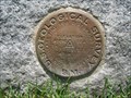 view gallery view galleryNE2.7 km | USGS - B240 1922 - Ayer, MA in U.S. Benchmarks A bench mark disk from the U.S. Geological Survey (USGS) located in the Town of Ayer, Massachusetts along Main Street (aka Route 111) set vertically into the first corner stone of the south-east corner of the Ayer Town Hall facing south. posted by: king.hubi location: Massachusetts date approved: 06/04/2010 last visited: 11/13/2023 |
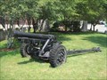 view gallery view galleryNE2.7 km |  105 mm Howitzer M3 - Ayer, MA 105 mm Howitzer M3 - Ayer, MA
in Static Artillery Displays This 105 mm Howitzer M3 is on public display at the Town Hall in Ayer, Massachusetts. posted by: king.hubi location: Massachusetts date approved: 06/08/2010 last visited: never |
 view gallery view galleryNE2.9 km |  Ayer District Court - Ayer MA Ayer District Court - Ayer MA
in Courthouses Located on Main St directly across from the Ayer Library posted by: nomadwillie location: Massachusetts date approved: 11/09/2015 last visited: never |
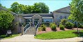 view gallery view galleryNE2.9 km |  Ayer Library - Ayer MA Ayer Library - Ayer MA
in Libraries Locaed on East Main St across from the District Court. posted by: nomadwillie location: Massachusetts date approved: 07/19/2015 last visited: never |
 view gallery view gallery SE3.1 km SE3.1 km
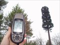
|  Harvard Tree Tower Harvard Tree Tower
in Disguised Cell Towers A suspicious tree I spotted from Route 2. posted by: mrducky location: Massachusetts date approved: 05/05/2007 last visited: never |
 view gallery view gallery S4 km S4 km
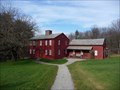
|  Fruitlands - Harvard, MA Fruitlands - Harvard, MA
in U.S. National Register of Historic Places Fruitlands was a Utopian agrarian commune established in Harvard, Massachusetts by Amos Bronson Alcott and Charles Lane in the 1840s, based on Transcendentalist principles.
posted by: nomadwillie location: Massachusetts date approved: 11/26/2009 last visited: 08/20/2017 |
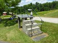 view gallery view galleryS4 km |  Wagon Mounting Steps and Platform - Harvard, MA Wagon Mounting Steps and Platform - Harvard, MA
in Historic Upping Stones, Hitching Posts, and Carriage Blocks Wagon Mounting Steps and Platform are located on the grounds of Fruitlands Museum in Harvard, MA. posted by:  neoc1 neoc1 location: Massachusetts date approved: 09/12/2017 last visited: never |
 view gallery view galleryS4 km |  Wo-Peen - Harvard, MA Wo-Peen - Harvard, MA
in Statues of Historic Figures The statue of Wo-Peen, born Louis Gonzales, is located on the grounds of the Fruitlands Museum, 102 Prospect Hill Road, Harvard, MA. posted by: neoc1 location: Massachusetts date approved: 07/14/2014 last visited: never |
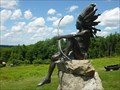
 view gallery view galleryS4 km |  Pumunangwet (He Who Shoots The Stars) - Harvard, MA Pumunangwet (He Who Shoots The Stars) - Harvard, MA
in Figurative Public Sculpture The sculpture Pumunangwet (He Who Shoots The Stars) is located on the grounds of the Fruitlands Museum, 102 Prospect Hill Road, Harvard, MA posted by: neoc1 location: Massachusetts date approved: 07/15/2014 last visited: never |
 view gallery view galleryS4.2 km | Fruitlands Museums Historic District - Harvard MA in U.S. National Register of Historic Places Fruitlands Museum is a cluster of small historic buildings in Harvard, Massachusetts on the former site of the unsuccessful utopian community Fruitlands. posted by: nomadwillie location: Massachusetts date approved: 11/26/2009 last visited: 08/20/2017 |
 view gallery view galleryS4.2 km |  Fruitlands (transcendental center) - Harvard MA Fruitlands (transcendental center) - Harvard MA
in Wikipedia Entries Fruitlands was a Utopian agrarian commune established in Harvard, Massachusetts by Amos Bronson Alcott and Charles Lane in the 1840s, based on Transcendentalist principles. posted by: nomadwillie location: Massachusetts date approved: 12/08/2009 last visited: 08/20/2017 |
 view gallery view galleryS4.5 km | NGS PID# MY3811 - SEARS 1935 in U.S. Benchmarks NGS PID# MY3811 - SEARS 1935 posted by: Ganuman location: Massachusetts date approved: 09/20/2011 last visited: 11/13/2023 |
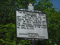 view gallery view gallery NW5.3 km NW5.3 km
|  The Revolutionary Tavern The Revolutionary Tavern
in Massachusetts Historical Markers This historical marker about The Revolutionary Tavern is located along route 2A in Shirley, Massachusetts. You'll find the marker north of the intersection of Great Road (Route 2A) and Parker Road. posted by: king.hubi location: Massachusetts date approved: 06/01/2009 last visited: 02/18/2011 |
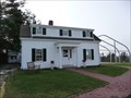
 view gallery view gallerySE5.3 km |  Harvard, MA Harvard, MA
in City and Town Halls Harvard Town Hall is located at 13 Ayer Rd, Harvard Twn, MA 01451
posted by: nomadwillie location: Massachusetts date approved: 11/26/2009 last visited: 11/21/2009 |
 view gallery view galleryS5.5 km | MHD PID# 17682 in U.S. Benchmarks STATION 448 posted by: Ganuman location: Massachusetts date approved: 07/17/2011 last visited: never |
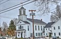
 view gallery view gallerySE5.5 km |  Congregational Church of Harvard, UCC - Harvard MA Congregational Church of Harvard, UCC - Harvard MA
in This Old Church Historic church built in 1821 formed due to a split between the Unitarians and Trinitarians. posted by: nomadwillie location: Massachusetts date approved: 01/15/2014 last visited: never |
 view gallery view gallerySE5.5 km |  Harvard Evangelical Congregational Church - Harvard Center Historic District - Harvard MA Harvard Evangelical Congregational Church - Harvard Center Historic District - Harvard MA
in NRHP Historic Districts - Contributing Buildings Historic church built in 1821 formed due to a split between the Unitarians and Trinitarians. posted by: nomadwillie location: Massachusetts date approved: 01/15/2014 last visited: never |
 view gallery view gallerySE5.5 km | Harvard Center Historic District - Harvard MA in U.S. National Register of Historic Places Harvard was founded in 1732 and early life centered around the town commons. posted by: nomadwillie location: Massachusetts date approved: 01/12/2014 last visited: never |
 view gallery view gallerySE5.5 km | Gale and Dickson Store - Harvard Center Historic District - Harvard MA in NRHP Historic Districts - Contributing Buildings Historic store built in 1896 posted by: nomadwillie location: Massachusetts date approved: 01/15/2014 last visited: never |
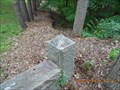
 view gallery view galleryS5.6 km | HARVARD-LANCASTER TOWN LINE MONUMENT in U.S. Benchmarks CHISELED SQUARE
ELEVATION - 235.47' posted by: Ganuman location: Massachusetts date approved: 07/17/2011 last visited: never |
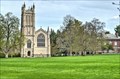 view gallery view galleryNE5.8 km | St John's Chapel - The Groton School - Groton MA in This Old Church Located just inside the gates to the Groton School on Farmers Row in Groton MA posted by: nomadwillie location: Massachusetts date approved: 05/12/2014 last visited: never |
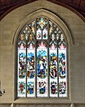 view gallery view galleryNE5.8 km |  St John's Chapel - The Groton School - Groton MA St John's Chapel - The Groton School - Groton MA
in Stained Glass Windows St John's Chapel is located on The Groton School campus just as you enter the grounds from Farmers Row posted by: nomadwillie location: Massachusetts date approved: 05/14/2014 last visited: never |
|