 view gallery view gallery SW0.2 km SW0.2 km
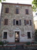
|   Les Cluses - France Les Cluses - France
in City and Town Halls Les Cluses is located in the canton of Vallespir-Albères and in the arrondissement of Céret. posted by:  superstein superstein location: Occitanie, France date approved: 09/16/2022 last visited: never |
 view gallery view gallery SE0.5 km SE0.5 km
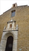
|  Fortifications romaines - Les Cluses (Pyrénées-Orientales), France Fortifications romaines - Les Cluses (Pyrénées-Orientales), France
in Ancient Roman Civilization [FR] Le site est composé de deux ensembles de fortifications romaines situées en surplomb de la Via Domitia. [EN] Along the river of Rome, the Via Domitia is dominated on both sides by Roman forts dating from the 2nd and 4th centuries posted by: RakeInTheCache location: Occitanie, France date approved: 05/12/2022 last visited: never |
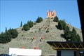
 view gallery view gallerySE2.3 km |  La pyramide - Col du Perthus, Languedoc-Roussillon, France La pyramide - Col du Perthus, Languedoc-Roussillon, France
in Wikipedia Entries The French side of the pass, with the Pyramid of Perthus to the right. posted by: Team Glandouillage location: Occitanie, France date approved: 09/25/2017 last visited: 09/25/2017 |
 view gallery view gallerySE2.3 km |  Les marches qui accède au monument frontalier - Le Perthus, Languedoc-Roussillon, France Les marches qui accède au monument frontalier - Le Perthus, Languedoc-Roussillon, France
in Outdoor Stairways [EN] The Franco-Spanish border: on the French Highway A9 and the AP-7 Motorway on the Spanish side. posted by: Team Glandouillage location: Occitanie, France date approved: 09/23/2017 last visited: 09/25/2017 |
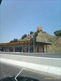 view gallery view gallerySE2.3 km |  Pyramid, Le Catalane, E15, France/Spain border Pyramid, Le Catalane, E15, France/Spain border
in Pyramids A pyramid situated just over the France/Spain frontier on the North bound carriageway of the E15/A9 posted by: SMacB location: Occitanie, France date approved: 06/11/2013 last visited: 10/26/2009 |
 view gallery view gallery NW2.4 km NW2.4 km
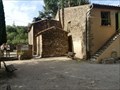
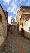
|  Església de Sant Martí de Fonollar, Morellàs i les Illes - France Església de Sant Martí de Fonollar, Morellàs i les Illes - France
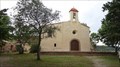
in This Old Church The Saint-Martin-de-Fenollar chapel (Sant Marti de Fenollar in Catalan) is a pre-Roman chapel located in Maureillas-las-Illas in the Pyrénées-Orientales département. It is celebrated for the splendid Roman frescoes, dates from the XIIe century, posted by: superstein location: Occitanie, France date approved: 10/22/2021 last visited: never |
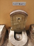 view gallery view galleryNW2.4 km |  Església de Sant Martí de Fonollar, Morellàs i les Illes - France Església de Sant Martí de Fonollar, Morellàs i les Illes - France
in Converted Fountains Fountain on the wall of the chapel posted by: superstein location: Occitanie, France date approved: 07/13/2022 last visited: never |
 view gallery view gallery W2.7 km W2.7 km
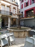
|  Fountain Maureillas - France Fountain Maureillas - France
in Fountains Fountain in the center of Maureillas posted by: superstein location: Île-de-France, France date approved: 11/30/2021 last visited: never |
 view gallery view galleryW2.7 km |  Little Free Library - Maureillas-Las-Illas, France Little Free Library - Maureillas-Las-Illas, France
in Free Community Book Exchanges Small public library in the center of Maureillas. posted by: superstein location: Occitanie, France date approved: 12/24/2021 last visited: 07/18/2023 |
 view gallery view gallerySE3.7 km |  Spain (La Jonquera) - France (Le Perthus), by urban street Spain (La Jonquera) - France (Le Perthus), by urban street
in Border Crossings [EN] The Franco-Spanish border that crosses Av. of Perthus on the D900 and Av. Catalunya on the N-II on the Spanish side. posted by: Team Glandouillage location: Cataluña, Spain date approved: 09/21/2017 last visited: 01/10/2023 |
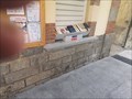
 view gallery view gallery S3.7 km S3.7 km
| France/Spanish Border - Lloc arqueològic de Panissars in Border Crossings Big borderstone (number 567) on de border between France ans Spain. posted by: superstein location: Occitanie, France date approved: 11/30/2021 last visited: never |
 view gallery view gallery N4.2 km N4.2 km
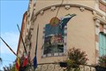
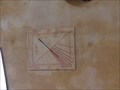
|  Old Maire office, Le Boulou, Languedoc-Roussillon, France Old Maire office, Le Boulou, Languedoc-Roussillon, France
in Sundials A nice painted sundial on the old Maire building in Le Boulou posted by: GeoRams location: Occitanie, France date approved: 10/05/2014 last visited: never |
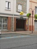 view gallery view galleryN4.3 km |  La Poste Le Boulou - France La Poste Le Boulou - France
in European Post Offices The postoffice is located at 31 Av. du Gén de Gaulle
66160 Le Boulou posted by: superstein location: Occitanie, France date approved: 07/12/2022 last visited: never |
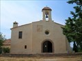
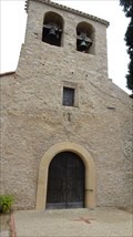 view gallery view galleryNW4.5 km | Saint-Jean de Saint-Jean-Pla-de-Corts - France in This Old Church The Church of Saint-Jean de Saint-Jean-Pla-de-Corts is a partly Romanesque church located in Saint-Jean-Pla-de-Corts, in the French department of Pyrénées-Orientales posted by: superstein location: Occitanie, France date approved: 02/17/2022 last visited: never |
 view gallery view galleryW7.4 km | The Saint-Pierre church - Ceret - France in This Old Church The Saint-Pierre church of Céret, in the Pyrénées-Orientales, 30 km south-west of Perpignan, is located in the historic center of the town. posted by: superstein location: Occitanie, France date approved: 02/18/2022 last visited: 01/07/2023 |
 view gallery view gallerySE7.7 km |  DC6 - L'avió de l'Albera - Catalunya, Spain DC6 - L'avió de l'Albera - Catalunya, Spain
in Plane Crash Sites Un avió impresionant posted by:  Galleda Galleda location: Spain date approved: 03/25/2008 last visited: 01/10/2023 |
 view gallery view galleryNW7.7 km |  Sant Miquel de Vivers. - France Sant Miquel de Vivers. - France
in Town Clocks Clock in the tower of Sant Miquel de Vivers. posted by: superstein location: Occitanie, France date approved: 05/18/2023 last visited: never |
 view gallery view galleryNW7.7 km | Sant Miquel de Vivers - Vivers - France in Roman Catholic Churches Sant Miquel de Vivers is the parochial church of Poble Rossellonès de Vivers, in North Catalonia. It is located in the center and highest point of the hill where the town is located, next to the place where the Castell de Vivers used to be posted by: superstein location: Occitanie, France date approved: 05/23/2023 last visited: never |
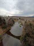 view gallery view galleryW7.9 km |  Pont Du Diable Pont Du Diable
in Arch Bridges The Pont du Diable or Pont Vieux is a medieval stone arch bridge at Céret, France. posted by: Atrellu location: Occitanie, France date approved: 01/13/2023 last visited: never |
 view gallery view galleryS8.4 km | Museu Memorial de l'Exilil, La Jonquera, Spain in Wikipedia Entries The Exile Memorial Museum (MUME) is a place for memory, history and critical reflection. posted by: Team Glandouillage location: Cataluña, Spain date approved: 01/14/2016 last visited: 01/14/2016 |
 view gallery view galleryNW8.5 km | Ermitage Sant Ferriol, near Ceret, Languedoc-Roussillon, France in Sundials The Hermitage of St Ferreol is 5 kms North East of Ceret on the river Tech. 300m altitude. posted by: GeoRams location: Occitanie, France date approved: 10/11/2014 last visited: never |
 view gallery view galleryNW8.5 km | Hermitage Saint-Ferréol de Céret - France in This Old Church The Ermitage Saint-Ferréol (in Catalan and on the IGN map: Sant Ferriol) is a chapel dedicated to Saint Ferréol in Céret (Pyrénées-Orientales). Built in the XIII th century on pre-Romanesque bases, it was rebuilt in the XVIII th century. posted by: superstein location: Occitanie, France date approved: 02/18/2022 last visited: never |
 view gallery view galleryNW8.5 km |  St Ferréol Hermitage, Céret, France St Ferréol Hermitage, Céret, France
in Medieval Churches The St Ferréol Hermitage is a simple chapel built in the XIII century on the side of Mt Canigou, above the town of Céret, France. Here are the relics of St Ferréol, a martyr in 304. posted by: arby101ca location: France date approved: 04/28/2010 last visited: never |
 view gallery view galleryW8.7 km |  Gare de Céret (former) - France Gare de Céret (former) - France
in Train Stations/Depots Céret station is a closed French railway station on the line from Elne to Arles-sur-Tech, located on the territory of the municipality of Céret, in the Pyrénées-Orientales department, in the Occitanie administrative region. posted by: superstein location: Occitanie, France date approved: 07/13/2022 last visited: never |
 view gallery view gallery E8.9 km E8.9 km
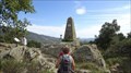
|  Puig Neulós - Highest Point of "Serra de l'Albera" Puig Neulós - Highest Point of "Serra de l'Albera"
in Geographic High Points El Puig neulós és el pic més alt de la serra de l'Albera, amb 1256m d'alçada posted by: Galleda location: Spain date approved: 03/24/2008 last visited: 09/06/2015 |
|