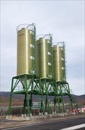
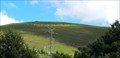
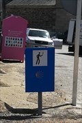
 view gallery view gallery E8.7 km E8.7 km
|   A-52 Km107 – Lubián, Zamora, España A-52 Km107 – Lubián, Zamora, España
in Solitary Silos Tres silos de vialidad invernal // Three winter road silo posted by:  xeocach xeocach location: Castilla y León, Spain date approved: 03/27/2023 last visited: never |
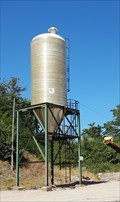 view gallery view gallery W9.3 km W9.3 km
| N-525 Km 131 - A Gudiña, Ourense, España in Solitary Silos Silo de vialidad invernal // Winter road silo posted by: xeocach location: Galicia, Spain date approved: 07/27/2023 last visited: never |
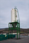 view gallery view galleryW9.8 km | OU-533 Km0,3 – A Gudiña, Ourense, España in Solitary Silos Silo de vialidad invernal // Winter road silo posted by: xeocach location: Galicia, Spain date approved: 03/27/2023 last visited: never |
 view gallery view galleryW10 km |  N42º 03’ 38,3’’ W7º 08’ 20,4’’ - A Gudiña, Ourense, España N42º 03’ 38,3’’ W7º 08’ 20,4’’ - A Gudiña, Ourense, España
in Permanent Geographic Coordinates Marca de nivel en la fachada de la Casa Consistorial con Coordenadas Geográficas Permanentes grabadas // Level mark on the facade of the Town Hall with Permanent Geographic Coordinates posted by: xeocach location: Galicia, Spain date approved: 04/01/2023 last visited: never |
 view gallery view galleryW10 km |  A Gudiña - Ourense, España A Gudiña - Ourense, España
in Vértices Geodésicos Punto de referencia en la fachada de la Casa Consistorial con Coordenadas Geográficas Permanentes grabadas // Benchmark on the facade of the Town Hall with Permanent Geographic Coordinates engraved posted by: xeocach location: Galicia, Spain date approved: 03/20/2023 last visited: never |
 view gallery view galleryW10 km |  985m - A Gudiña, Ourense, España 985m - A Gudiña, Ourense, España
in Elevation Signs Elevación sobre el nivel medio del Mediterráneo en Alicante // Elevation above the mean level of the Mediterranean Sea in Alicante posted by: xeocach location: Galicia, Spain date approved: 03/19/2023 last visited: never |
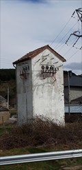
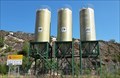 view gallery view galleryE12.4 km | A-52 Km103 – Lubián, Zamora, España in Solitary Silos Tres silos de vialidad invernal // Three winter road silo posted by: xeocach location: Castilla y León, Spain date approved: 07/27/2023 last visited: never |
 view gallery view galleryE16.1 km |  PADORNELO - Zamora, España PADORNELO - Zamora, España
in Readable From Above El nombre del pueblo a vista de pájaro // The name of the town from a bird's eye view posted by: xeocach location: Castilla y León, Spain date approved: 08/02/2023 last visited: never |
 view gallery view gallery NW17.1 km NW17.1 km
| Viana do Bolo - Ourense, España in Vértices Geodésicos Punto de referencia en la fachada de la Casa Consistorial con Coordenadas Geográficas Permanentes grabadas // Benchmark on the facade of the Town Hall with Permanent Geographic Coordinates engraved posted by: xeocach location: Galicia, Spain date approved: 03/20/2023 last visited: never |
 view gallery view galleryNW17.1 km | 715m - Viana do Bolo, Ourense, España in Elevation Signs Elevación sobre el nivel medio del Mediterráneo en Alicante // Elevation above the mean level of the Mediterranean Sea in Alicante posted by: xeocach location: Galicia, Spain date approved: 03/19/2023 last visited: never |
 view gallery view galleryNW17.1 km | N42º 10’ 49,2’’ W7º 06’ 53,2’’ -Viana do Bolo, Ourense, España in Permanent Geographic Coordinates Marca de nivel en la fachada de la Casa Consistorial con Coordenadas Geográficas Permanentes grabadas // Level mark on the facade of the Town Hall with Permanent Geographic Coordinates posted by: xeocach location: Galicia, Spain date approved: 04/01/2023 last visited: never |
 view gallery view galleryNW17.1 km |  Boteiro - Viana do Bolo, Ourense, España Boteiro - Viana do Bolo, Ourense, España
in Occupational Monuments É a figura máis emblemática do Entroido da comarca de Viana do Bolo // The boteiro is the most emblematic figure of the Carnival of the Viana do Bolo region posted by: xeocach location: Galicia, Spain date approved: 04/23/2024 last visited: never |
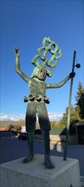 view gallery view galleryNW17.1 km |  Boteiro - Viana do Bolo, Ourense, España Boteiro - Viana do Bolo, Ourense, España
in Figurative Public Sculpture É a figura máis emblemática do Entroido da comarca de Viana do Bolo // The boteiro is the most emblematic figure of the Carnival of the Viana do Bolo region posted by: xeocach location: Galicia, Spain date approved: 04/23/2024 last visited: never |
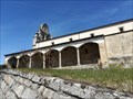
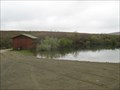 view gallery view gallery S20.1 km S20.1 km
|  Observatório Charca da Vidoeira - Vinhais, Portugal Observatório Charca da Vidoeira - Vinhais, Portugal
in Birdwatching Locations A Birdwatching Location in Vinhais. posted by:  razalas razalas location: Bragança, Portugal date approved: 05/31/2010 last visited: 05/08/2010 |
 view gallery view galleryS22 km |  Ciradelha Ciradelha
in Portugal Geodetic Points V.G. na Ciradelha em Vinhais. posted by: razalas location: Bragança, Portugal date approved: 05/31/2010 last visited: 05/31/2010 |
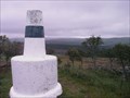
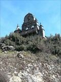
 view gallery view gallery N22.7 km N22.7 km
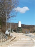
|  32CF31 - Alto do Covelo, Ourense, España 32CF31 - Alto do Covelo, Ourense, España
in Historic Transformer Sub-Stations Buildings Subestación transformadora ubicada en O Alto do Covelo // Transformer substation tower located in O Alto do Covelo posted by: xeocach location: Galicia, Spain date approved: 08/04/2023 last visited: never |
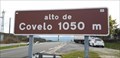 view gallery view galleryN22.7 km | 1050m - Viana do Bolo, Ourense, España in Elevation Signs Señal de elevación en O Alto do Covelo // Elevation sign at O Alto do Covelo posted by: xeocach location: Galicia, Spain date approved: 04/01/2023 last visited: never |
 view gallery view galleryE22.9 km | Silo CL - Requejo, Zamora, Castilla y León, España in Solitary Silos Silo in CL posted by: Ariberna location: Castilla y León, Spain date approved: 04/09/2022 last visited: 07/20/2023 |
 view gallery view galleryN22.9 km | N42º 15’ 00,2’’ W7º 01’ 34,0’’ - A Veiga, Ourense, España in Permanent Geographic Coordinates Marca de nivel en la fachada de la Casa Consistorial con Coordenadas Geográficas Permanentes grabadas // Level mark on the facade of the Town Hall with Permanent Geographic Coordinates posted by: xeocach location: Galicia, Spain date approved: 04/21/2023 last visited: never |
 view gallery view galleryN22.9 km | 874m - A Veiga, Ourense, España in Elevation Signs Elevación sobre el nivel medio del Mediterráneo en Alicante // Elevation above the mean level of the Mediterranean Sea in Alicante posted by: xeocach location: Galicia, Spain date approved: 04/12/2023 last visited: never |
 view gallery view galleryN22.9 km | A Veiga - Ourense, España in Vértices Geodésicos Punto de referencia en la fachada de la Casa Consistorial con Coordenadas Geográficas Permanentes grabadas // Benchmark on the facade of the Town Hall with Permanent Geographic Coordinates engraved posted by: xeocach location: Galicia, Spain date approved: 04/19/2023 last visited: never |
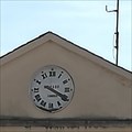 view gallery view galleryE22.9 km |  clock council - Requejo, Sanabria, Zamora, Castilla y León, España clock council - Requejo, Sanabria, Zamora, Castilla y León, España
in Town Clocks Clock of the Council posted by: Ariberna location: Castilla y León, Spain date approved: 04/10/2022 last visited: 07/20/2023 |
 view gallery view galleryE22.9 km |  Camino Santiago - Requejo, Sanabria, Zamora, Castilla y León, Camino Santiago - Requejo, Sanabria, Zamora, Castilla y León,
in Way of St. James Camino de Santiago posted by: Ariberna location: Castilla y León, Spain date approved: 04/09/2022 last visited: 04/11/2022 |
 view gallery view galleryE22.9 km |  San Lorenzo - Requejo, Sanabria, Zamora, Castilla y León, España San Lorenzo - Requejo, Sanabria, Zamora, Castilla y León, España
in Roman Catholic Churches Church of San Lorenzo posted by: Ariberna location: Castilla y León, Spain date approved: 04/10/2022 last visited: 07/20/2023 |
 view gallery view galleryE22.9 km |  San Lorenzo - Requejo, Sanabria, Zamora, Castilla y León, España San Lorenzo - Requejo, Sanabria, Zamora, Castilla y León, España
in Bell Towers Tower of the church posted by: Ariberna location: Castilla y León, Spain date approved: 04/11/2022 last visited: 07/20/2023 |
|