 view gallery view gallery SW0 km SW0 km
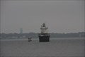
|   Butler Flats Lighthouse - New Bedford, MA Butler Flats Lighthouse - New Bedford, MA
in Wikipedia Entries This small sparkplug lighthouse is located in the New Bedford outer harbor. The lighthouse is closed to the public and is only accessible by boat. posted by:  Lat34North Lat34North location: Massachusetts date approved: 10/29/2014 last visited: 02/04/2016 |
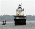
 view gallery view gallerySW0 km |  LW4927 - Butler Flats Lighthouse - New Bedford, MA LW4927 - Butler Flats Lighthouse - New Bedford, MA
in U.S. Benchmarks This small sparkplug lighthouse is located in the New Bedford outer harbor. The lighthouse is closed to the public and is only accessible by boat. posted by: Lat34North location: Massachusetts date approved: 09/02/2014 last visited: 02/04/2016 |
 view gallery view gallerySW0 km |  Butler Flats Light Station - New Bedford, MA Butler Flats Light Station - New Bedford, MA
in U.S. National Register of Historic Places This small sparkplug lighthouse is located in the New Bedford outer harbor. The lighthouse is closed to the public and is only accessible by boat. posted by: Lat34North location: Massachusetts date approved: 10/30/2014 last visited: 02/04/2016 |
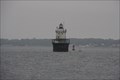 view gallery view gallerySW0 km |  Butler Flats Lighthouse - New Bedford, MA Butler Flats Lighthouse - New Bedford, MA
in Coastal Lighthouses This small sparkplug lighthouse is located in the New Bedford outer harbor. The lighthouse is closed to the public and is only accessible by boat. posted by: Lat34North location: Massachusetts date approved: 08/31/2014 last visited: 12/26/2022 |
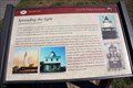 view gallery view gallerySW1.1 km |  Spreading the Light - Fort Taber Park - New Bedford, MA Spreading the Light - Fort Taber Park - New Bedford, MA
in Massachusetts Historical Markers The history of two lighthouse. Located at Fort Taber Park on S Rodney French Blvd, New Bedford, MA. posted by: Lat34North location: Massachusetts date approved: 11/07/2014 last visited: 09/04/2014 |
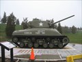 view gallery view gallerySW1.3 km |  Sherman Tank -- Fort Taber, New Bedford, Massachusetts Sherman Tank -- Fort Taber, New Bedford, Massachusetts
in Military Ground Equipment Displays A Sherman tank, honoring those who died in Exercise Tiger, a preparation for D-Day. posted by: Shorelander location: Massachusetts date approved: 05/02/2007 last visited: 02/04/2016 |
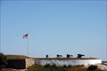
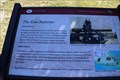 view gallery view gallerySW1.3 km | The East Batteries - Fort Taber Park - New Bedford, MA in Massachusetts Historical Markers These batteries are examples of the Endicott Taft Era (1899-1916) coastal defense installations. Located at Fort Taber Park on S Rodney French Blvd, New Bedford, MA. posted by: Lat34North location: Massachusetts date approved: 11/07/2014 last visited: 09/04/2014 |
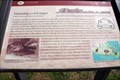
 view gallery view gallerySW1.3 km |  The East Batteries - Fort Taber Park - New Bedford, MA The East Batteries - Fort Taber Park - New Bedford, MA
in 'You Are Here' Maps This "you are here" map is part of the "East Batteries" historic marker located at Fort Taber / Fort Rodman Park in New Bedford, MA. posted by: Lat34North location: Massachusetts date approved: 11/02/2014 last visited: 09/04/2014 |
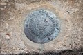
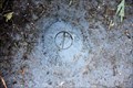 view gallery view gallerySW1.3 km | 7712 G - Fort Rodman - New Bedford, MA in U.S. Benchmarks Located in the SE Corner of the bottom step of Battery Barton Walcott NO.2, Fort Rodman Park, New Bedford, MA. posted by: Lat34North location: Massachusetts date approved: 11/03/2014 last visited: 11/04/2014 |
 view gallery view gallerySW1.3 km | LW4895 - Clarks Point Lighthouse - New Bedford, MA in U.S. Benchmarks Clarks Point Light is located on top of Fort Rodman. Fort Rodman is located at the end of Rodney French Blvd, New Bedford, MA. The area around the fort is now a park, the fort its self is NOT open to the public. posted by: Lat34North location: Massachusetts date approved: 10/29/2014 last visited: 02/04/2016 |
 view gallery view gallerySW1.3 km | Clarks Point Light - Fort Rodman - New Bedford, MA in Coastal Lighthouses Clarks Point Light is located on top of Fort Rodman. Fort Rodman is located at the end of Rodney French Blvd, New Bedford, MA. The area around the fort is now a park, the fort its self is NOT open to the public. posted by: Lat34North location: Massachusetts date approved: 10/30/2014 last visited: 05/27/2023 |
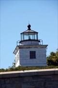 view gallery view gallerySW1.3 km | Clarks Point Light - Fort Rodman - New Bedford, MA in Wikipedia Entries Clarks Point Light is located on top of Fort Rodman. Fort Rodman is located at the end of Rodney French Blvd, New Bedford, MA. The area around the fort is now a park, the fort its self is NOT open to the public. posted by: Lat34North location: Massachusetts date approved: 10/30/2014 last visited: 02/04/2016 |
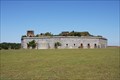 view gallery view gallerySW1.3 km | Fort Rodman - New Bedford, MA in Wikipedia Entries Fort Rodman is located at the end of Rodney French Blvd, New Bedford, MA. The area around the fort is now a park, the fort its self is NOT open to the public. posted by: Lat34North location: Massachusetts date approved: 10/29/2014 last visited: 02/04/2016 |
 view gallery view gallerySW1.3 km |  Fort Rodman - New Bedford, MA Fort Rodman - New Bedford, MA
in Historic Forts Fort Rodman is located at the end of Rodney French Blvd, New Bedford, MA. The area around the fort is now a park, the fort its self is NOT open to the public. posted by: Lat34North location: Massachusetts date approved: 11/01/2014 last visited: 02/04/2016 |
 view gallery view gallerySW1.3 km | Fort Taber District - New Bedford, MA in U.S. National Register of Historic Places Fort Taber District is located at the end of Rodney French Blvd, New Bedford, MA. The area around the fort is now a park, the fort its self is NOT open to the public. posted by: Lat34North location: Massachusetts date approved: 10/30/2014 last visited: 02/04/2016 |
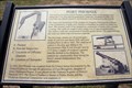
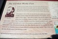 view gallery view gallerySW1.3 km | The Earthen Works Fort - Fort Taber Park - New Bedford, MA in Massachusetts Historical Markers On this site stood an earthen works fort. The exact location of the Fort is known because of the detailed drawing (right) which was rendered by Capt. Henry Martyn Robert. Located at Fort Taber Park on S Rodney French Blvd, New Bedford, MA. posted by: Lat34North location: Massachusetts date approved: 11/07/2014 last visited: 09/04/2014 |
 view gallery view gallerySW1.3 km | Defending a rich target - Fort Taber Park - New Bedford, MA in Massachusetts Historical Markers In 1840, the Army board of engineers met in Boston to plan a defense of the Atlantic Coast. Located at Fort Taber Park on S Rodney French Blvd, New Bedford, MA. posted by: Lat34North location: Massachusetts date approved: 11/07/2014 last visited: 09/04/2014 |
 view gallery view gallery S1.4 km S1.4 km
| 7712 E - Fort Rodman - New Bedford, MA in U.S. Benchmarks This station is located SE of the Fort Rodmen (the stone fort) near the sea wall. posted by: Lat34North location: Massachusetts date approved: 11/02/2014 last visited: 09/04/2014 |
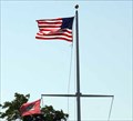 view gallery view gallery N2.4 km N2.4 km
|  Cape Code Canal Visitors Center - Sandwich, MA Cape Code Canal Visitors Center - Sandwich, MA
in Nautical Flag Poles This nautical flag pole is located in front of the Cape Code Canal Visitors Center located at the north end of the canal in Sandwich, MA. posted by: Lat34North location: Massachusetts date approved: 11/08/2014 last visited: 09/05/2014 |
 view gallery view galleryN2.4 km | Fort Phoenix - Green St, Fairhaven, MA in Massachusetts Historical Markers The shape and dimensions of the parapet are irregular, following the contours of the promontory, or high rock outcrop overlooking the harbor, on which it is built. Located at the old fort on Green St in Fairhaven, MA. posted by: Lat34North location: Massachusetts date approved: 11/07/2014 last visited: 09/04/2014 |
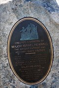 view gallery view galleryN2.4 km |  Major Israel Fearing - Fort Phoenix - Fairhaven, MA Major Israel Fearing - Fort Phoenix - Fairhaven, MA
in Specific Veteran Memorials This monument to Major Israel Fearing is located in Fort Phoenix, located on Beacon at Fort St, Fairhaven, MA. posted by: Lat34North location: Massachusetts date approved: 11/07/2014 last visited: 09/04/2014 |
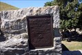
 view gallery view galleryN2.4 km | Fort Phoenix - Fairhaven, MA in Massachusetts Historical Markers This plaque is mounted to a large stone at Fort Phoenix, located on Beacon at Fort St, Fairhaven, MA. posted by: Lat34North location: Massachusetts date approved: 11/07/2014 last visited: 09/04/2014 |
 view gallery view galleryN2.4 km | Fort Phoenix - Green St, Fairhaven, MA in Massachusetts Historical Markers Fort Phoenix built for harbor defense in 1775 destroyed by the British September 6, 1778. Located at Fort Phoenix on Green St, Fairhaven, MA. posted by: Lat34North location: Massachusetts date approved: 11/07/2014 last visited: 09/04/2014 |
 view gallery view galleryN2.4 km | Fort Phoenix - Green St, Fairhaven, MA in U.S. National Register of Historic Places Fort Phoenix built for harbor defense in 1775 destroyed by the British September 6, 1778. Located on Beacon at Fort St, Fairhaven, MA. posted by: Lat34North location: Massachusetts date approved: 11/04/2014 last visited: 09/04/2014 |
 view gallery view galleryN2.4 km | Fort Phoenix - Green St, Fairhaven, MA in Wikipedia Entries Fort Phoenix built for harbor defense in 1775 destroyed by the British September 6, 1778. Located on Beacon at Fort St, Fairhaven, MA. posted by: Lat34North location: Massachusetts date approved: 11/04/2014 last visited: 09/04/2014 |
|