 view gallery view gallery S0.2 km S0.2 km
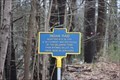
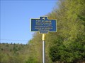
|   Indian Raid Indian Raid
in New York Historical Markers NEAR THIS SITE IN 1763
A SETTLEMENT WAS DESTROYED
BY THE DELAWARE TRIBE
FROM WYOMING VALLEY PA
THERE WERE NO SURVIVORS posted by:  rubin18 rubin18 location: New York date approved: 03/31/2019 last visited: never |
 view gallery view gallery NE0.5 km NE0.5 km
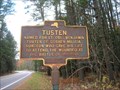
| TUSTEN in New York Historical Markers Main Street overlooks the widest eddy in the Delaware River that is frequently crisscrossed by eagles. posted by:  unimoggers unimoggers location: New York date approved: 11/03/2006 last visited: 05/06/2011 |
 view gallery view gallery NW6.4 km NW6.4 km
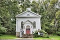
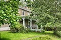
|  Narrowsburg Methodist Church - Narrowsburg NY Narrowsburg Methodist Church - Narrowsburg NY
in U.S. National Register of Historic Places Narrowsburg Methodist Church was built in 1856 and is a frame, Greek Revival style meeting house. posted by: nomadwillie location: New York date approved: 10/16/2019 last visited: never |
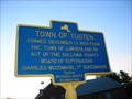 view gallery view galleryNW6.6 km | TOWN OF TUSTEN in New York Historical Markers I found this on US 97 along the Delaware River in Sullivan County, NY. I thought I had already found this, but this one is newer than the other Tusten sign. posted by: unimoggers location: New York date approved: 06/04/2007 last visited: 05/06/2011 |
 view gallery view galleryNW6.6 km | Kirk House - Narrowsburg NY in U.S. National Register of Historic Places The Kirk House was originally built as a school house in the 1840's, moved to its current location in 1875, when a second story was added. posted by: nomadwillie location: New York date approved: 10/16/2019 last visited: never |
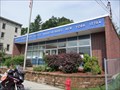 view gallery view galleryNW6.8 km |  Narrowsburg, NY 12764 Narrowsburg, NY 12764
in U.S. Post Offices Located at 75 Main Street, Narrowsburg, NY posted by: nomadwillie location: New York date approved: 06/01/2011 last visited: 08/16/2013 |
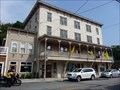 view gallery view galleryNW6.8 km | Arlington Hotel - Narrowsburg NY in U.S. National Register of Historic Places Houses the National Park Service Visitor Center for the Upper Delaware Scenic and Recreational River. posted by: nomadwillie location: New York date approved: 06/01/2011 last visited: 07/23/2010 |
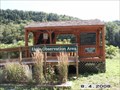
 view gallery view galleryNW6.8 km |  Upper Delaware S&RR Narrowsburg PA Upper Delaware S&RR Narrowsburg PA
in NPS Passport Cancellation Stations Rolling hills, riverfront villages, and bald eagles perched on trees form a vibrant backdrop as the Delaware River snakes gracefully through the rural countryside. posted by: nomadwillie location: Pennsylvania date approved: 11/10/2008 last visited: 02/24/2023 |
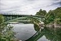 view gallery view galleryNW6.9 km |  Narrowsburg–Darbytown Bridge - Narrowsburg, NY Narrowsburg–Darbytown Bridge - Narrowsburg, NY
in Arch Bridges The Narrowsburg–Darbytown Bridge is an arch under bridge spanning the Delaware River between Darbytown, Pennsylvania and Narrowsburg, New York. posted by: nomadwillie location: New York date approved: 10/15/2019 last visited: never |
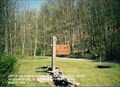
 view gallery view galleryNW7.1 km | Fort Delaware in New York Historical Markers Fort Delaware is located along scenic Route 97 in Narrowsburg, NY. If you're visiting the area on a weekend, feel free to stop by the fort and check out what life was like in the Upper Delaware Valley in 1754. posted by: lightning93 location: New York date approved: 05/10/2011 last visited: 05/11/2011 |
 view gallery view gallery N7.6 km N7.6 km
| ") Upper Delaware Scenic and Recreational River - Beach Lake PA Upper Delaware Scenic and Recreational River - Beach Lake PA
in National Parks (U.S.) The Upper Delaware Scenic and Recreational River is a unit of the National Park Service designated under the National Wild and Scenic Rivers System. It stretches along 73.4 miles (118.1 km) of the Delaware River. posted by: Don.Morfe location: Pennsylvania date approved: 02/25/2023 last visited: 02/25/2023 |
 view gallery view galleryN7.6 km |  Upper Delaware Scenic and Recreational River - Beach Lake PA Upper Delaware Scenic and Recreational River - Beach Lake PA
in National Parks of the World The Upper Delaware Scenic and Recreational River is a unit of the National Park Service designated under the National Wild and Scenic Rivers System. It stretches along 73.4 miles (118.1 km) of the Delaware River. posted by: Don.Morfe location: Pennsylvania date approved: 02/25/2023 last visited: 02/25/2023 |
 view gallery view galleryN7.6 km |  Upper Delaware Scenic and Recreational River - Beach Lake PA Upper Delaware Scenic and Recreational River - Beach Lake PA
in Official Local Tourism Attractions The Upper Delaware Scenic and Recreational River is a unit of the National Park Service designated under the National Wild and Scenic Rivers System. It stretches along 73.4 miles (118.1 km) of the Delaware River. posted by: Don.Morfe location: Pennsylvania date approved: 02/26/2023 last visited: 02/25/2023 |
 view gallery view galleryN7.6 km |  Upper Delaware Scenic and Recreational River - Beach Lake PA Upper Delaware Scenic and Recreational River - Beach Lake PA
in Ranger Stations There is a Ranger Station in the Visitor Center of the Upper Delaware Scenic and Recreational River national park. One may obtain a NPS Cancellation Stamp. posted by: Don.Morfe location: Pennsylvania date approved: 03/19/2023 last visited: 02/25/2023 |
 view gallery view galleryN7.6 km |  Upper Delaware Scenic and Recreational River - Beach Lake PA Upper Delaware Scenic and Recreational River - Beach Lake PA
in Wikipedia Entries The Upper Delaware Scenic and Recreational River is a unit of the National Park Service designated under the National Wild and Scenic Rivers System. It stretches along 73.4 miles (118.1 km) of the Delaware River. posted by: Don.Morfe location: Pennsylvania date approved: 02/24/2023 last visited: 02/24/2023 |
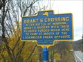 view gallery view galleryS7.9 km | BRANT'S CROSSING in New York Historical Markers Brant was perhaps the most well-known North American Indian of his generation. posted by: unimoggers location: New York date approved: 11/04/2006 last visited: 05/06/2011 |
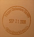 view gallery view galleryS8.2 km | Upper Delaware S&RR Zane Grey Museum in NPS Passport Cancellation Stations Rolling hills, riverfront villages, and bald eagles perched on trees form a vibrant backdrop as the Delaware River snakes gracefully through the rural countryside. But the story of the Upper Delaware is more than just a collection of beautiful pictures. We enjoy the river's recreational opportunities while it supports a healthy ecosystem for wildlife and provides water for over 17 million people.
posted by: nomadwillie location: Pennsylvania date approved: 11/10/2008 last visited: 09/21/2008 |
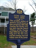 view gallery view galleryS8.2 km |  ZANE GREY ZANE GREY
in Pennsylvania Historical Markers Zane Grey lived in Lackawaxen, Pennsylvania, from 1905 until 1918. Lackawaxen always held a special place in his memories, and was chosen as the site of his final resting place. posted by: unimoggers location: Pennsylvania date approved: 11/03/2006 last visited: 04/23/2004 |
 view gallery view galleryS8.5 km | Upper Delaware SRR - New York Pennsylvania in National Parks (U.S.) Rolling hills, riverfront villages, and bald eagles perched on trees form a vibrant backdrop as the Delaware River snakes gracefully through the rural countryside. posted by: nomadwillie location: Pennsylvania date approved: 02/16/2009 last visited: 08/24/2011 |
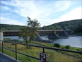
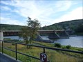 view gallery view galleryS8.5 km |  Roebling's Delaware Aqueduct - Laxawaxen PA Roebling's Delaware Aqueduct - Laxawaxen PA
in Engineering Landmarks Crosses the Delaware River between Laxawaxen PA and Minisink Ford, NY is the oldest existing wire bridge in the US. posted by: nomadwillie location: Pennsylvania date approved: 01/13/2012 last visited: never |
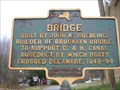 view gallery view galleryS8.7 km | BRIDGE in New York Historical Markers The Delaware Aqueduct is the oldest existing wire cable suspension bridge in the nation. Begun in 1847 as one of four suspension aqueducts on the Delaware and Hudson Canal, it was designed by and built under the supervision of John A. Roebling. posted by: unimoggers location: New York date approved: 11/04/2006 last visited: 07/07/2008 |
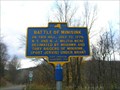
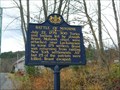 view gallery view galleryS8.7 km | BATTLE OF MINISINK in Pennsylvania Historical Markers The Battle of Minisink was the only major skirmish of the Revolutionary War fought in the northern Delaware Valley. The battle was a decisive British victory, as the colonial militia was hastily assembled, ill-equipped, and inexperienced. posted by: unimoggers location: Pennsylvania date approved: 11/04/2006 last visited: 10/23/2008 |
 view gallery view galleryS8.7 km | BATTLE OF MINISINK (ENTRANCE) in New York Historical Markers The battle was a decisive British victory, as the colonial militia was hastily assembled, ill-equipped, and inexperienced. posted by: unimoggers location: New York date approved: 11/04/2006 last visited: 07/07/2008 |
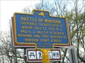
 view gallery view galleryS8.7 km | BATTLE OF MINISINK (EAST) in New York Historical Markers The Battle of Minisink was a battle of the American Revolutionary War fought at Minisink Ford, New York on July 22, 1779. It was the only major skirmish of the Revolutionary War fought in the northern Delaware Valley. posted by: unimoggers location: New York date approved: 11/04/2006 last visited: 07/07/2008 |
 view gallery view gallery SE9.5 km SE9.5 km
|  Eagle Observation Area - Barryville, NY, USA Eagle Observation Area - Barryville, NY, USA
in Birdwatching Locations A great spot for view Bald Eagles along the Delaware River. posted by: SKPnGo location: New York date approved: 09/12/2008 last visited: 08/24/2011 |
|