 view gallery view gallery N1.4 km N1.4 km
|   Trustom Pond National Wildlife Refuge - Otter Point Trail Junction - South Kingstown, RI Trustom Pond National Wildlife Refuge - Otter Point Trail Junction - South Kingstown, RI
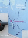
in 'You Are Here' Maps This You Are Here sign is located within the Trustom Pond National Wildlife Refuge, at a junction with a trail to a lovely viewing spot. posted by:  NorStar NorStar location: Rhode Island date approved: 01/13/2014 last visited: never |
 view gallery view gallery NW1.8 km NW1.8 km
|  Trustom Pond - South Kingstown, RI Trustom Pond - South Kingstown, RI
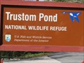
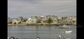
in National Wildlife Refuges Trustom Pond National Wildlife Refuge is located along a brackish pond separated from the ocean by a sand bar, where many waterfowl and predatory birds can be seen. posted by: NorStar location: Rhode Island date approved: 01/23/2014 last visited: 10/14/2016 |
 view gallery view galleryNW1.8 km |  Trustom Pond National Wildlife Refuge - South Kingstown, RI Trustom Pond National Wildlife Refuge - South Kingstown, RI
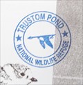
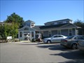
in National Public Lands Passport Locations The passport stamp is located in the visitor station of the refuge. posted by: NorStar location: Rhode Island date approved: 03/21/2014 last visited: 10/14/2016 |
 view gallery view galleryN2.1 km |  Samuel E. Perry Mill - South Kingstown, RI Samuel E. Perry Mill - South Kingstown, RI
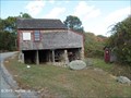
in U.S. National Register of Historic Places The grist mill in located by a small brook near the south coastal shore, built in 1703 and moved here in 1825, still grinds corn for johnnycake meal. posted by: NorStar location: Rhode Island date approved: 01/16/2014 last visited: 10/14/2016 |
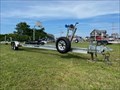 view gallery view gallery E5.1 km E5.1 km
|  Basketball Court at Succotash Road - Jerusalem, Rhode Island Basketball Court at Succotash Road - Jerusalem, Rhode Island
in Outdoor Basketball Courts This is the second-most inconvenient and/or ridiculous basketball court I've found to date, not for its location but rather for the playing area's amusing conditions. posted by:  401Photos 401Photos location: Rhode Island date approved: 08/20/2021 last visited: never |
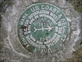 view gallery view galleryN5.1 km |  BROAD HILL AZ MK - Rhode Island BROAD HILL AZ MK - Rhode Island
in Azimuth Benchmarks This is the azimuth mark for station BROAD HILL RESET, in South Kingstown, Washington County. posted by: shorbird location: Rhode Island date approved: 06/14/2010 last visited: never |
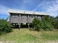 view gallery view galleryE5.1 km |  D.E.M. Fish and Wildlife Marine Fisheries Coastal Lab - Jerusalem, Rhode Island D.E.M. Fish and Wildlife Marine Fisheries Coastal Lab - Jerusalem, Rhode Island
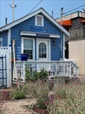
in Elevated Buildings The Rhode Island Department of Environmental Management (D.E.M.) Fish and Wildlife Marine Fisheries Coastal Lab in Jerusalem, Rhode Island is built on stilts. posted by: 401Photos location: Rhode Island date approved: 09/23/2021 last visited: never |
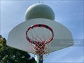 view gallery view gallery NE5.1 km NE5.1 km
| Basketball Court at Brousseau Park - South Kingstown, Rhode Island in Outdoor Basketball Courts A giant green orb stands guard over the basketball court at Brousseau Park in South Kingstown, Rhode Island. posted by: 401Photos location: Rhode Island date approved: 08/20/2021 last visited: never |
 view gallery view galleryE5.1 km |  Jerusalem, Rhode Island Jerusalem, Rhode Island
in Names From the Bible Named for the city sacred to many religions including Judaism, Islam, and Christianity, this tiny village of Jerusalem is in southern Rhode Island. Jerusalem, or Yerushalayim, appears in the Tanakh (Hebrew Bible) 669 times. posted by: 401Photos location: Rhode Island date approved: 10/16/2021 last visited: never |
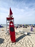
 view gallery view galleryE5.3 km |  Nautical Flag Pole - Jerusalem, Rhode Island Nautical Flag Pole - Jerusalem, Rhode Island
in Nautical Flag Poles This nautical flag pole stands in the sand at a private residence on Succotash Road overlooking Point Judith Pond in Jerusalem, Rhode Island. posted by: 401Photos location: Rhode Island date approved: 09/25/2021 last visited: never |
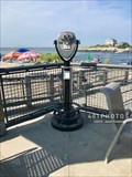 view gallery view galleryE5.5 km |  Coin-Op Binoculars - Looking over Point Judith Harbor - Narragansett, Rhode Island Coin-Op Binoculars - Looking over Point Judith Harbor - Narragansett, Rhode Island
in Coin-Op Binoculars Watch the Block Island Ferry, the commercial fleet of fish and lobster vessels, and sport fishing boats sail in and out of Point Judith Harbor all day long from this vantage on the terrace at Salty Brine State Beach in Narragansett, Rhode Island. posted by: 401Photos location: Rhode Island date approved: 08/15/2019 last visited: never |
 view gallery view galleryE5.5 km |  George's of Galilee Live Web Camera - Narragansett, Rhode Island George's of Galilee Live Web Camera - Narragansett, Rhode Island
in Web Cameras The popular George's of Galilee restaurant offers live web camera view of fishing and ferry vessels entering and exiting the busy Port of Galilee in Narragansett, Rhode Island. posted by: 401Photos location: Rhode Island date approved: 06/27/2022 last visited: never |
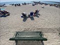
 view gallery view galleryE5.5 km |  Salty Brine State Beach - Narragansett, Rhode Island Salty Brine State Beach - Narragansett, Rhode Island
in Beaches Watch the Block Island Ferry, the commercial fleet of fish and lobster vessels, and sport fishing boats sail in and out of Point Judith Harbor all day from Salty Brine State Beach in Narragansett, Rhode Island. The sand is soft and the waves calm. posted by: 401Photos location: Rhode Island date approved: 08/08/2019 last visited: never |
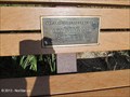
 view gallery view galleryE5.5 km |  Colonel Michael J. Mulligan at Salty Brine State Beach - Narragansett, Rhode Island Colonel Michael J. Mulligan at Salty Brine State Beach - Narragansett, Rhode Island
in Dedicated Benches Colonel Michael J. Mulligan USAR is remembered with a dedicated park bench at Salty Brine State Beach in Galilee, Narragansett, Rhode Island. posted by: 401Photos location: Rhode Island date approved: 09/18/2022 last visited: never |
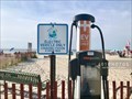 view gallery view galleryE5.5 km |  EV Charging Station at Salty Brine State Beach - Narragansett, Rhode Island EV Charging Station at Salty Brine State Beach - Narragansett, Rhode Island
in Electric Car Charging Stations This ChargePoint CT4021 electric vehicle charging station in Narragansett, Rhode Island, is located at the the most excellent parking spot for Salty Brine State Beach. Your car is front and center at the entrance and practically on the sand! posted by: 401Photos location: Rhode Island date approved: 09/20/2019 last visited: never |
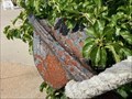 view gallery view galleryE5.5 km |  Anchor at Champlain's Seafood - Narragansett, Rhode Island Anchor at Champlain's Seafood - Narragansett, Rhode Island
in Anchors Come for the anchor, stay for the Champlain's Seafood at Salty Brine State Beach in Narragansett, Rhode Island. posted by: 401Photos location: Rhode Island date approved: 01/20/2023 last visited: never |
 view gallery view gallery W5.6 km W5.6 km
|  Libraries - Cross Mills, Charlestown RI Libraries - Cross Mills, Charlestown RI
in Libraries Quiet library location in this smaller village posted by: The Blue Quasar location: Rhode Island date approved: 11/21/2008 last visited: 10/25/2008 |
 view gallery view galleryE5.6 km |  The Bait Company - Galilee, Narragansett, Rhode Island The Bait Company - Galilee, Narragansett, Rhode Island
in Bait Shops Andrea Incollingo started The Bait Company in 1984. Today, she sells about 1,000,000 skate to Point Judith fishermen each year to bait their lobster traps. posted by: 401Photos location: Rhode Island date approved: 07/31/2021 last visited: never |
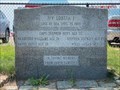 view gallery view galleryE5.6 km |  F/V Lobsta I - Lost At Sea - Point Judith, Rhode Island F/V Lobsta I - Lost At Sea - Point Judith, Rhode Island
in Maritime Monuments and Memorials A granite memorial for the crew of the lobster fishing vessel Lobsta I stands across from the southeast shore of Galilee Salt Pond Harbor along Great Island Road in Narragansett, Rhode Island. It honors the five men lost at sea on September 23, 1978. posted by: 401Photos location: Rhode Island date approved: 07/18/2021 last visited: never |
 view gallery view galleryE5.6 km | Nautical Flag Pole at RI DEM - Narragansett, Rhode Island in Nautical Flag Poles A nautical flag pole stands in the west corner of the Rhode Island Department of Environmental Management, Division of Coastal Resources and Division of Enforcement property on Great Island Road in the Port of Galilee, Narragansett, Rhode Island. posted by: 401Photos location: Rhode Island date approved: 07/19/2021 last visited: never |
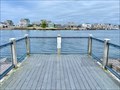
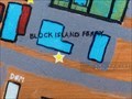 view gallery view galleryE5.6 km | You Are Here - Block Island Ferry Terminal - Galilee, Rhode Island in 'You Are Here' Maps One of a series along Great Island Road, this interpretive sign about the Port of Galilee commercial fishing industry features a map with with a "You Are Here" for the Block Island Ferry terminal. posted by: 401Photos location: Rhode Island date approved: 01/07/2022 last visited: never |
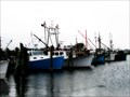 view gallery view galleryE5.6 km |  Port of Galilee - Narragansett, RI Port of Galilee - Narragansett, RI
in Commercial Fishing Ports The port of Galilee - a commercial fishing port in southern Rhode Island. #27 posted by: TerraViators location: Rhode Island date approved: 09/30/2016 last visited: 12/23/2021 |
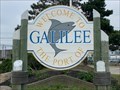 view gallery view galleryE5.8 km | Galilee, Rhode Island in Names From the Bible Galilee, Rhode Island shares its name with an Israeli and Lebanese area. From the Bible, Galilee was the home of Jesus. Both places are known for their commercial fishing industry. posted by: 401Photos location: Rhode Island date approved: 10/16/2021 last visited: never |
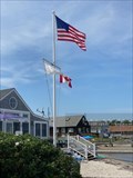
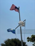
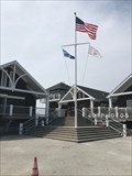 view gallery view galleryE6.4 km | Nautical Flag Pole at Roger Wheeler State Beach - Narragansett, Rhode Island in Nautical Flag Poles A nautical flag pole stands at the entrance to Roger Wheeler State Beach in Narragansett, Rhode Island. The US, RI, and RI-DEM flags were hoisted in a strong breeze on the day of my visit. posted by: 401Photos location: Rhode Island date approved: 08/06/2019 last visited: never |
 view gallery view galleryW6.4 km | Fran and Charles Nash, Ninigret National Wildlife Refuge - Charlestown, RI in Dedicated Benches This bench for Fran and Charles Nash overlooks the brackish water of Ninigret Pond and off the end of an old airport runway once used for training by the U.S. Navy. posted by: NorStar location: Rhode Island date approved: 03/21/2014 last visited: never |
|