 view gallery view gallery E19.3 km E19.3 km
|   Pawnee National Grassland - Grover, CO Pawnee National Grassland - Grover, CO
in Public Access Lands This grassland in northeastern Colorado provides many recreational opportunities such as wildlife and bird watching, hiking, camping and shooting. posted by:  IJAdventures IJAdventures location: Colorado date approved: 06/07/2013 last visited: 11/09/2019 |
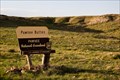
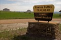 view gallery view galleryE20.9 km |  Pawnee Buttes Trailhead - Grover, CO Pawnee Buttes Trailhead - Grover, CO
in Hiking and walking trailheads A 1.5 mile trail leads to the base of the Pawnee Buttes in Pawnee National Grassland. posted by: IJAdventures location: Colorado date approved: 06/13/2013 last visited: 07/02/2016 |
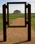 view gallery view galleryE21.1 km |  Pawnee Buttes - Grover, CO Pawnee Buttes - Grover, CO
in Framed Views An old sign frame accents the main feature at the Pawnee Buttes trailhead. posted by: IJAdventures location: Colorado date approved: 06/14/2013 last visited: 07/25/2018 |
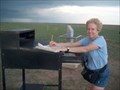
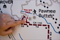 view gallery view galleryE21.1 km |  "You Are Here" at Pawnee Buttes - Grover, CO "You Are Here" at Pawnee Buttes - Grover, CO
in 'You Are Here' Maps You are at the Pawnee Buttes trailhead in the Pawnee National Grassland. posted by: IJAdventures location: Colorado date approved: 06/13/2013 last visited: 05/03/2014 |
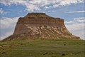 view gallery view galleryE21.4 km |  Pawnee Buttes - Grover, CO Pawnee Buttes - Grover, CO
in American Guide Series Rising 300 feet above the surrounding landscape, these pillars are the most recognizable landmarks in the Pawnee National Grassland. posted by: IJAdventures location: Colorado date approved: 06/13/2013 last visited: 07/02/2016 |
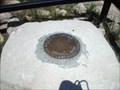 view gallery view gallery NE21.9 km NE21.9 km
|  Tripoint of Wyoming, Nebraska, Colorado (ColoNeWy?) Tripoint of Wyoming, Nebraska, Colorado (ColoNeWy?)
in Tripoints and Multipoints Three states at once: CO, NE and WY posted by: Eagle1977 location: Colorado date approved: 01/02/2013 last visited: 05/06/2021 |
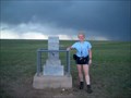 view gallery view galleryNE22.5 km |  HIGHEST -- Point in Nebraska HIGHEST -- Point in Nebraska
in Superlatives Monument at the highest point in Nebraska posted by: Prying Pandora location: Nebraska date approved: 06/10/2007 last visited: 05/06/2021 |
 view gallery view galleryNE22.5 km |  The Highest Point in Nebraska The Highest Point in Nebraska
in Summit Registers The Highest Point in the State of Nebraska posted by: Prying Pandora location: Nebraska date approved: 06/08/2007 last visited: 05/06/2021 |
 view gallery view galleryNE22.5 km |  Nebraska High Point (Panorama Point) Nebraska High Point (Panorama Point)
in Geographic High Points Panorama Point, though not a mountain or hill, is the highest point in the state of Nebraska. posted by:  madmallard madmallard location: Nebraska date approved: 03/22/2011 last visited: 05/06/2021 |
 view gallery view gallery S22.7 km S22.7 km
| Seven Cross Hill - Briggsdale, CO in American Guide Series This hill served as a lookout point for the Seven Cross Ranch and is listed in Tour 2 (State 14) of the Colorado guide. posted by: IJAdventures location: Colorado date approved: 06/11/2013 last visited: 10/15/2016 |
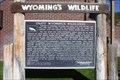 view gallery view gallery N36.2 km N36.2 km
|  Wyoming'a Wildlife-Enjoy Wyoming's Wildlands Wyoming'a Wildlife-Enjoy Wyoming's Wildlands
in Wyoming Historical Markers Located in the rest area near Pine Bluffs along I-80. posted by: Markerman62 location: Wyoming date approved: 10/12/2015 last visited: 08/11/2023 |
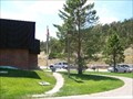 view gallery view galleryN36.2 km |  Pine Bluffs Rest Area - Wyoming Pine Bluffs Rest Area - Wyoming
in Highway Rest Areas This pleasant rest area is close to I-80 at the Wyoming-Nebraska border. posted by:  NevaP NevaP location: Wyoming date approved: 09/24/2007 last visited: 04/21/2017 |
 view gallery view galleryN36.5 km |  A&W - Pine Bluffs, WY A&W - Pine Bluffs, WY
in A + W Restaurants Almost the only place for a visitor to eat at in Pine Bluffs, WY, so this place is often busy. posted by: Spooty location: Wyoming date approved: 08/28/2016 last visited: never |
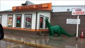 view gallery view galleryN36.5 km |  Sinclair Oil Dinosaur - Pine Bluffs, WY Sinclair Oil Dinosaur - Pine Bluffs, WY
in Dinosaur Statues Dinosaur statue at a roadside gas station in Pine Bluffs, Wyoming. posted by: AnthemRose location: Wyoming date approved: 11/15/2017 last visited: never |
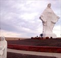 view gallery view galleryN37.7 km |  Virgin Mary - Pine Bluffs, WY, US Virgin Mary - Pine Bluffs, WY, US
in Statues of Religious Figures This statue of the Blessed Virgin Mary, in Pine Bluffs, is one of the largest concrete sculptures and one of the largest Marian shrines in the United States. posted by: hoteltwo location: Wyoming date approved: 08/16/2013 last visited: 02/15/2017 |
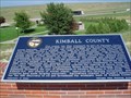 view gallery view galleryNE46.5 km |  Kimball County # 165 Kimball County # 165
in Nebraska Historical Markers Marker about a Nebraska County. posted by: Biker Ozzy location: Nebraska date approved: 03/21/2010 last visited: 06/22/2015 |
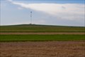
 view gallery view gallery W48 km W48 km
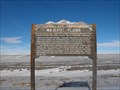
|  Majestic Plains - Carr, Co Majestic Plains - Carr, Co
in Colorado Historical Markers This marker is located about a mile east of Carr, Co in a pull-off on US-85. It describes the surrounding plains and their history. posted by: onfire4jesus location: Colorado date approved: 07/15/2013 last visited: 01/28/2015 |
 view gallery view galleryW48.1 km |  Wyoming / Colorado Border - Highway 29/85, Colorado Wyoming / Colorado Border - Highway 29/85, Colorado
in Border Crossings a border crossing between the US states of Wyoming and Colorado located on highway 25/85 in Colorado, USA. posted by: oiseau_ca location: Wyoming date approved: 09/20/2015 last visited: 01/12/2022 |
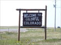
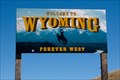 view gallery view galleryW48.4 km |  Wyoming: "Forever West" - US 85 Wyoming: "Forever West" - US 85
in Welcome Signs Welcome to Wyoming, "Forever West" posted by: IJAdventures location: Wyoming date approved: 09/09/2011 last visited: 04/19/2023 |
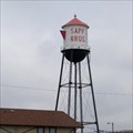 view gallery view gallery NW48.6 km NW48.6 km
|  Sapp Brothers Water Tower- Cheyenne, WY Sapp Brothers Water Tower- Cheyenne, WY
in Water Towers A truck stop water tower shaped like a coffee pot. posted by: NevaP location: Wyoming date approved: 05/26/2007 last visited: 07/21/2017 |
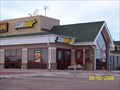
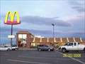 view gallery view galleryNW48.9 km |  McDonalds on E. Lincolnway - Cheyenne, Wy McDonalds on E. Lincolnway - Cheyenne, Wy
in McDonald's Restaurants McDonalds located on E. Lincolnway in Cheyenne Wyoming. posted by: Avi8torAce location: Wyoming date approved: 03/09/2008 last visited: 01/30/2021 |
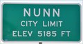 view gallery view galleryW50.1 km |  Nunn, Colorado (Northern Approach) ~ Elevation 5185 Feet Nunn, Colorado (Northern Approach) ~ Elevation 5185 Feet
in Elevation Signs This Elevation Sign is located on the west side of US Highway 85 at the northern town limit of Nunn, Colorado. posted by: brwhiz location: Colorado date approved: 02/10/2013 last visited: 07/21/2017 |
 view gallery view galleryNW50.1 km |  SUBWAY - Campstool Rd. and I-80 SUBWAY - Campstool Rd. and I-80
in Subway Restaurants SUBWAY - Located in Campstool Rd. and I-80 Exit 367. posted by: Avi8torAce location: Wyoming date approved: 02/28/2008 last visited: 01/30/2021 |
 view gallery view gallery SW51.3 km SW51.3 km
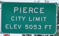
| Pierce, Colorado (Northern Approach) ~ Elevation 5053 Feet in Elevation Signs This Elevation Sign is located on the west side of US Highway 85 at Rowe Avenue on the northern town limit of Pierce, Colorado. posted by: brwhiz location: Colorado date approved: 02/11/2013 last visited: never |
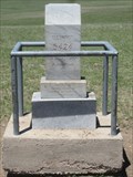
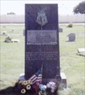 view gallery view gallerySW52.3 km |  Joe P. Martinez-Ault CO Joe P. Martinez-Ault CO
in Medal Of Honor Resting Places World War II Medal of Honor Recipient for action in Attu, Aleutians, Alaska on May 26, 1943. He was killed in action. He is buried in Ault Cemetery, Ault, CO in Block 2, Section 15, Lot 1. posted by: Don.Morfe location: Colorado date approved: 11/22/2017 last visited: 12/19/2021 |
|