 view gallery view gallery S1.3 km S1.3 km
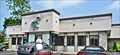
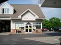
|   Readington Diner - Whitehouse Station, NJ Readington Diner - Whitehouse Station, NJ
in Independent Diners Located at 452 U.S. 22, Whitehouse Station, NJ posted by:  nomadwillie nomadwillie location: New Jersey date approved: 03/30/2013 last visited: never |
 view gallery view gallery N5.1 km N5.1 km
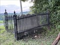
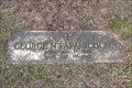
|  Dr. Francis Asbury Farley - Oldwick, NJ Dr. Francis Asbury Farley - Oldwick, NJ
in Out of Place Graves A grave at an intersection in NJ posted by:  chrissyml chrissyml location: New Jersey date approved: 09/01/2021 last visited: never |
 view gallery view gallery W6.8 km W6.8 km
|  Round Valley Beach playgrounds Round Valley Beach playgrounds
in Public Playgrounds Pair of medium-sized metal and plastic playgrounds right on the beach at Round Valley reservoir. posted by: MamaSara location: New Jersey date approved: 09/03/2009 last visited: 12/11/2010 |
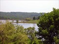 view gallery view galleryW7.1 km |  Deepest -- Man-Made Lake in New Jersey Deepest -- Man-Made Lake in New Jersey
in Superlatives New Jersey's Dept. of Environmental Protection (Division of Parks & Forestry) website boasts Round Valley Recreation Area (state park) has having the largest man-made lake in our great state. posted by: Math Teacher location: New Jersey date approved: 06/17/2009 last visited: 10/19/2014 |
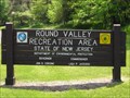
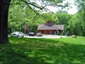
 view gallery view galleryW7.1 km |  Round Valley Recreation Area - Lebanon, NJ Round Valley Recreation Area - Lebanon, NJ
in State/Provincial Parks The Round Valley Reservoir in the U.S. state of New Jersey was formed in 1960 when the New Jersey Water Authority constructed two large dams and flooded a large ravine in the state's Hunterdon County. The lake is the crown jewel of this state park. posted by: Math Teacher location: New Jersey date approved: 06/17/2009 last visited: 10/19/2014 |
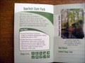
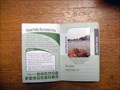 view gallery view galleryW7.1 km |  Round Valley Recreation Area - Your Passport to Adventure - Lebanon, NJ Round Valley Recreation Area - Your Passport to Adventure - Lebanon, NJ
in State Park Passport Locations The Round Valley Reservoir in the U.S. state of New Jersey was formed in 1960 when the New Jersey Water Authority constructed two large dams and flooded a large ravine in the state's Hunterdon County. posted by: Math Teacher location: New Jersey date approved: 06/17/2009 last visited: never |
 view gallery view galleryW7.1 km |  Round Valley Reservoir - Lebanon, NJ Round Valley Reservoir - Lebanon, NJ
in Wikipedia Entries The Round Valley Reservoir in the U.S. state of New Jersey was formed in 1960 when the New Jersey Water Authority constructed two large dams and flooded a large ravine in the state's Hunterdon County. posted by: Math Teacher location: New Jersey date approved: 11/21/2007 last visited: 04/07/2012 |
 view gallery view gallery SE7.2 km SE7.2 km
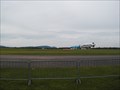
|  Solberg - Hunterdon Airport - Readington, NJ Solberg - Hunterdon Airport - Readington, NJ
in Airports Thor Solberg was the 1st pilot to fly from N. America to Norway in 1935. He started this field in Readington in 1941. It offers great views, seasonal events & an old time family flying atmosphere.
39 Thor Solberg Rd Whitehouse Station, NJ 08889 posted by: mars888 location: New Jersey date approved: 09/03/2013 last visited: 11/26/2013 |
 S8.2 km |  Annual Quick Check New Jersey Festival of Ballooning Annual Quick Check New Jersey Festival of Ballooning
in Hot Air Balloon Festivals Up to 125 Hot Air Balloons Mass ascension twice daily at 6:30 am & 6:30 pm Special shaped balloons are the superstars of the balloon festival. They secure the most popular and sought after balloons in the nation year after year. Whether you are 6 or 60, you will be captivated by the magic of hot air balloons. Balloon activity is wind and weather permitting posted by: chstress53 location: New Jersey date approved: 12/07/2005 last visited: 05/03/2023 |
 view gallery view galleryS8.7 km |  The Glowing Grave of Readington The Glowing Grave of Readington
in Weird Story Locations As seen in Weird NJ, The Glowing Grave of Readington is alive and well. Come see for yourself! posted by: Bugs767 location: New Jersey date approved: 06/10/2013 last visited: 08/19/2013 |
 view gallery view gallery SW9.8 km SW9.8 km
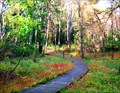
|  Boardwalk Hunterdon County Arboretum - Lebanon, NJ Boardwalk Hunterdon County Arboretum - Lebanon, NJ
in Non-Coastal Boardwalks The display gardens lead to two miles of nature trails that meander from wetlands traversed by a raised boardwalk to groves of ornamental and exotic trees and shrubs and evergreen forests. posted by: scornell1 location: New Jersey date approved: 11/03/2009 last visited: never |
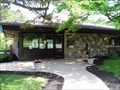
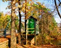
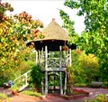 view gallery view gallerySW10 km |  Deats Gazebo - Hunterdon County Arboretum Deats Gazebo - Hunterdon County Arboretum
in Gazebos Rustic gazebo constructed in 1892 was moved to the arboretum in 1979. posted by: scornell1 location: New Jersey date approved: 10/09/2009 last visited: never |
 view gallery view gallery NW10.5 km NW10.5 km
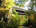
|  Ken Lockwood Gorge Trestle - near Califon, NJ Ken Lockwood Gorge Trestle - near Califon, NJ
in Railroad Bridges A trestle spanning the beautiful and deep Ken Lockwood Gorge. In my opinion one of the prettiest spots in New Jersey. posted by: scornell1 location: New Jersey date approved: 10/09/2009 last visited: 09/04/2010 |
 view gallery view galleryNW10.5 km |  Ken Lockwood Gorge, near Highbridge (Lebanon Twp) NJ Ken Lockwood Gorge, near Highbridge (Lebanon Twp) NJ
in Public Access Lands Considered by many to be one of the top ten beautiful places in the state, Ken Lockwood Gorge is an oasis from the frenetic pace of NJ. posted by: scornell1 location: New Jersey date approved: 10/09/2009 last visited: 09/04/2010 |
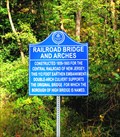 view gallery view galleryW10.5 km |  Railroad Bridge and Arches - High Bridge, NJ Railroad Bridge and Arches - High Bridge, NJ
in New Jersey Historical Markers This unusual double arch bridge supports a railroad in High Bridge NJ. posted by: scornell1 location: New Jersey date approved: 10/09/2009 last visited: 11/24/2011 |
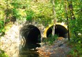 view gallery view galleryW10.6 km | The Arches Railroad Bridge, High Bridge, NJ in Railroad Bridges Double arch supporting railroad bridge in High Bridge NJ posted by: scornell1 location: New Jersey date approved: 10/09/2009 last visited: 07/10/2014 |
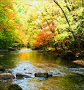
 view gallery view gallerySW10.9 km |  South Branch Raritan River at Stanton NJ South Branch Raritan River at Stanton NJ
in River Gauges USGS 01397000 South Branch Raritan River at Stanton NJ in Hunterdon County NJ. posted by: scornell1 location: New Jersey date approved: 11/03/2009 last visited: never |
 view gallery view gallery E10.9 km E10.9 km
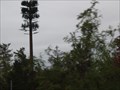
|  The Tall Pine Tree The Tall Pine Tree
in Disguised Cell Towers The Tall Pine Tree cell tower is located in Bedminister NJ posted by: Old Navy location: New Jersey date approved: 10/11/2005 last visited: 04/02/2009 |
 view gallery view gallery NE11.3 km NE11.3 km
|  Dunkin Donuts - Hwy 206 - Bedminster, NJ Dunkin Donuts - Hwy 206 - Bedminster, NJ
in Dunkin Donuts' Dunkin Donuts at a gas station. Located at the corner of US Hwy 206 and Lamington Road. 1525 US Highway 206, Bedminster, NJ 07921
Phone: 908-470-1342 posted by: The Sims location: New Jersey date approved: 06/09/2009 last visited: 06/04/2009 |
 view gallery view galleryW11.3 km |  Dr. George Papanicolaou - Clinton, NJ Dr. George Papanicolaou - Clinton, NJ
in Grave of a Famous Person Grave of Dr. George Papanicolaou, inventor of the Pap test for cervical cancer. posted by: hykesj location: New Jersey date approved: 12/19/2022 last visited: never |
 view gallery view galleryNW11.3 km | Voorhees State Park - New Jersey in State/Provincial Parks Voorhees State Park is a state park in the U.S. state of NJ. It is 632 acres (3 km²) in area, located along the Raritan River in northern Hunterdon County near Glen Gardner. The park is operated and maintained by the NJ Division of Parks & Forestry. posted by: Math Teacher location: New Jersey date approved: 12/03/2007 last visited: 11/24/2011 |
 view gallery view galleryNW11.3 km |  Voorhees State Park - Voorhees State Park -
in American Guide Series Voorhees State Park is a state park in the U.S. state of NJ. It is 632 acres (3 km²) in area, located along the Raritan River in northern Hunterdon County near Glen Gardner. The park is operated and maintained by the NJ Division of Parks & Forestry. posted by: Math Teacher location: New Jersey date approved: 06/17/2009 last visited: 03/15/2010 |
 view gallery view galleryNW11.3 km | Voorhees State Park - Your Passport to Adventure - Glen Gardner, NJ in State Park Passport Locations Voorhees State Park is a state park in the U.S. state of NJ. It is 632 acres (3 km²) in area, located along the Raritan River in northern Hunterdon County near Glen Gardner. The park is operated and maintained by the NJ Division of Parks & Forestry. posted by: Math Teacher location: New Jersey date approved: 06/20/2009 last visited: 11/24/2011 |
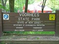 view gallery view galleryNW11.3 km | Voorhees State Park in Wikipedia Entries Voorhees State Park is a state park in the U.S. state of NJ. It is 632 acres (3 km²) in area, located along the Raritan River in northern Hunterdon County near Glen Gardner. The park is operated and maintained by the NJ Division of Parks & Forestry. posted by: Math Teacher location: New Jersey date approved: 11/30/2007 last visited: 11/24/2011 |
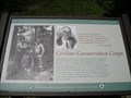 view gallery view galleryNW11.3 km |  Voorhees State Park Voorhees State Park
in Civilian Conservation Corps Voorhees served as a camp for the Civilian Conservation Corps (CCC) - FDR's program to get people back to work during the Depression. The CCC planted trees and constructed shelters, picnic sites and trails throughout the park. posted by: Math Teacher location: New Jersey date approved: 12/08/2007 last visited: 05/05/2012 |
|