 view gallery view gallery E11.3 km E11.3 km
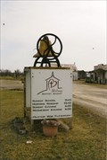
|   Midway Baptist Church Bell - Putnam County, MO Midway Baptist Church Bell - Putnam County, MO
in Bells Sitting on a make-shift box used for a sign, is this brass colored bell. posted by:  YoSam. YoSam. location: Missouri date approved: 04/24/2014 last visited: never |
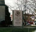
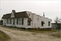 view gallery view galleryE11.3 km |  Midway Baptist Church - Putnam County, MO Midway Baptist Church - Putnam County, MO
in Baptist Churches Baptist Church sitting alone out in the farm country, in a old building that once may have been a highway business (gas station - restaurant) along US 136 posted by: YoSam. location: Missouri date approved: 04/24/2014 last visited: never |
 view gallery view galleryE11.3 km |  Midway Baptist Church - Putnam County, MO Midway Baptist Church - Putnam County, MO
in Country Churches ON US 136, far west of Unionville, old building may have been a business in the 40's on US 136. posted by: YoSam. location: Missouri date approved: 04/24/2014 last visited: never |
 view gallery view gallery NE12.1 km NE12.1 km
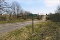
|  St. John - Putnam County, MO St. John - Putnam County, MO
in Ghost Towns Sherman Township to contain Township 66, Range 20, except as above, and that part of Township 67, Range 20, lying in Putnam County, first meeting to be at St. John. posted by: YoSam. location: Missouri date approved: 10/14/2013 last visited: never |
 view gallery view galleryNE12.2 km |  St. John Cemetery (west) - Putnam County, MO St. John Cemetery (west) - Putnam County, MO
in Worldwide Cemeteries This is the cemetery of a ghost town. The original county seat of Dodge County, MO. A county eliminated by the IA-MO Border Wars - known to history as the Honey Wars. posted by: YoSam. location: Missouri date approved: 10/17/2013 last visited: never |
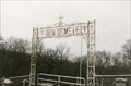
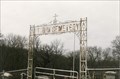 view gallery view galleryNE12.2 km |  St. John Cemetery - Putnam County, MO St. John Cemetery - Putnam County, MO
in Freestanding Arches The cemetery is now called St. John Cemetery (West) because a church which is named "St. John" was built in Grant in the 1950's and their cemetery is called (East). posted by: YoSam. location: Missouri date approved: 11/03/2013 last visited: never |
 view gallery view gallery W21.7 km W21.7 km
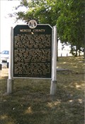
|  Mercer County Mercer County
in Missouri Historical Markers Located in old Calamity Jane Roadside Park on US-65 posted by: YoSam. location: Missouri date approved: 10/17/2013 last visited: 06/07/2018 |
 view gallery view galleryW21.7 km |  FIRST - Settler in County - Mercer County, MO FIRST - Settler in County - Mercer County, MO
in First of its Kind This marker is in a roadside park, that use to be along side all US Highways...not many left today....This one is Calamity Jane Roadside Park. posted by: YoSam. location: Missouri date approved: 10/11/2019 last visited: never |
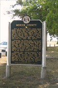 view gallery view galleryW21.7 km |  Mercer County Mercer County
in Human Migration Monuments Located in old Calamity Jane Roadside Park on US-65 posted by: YoSam. location: Missouri date approved: 01/24/2020 last visited: never |
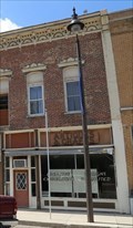
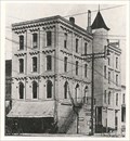
 view gallery view galleryE24.3 km |  112 South Seventeenth Street - Unionville Square Historic District - Unionville, MO 112 South Seventeenth Street - Unionville Square Historic District - Unionville, MO
in NRHP Historic Districts - Contributing Buildings Building #35 on the map.... posted by: YoSam. location: Missouri date approved: 11/19/2019 last visited: never |
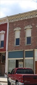 view gallery view galleryE24.3 km |  Unionville Granite Works - Unionville, MO Unionville Granite Works - Unionville, MO
in Victorian Style Architecture Building #35 on the map.... posted by: YoSam. location: Missouri date approved: 11/16/2019 last visited: never |
 view gallery view galleryE24.3 km | Designs Unlimited/Creative Expressions - Unionville, MO in Victorian Style Architecture Building #39 on the map.... posted by: YoSam. location: Missouri date approved: 11/16/2019 last visited: never |
 view gallery view galleryE24.3 km | 110 South Seventeenth Street - Unionville Square Historic District - Unionville, MO in NRHP Historic Districts - Contributing Buildings Building #39 on the map.... posted by: YoSam. location: Missouri date approved: 11/20/2019 last visited: never |
 view gallery view galleryE24.3 km | Russ' Tavern - Unionville, MO in Victorian Style Architecture Building #34 on the map.... posted by: YoSam. location: Missouri date approved: 11/16/2019 last visited: never |
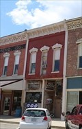 view gallery view galleryE24.3 km | 114 South Seventeenth Street - Unionville Square Historic District - Unionville, MO in NRHP Historic Districts - Contributing Buildings Building #34 on the map.... posted by: YoSam. location: Missouri date approved: 11/19/2019 last visited: never |
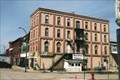 view gallery view galleryE24.3 km | Monroe Drug Company Building - Unionville, MO in Victorian Style Architecture Monroe Drug Company building 1898 - 1905; today called the Subway Building, subway recently closed. posted by: YoSam. location: Missouri date approved: 11/16/2019 last visited: never |
 view gallery view galleryE24.3 km | Monroe Drug Company Building - Unionville Square Historic District - MO in NRHP Historic Districts - Contributing Buildings Monroe Drug Company building 1898 - 1905; today called the Subway Building, subway recently closed. posted by: YoSam. location: Missouri date approved: 04/24/2014 last visited: never |
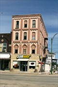
 view gallery view galleryE24.3 km |  Subway - 1700 Main St. - Unionville, MO Subway - 1700 Main St. - Unionville, MO
in Subway Restaurants This Subway is in the historic old Monroe Drug Company Building posted by: YoSam. location: Missouri date approved: 04/25/2014 last visited: never |
 view gallery view galleryE24.3 km |  Monroe Drug Company - Unionville, MO Monroe Drug Company - Unionville, MO
in Photos Then and Now "The Putnam dye industry, now of Quincy, Illinois, was founded in Unionville by E.N. Monroe, J. H. Elson and others as "Monroe Drug Company, 1890 posted by: YoSam. location: Missouri date approved: 04/24/2014 last visited: never |
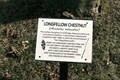 view gallery view galleryE24.5 km | Longfellow chestnut ~ Unionville, MO in Missouri Historical Markers A series of trees located on the courthouse lawn, with history attached. posted by: YoSam. location: Missouri date approved: 01/01/2014 last visited: never |
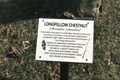 view gallery view galleryE24.5 km |  Wadsworth Longfellow - Unionville, MO Wadsworth Longfellow - Unionville, MO
in Dead Poets' Society Memorials A series of trees located on the courthouse lawn, with history attached. posted by: YoSam. location: Missouri date approved: 11/19/2019 last visited: never |
 view gallery view galleryE24.5 km |  Wadsworth Longfellow - Tree Memorial - Unionville, MO Wadsworth Longfellow - Tree Memorial - Unionville, MO
in Etched in Stone One of a series of historic trees around the courthouse. posted by: YoSam. location: Missouri date approved: 11/17/2019 last visited: never |
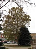 view gallery view galleryE24.5 km |  Putman County Moon Tree - Unionville, Missouri Putman County Moon Tree - Unionville, Missouri
in Moon Trees Moon tree on the grounds of the Putman County Courthouse in Unionville, Missouri. posted by:  BruceS BruceS location: Missouri date approved: 02/06/2010 last visited: 02/07/2010 |
 view gallery view galleryE24.5 km |  History Branches Out - Unionville, MO History Branches Out - Unionville, MO
in Oddball Museums Historic Trees, A living Heritage Museum posted by: YoSam. location: Missouri date approved: 04/24/2014 last visited: never |
 view gallery view galleryE24.5 km |  History Branches Out - Unionville, MO History Branches Out - Unionville, MO
in History Museums Historic Trees, A living Heritage Museum posted by: YoSam. location: Missouri date approved: 02/21/2023 last visited: never |
|