 view gallery view gallery S0.3 km S0.3 km
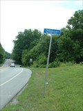
|   Robert Graham House – Newark, Delaware Robert Graham House – Newark, Delaware
in Wikipedia Entries Historic house near Newark Delaware. posted by:  BruceS BruceS location: Delaware date approved: 03/14/2015 last visited: never |
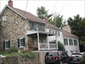 view gallery view galleryS0.3 km |  Graham, Robert, House – Newark, Delaware Graham, Robert, House – Newark, Delaware
in U.S. National Register of Historic Places Historic house near Newark Delaware. posted by: BruceS location: Delaware date approved: 03/16/2015 last visited: never |
 view gallery view gallery W1.6 km W1.6 km
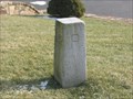
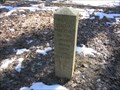
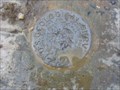
|  USCGS 12-Mile Circle Mile 3, 1893, Delaware-Pennsylvania USCGS 12-Mile Circle Mile 3, 1893, Delaware-Pennsylvania
in U.S. Historic Survey Stones and Monuments USCGS 12-Mile Circle Mile 3, 1982, DE-PA, is a dressed gneiss stone that marks the DE-PA state boundary line along Delaware’s circular northern boundary with Pennsylvania. posted by:  seventhings seventhings location: Delaware date approved: 11/05/2006 last visited: 11/05/2006 |
 view gallery view gallery E2.3 km E2.3 km
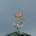
|  Kitten Weather Vane Kitten Weather Vane
in Unique Weathervanes A kitty chasing some mice! posted by:  ODragon ODragon location: Delaware date approved: 09/07/2007 last visited: 03/11/2012 |
 view gallery view gallery NE2.3 km NE2.3 km
|  Daniel Nichols House-Mill Creek Hundred - Hockessin DE Daniel Nichols House-Mill Creek Hundred - Hockessin DE
in Battlefields British General Sir William Howe and his army passed through Mill Creek Hundred. The army ransacked farms taking livestock and supplies. The house served as Howe’s headquarters. posted by: Don.Morfe location: Delaware date approved: 09/19/2020 last visited: 10/17/2021 |
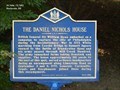 view gallery view galleryNE2.3 km |  The Daniel Nichols House (NC-228) - Hockessin, DE The Daniel Nichols House (NC-228) - Hockessin, DE
in Delaware Historical Markers British General Sir William Howe embarked on a campaign to capture the city of Philadelphia during the Revolutionary War in 1777. The marker is located on Limestone Drive at Sheringham Drive, Hockessin DE, 19707. posted by: Don.Morfe location: Delaware date approved: 09/24/2019 last visited: 10/23/2021 |
 view gallery view gallery SE2.6 km SE2.6 km
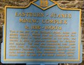
| Eastburn-Jeanes Mining Complex (NC-83) - Newark, DE in Delaware Historical Markers EASTBURN-JEANES MINING COMPLEX posted by: ODragon location: Delaware date approved: 04/03/2009 last visited: never |
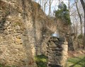 view gallery view gallerySE2.6 km |  Eastburn-Jeanes Mining Complex - Newark, De Eastburn-Jeanes Mining Complex - Newark, De
in Ovens and Kilns EASTBURN-JEANES MINING COMPLEX posted by: ODragon location: Delaware date approved: 04/03/2009 last visited: never |
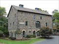
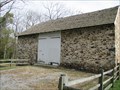 view gallery view galleryS2.6 km | Eastburn, J., Barn – Newark, Delaware in U.S. National Register of Historic Places A historic barn near Newark Delaware. posted by: BruceS location: Delaware date approved: 03/16/2015 last visited: never |
 view gallery view galleryS2.6 km | J. Eastburn Barn – Newark, Delaware in Wikipedia Entries A historic barn near Newark Delaware. posted by: BruceS location: Delaware date approved: 03/16/2015 last visited: never |
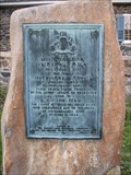
 view gallery view gallerySE3.1 km | Ebenezer United Methodist Church (NC-104) - Newark, DE in Delaware Historical Markers The first meetings of this congregation were held in the homes of its members. In 1824 a stone church building was erected at this location.
The marker is in the church parking lot and located at 525 Polly Drummond Hill Road, Newark, DE 19711. posted by: Don.Morfe location: Delaware date approved: 09/14/2019 last visited: 10/23/2021 |
 view gallery view gallery N3.1 km N3.1 km
|  Delaware / Pennsylvania Crossing at DE 7 / Limestone RD Delaware / Pennsylvania Crossing at DE 7 / Limestone RD
in Border Crossings Border crossing & Northern terminus of DE Route 7 - just S of the intersection of Limestone RD & Southwood RD. posted by: Ernmark location: Pennsylvania date approved: 07/11/2011 last visited: 08/28/2011 |
 view gallery view galleryE3.9 km | J. Lindsay Barn – Newark, Delaware in Wikipedia Entries Historic barn near Newark Delaware. posted by: BruceS location: Delaware date approved: 03/14/2015 last visited: never |
 view gallery view galleryE3.9 km | Lindsay, J., Barn – Newark, Delaware in U.S. National Register of Historic Places Historic barn near Newark Delaware. posted by: BruceS location: Delaware date approved: 03/16/2015 last visited: never |
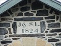 view gallery view galleryE3.9 km |  1824 - J. Lindsay Barn - Newark, Delaware 1824 - J. Lindsay Barn - Newark, Delaware
in Dated Buildings and Cornerstones Historic barn near Newark Delaware. posted by: BruceS location: Delaware date approved: 03/15/2015 last visited: never |
 view gallery view galleryW3.9 km |  Minguannan Indian Town - Landenberg, PA Minguannan Indian Town - Landenberg, PA
in Pennsylvania Historical Markers Minguannan Indian Town... posted by: ODragon location: Pennsylvania date approved: 04/26/2009 last visited: never |
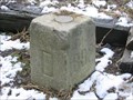
 view gallery view galleryS4 km | Post Mark'd West, 1952, Delaware in U.S. Historic Survey Stones and Monuments Post Mark’d West, 1952, DE, is a granite shaft located in White Clay Creek State Park, DE. It commemorates the initial point that Mason and Dixon used for their survey of the PA-MD boundary line. posted by: seventhings location: Delaware date approved: 08/26/2006 last visited: 10/22/2011 |
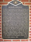 view gallery view galleryNE4 km | Hockessin School #107C (NC-137) - Hockessin, DE in Delaware Historical Markers Hockessin School #107-C posted by: prm location: Delaware date approved: 04/12/2006 last visited: never |
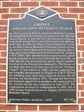 view gallery view galleryNE4.2 km | CHIPPEY (NC-140) - Hockessin, DE in Delaware Historical Markers Chippey, African Union Methodist Church, DE marker NC-140 posted by: prm location: Delaware date approved: 04/13/2006 last visited: never |
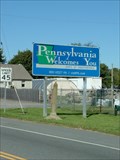
 view gallery view galleryN4.2 km |  Pennsylvania Welcomes You - Kaolin, PA Pennsylvania Welcomes You - Kaolin, PA
in Welcome Signs A Pennsylvania welcome sign located in highway 41. posted by: bluesnote location: Pennsylvania date approved: 09/27/2019 last visited: 09/27/2019 |
 view gallery view galleryN4.2 km | Delaware/Pennsylvania Border at DE/PA 41 in Border Crossings Delaware/Pennsylvania State Border Crossing NW of Wilmington. posted by: Ernmark location: Delaware date approved: 10/18/2008 last visited: 09/01/2019 |
 view gallery view galleryN4.3 km |  USGS “PENNSYLVANIA”, Delaware-Pennsylvania USGS “PENNSYLVANIA”, Delaware-Pennsylvania
in U.S. Benchmarks USGS “PENNSYLVANIA” is a bench mark disk mounted in the top of a dressed gneiss stone, set in 1892, that marks the DE-PA state boundary line along Delaware’s circular northern boundary with Pennsylvania. posted by: seventhings location: Delaware date approved: 09/25/2007 last visited: never |
 view gallery view galleryN4.3 km | USCGS 12-Mile Circle Mile 6, 1893, Delaware-Pennsylvania in U.S. Historic Survey Stones and Monuments USCGS 12-Mile Circle Mile 6, 1982, DE-PA, is a dressed gneiss stone that marks the DE-PA state boundary line along Delaware’s circular northern boundary with Pennsylvania. posted by: seventhings location: Delaware date approved: 09/25/2007 last visited: never |
 view gallery view galleryNE4.3 km |  Dunkin' Donuts - Lancaster Pike - Hockessin, DE Dunkin' Donuts - Lancaster Pike - Hockessin, DE
in Dunkin Donuts' A Dunkin' Donuts in Hockessin, Delaware. posted by: bluesnote location: Delaware date approved: 10/09/2019 last visited: 10/09/2019 |
 view gallery view galleryNE4.3 km |  Prima's Pizza & Pasta - Hockessin, DE Prima's Pizza & Pasta - Hockessin, DE
in Independent Pizza Restaurants A pizza restaurant in Hockessin, Delaware. posted by: bluesnote location: Delaware date approved: 09/07/2019 last visited: 09/07/2019 |
|