 view gallery view gallery E6.8 km E6.8 km
|   Jason Tanner - Sloughhouse , Sacramento Co, CA Jason Tanner - Sloughhouse , Sacramento Co, CA
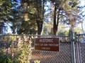
in Eagle Scout Project Sites More than 20 Eagle Scout projects have been completed at this pioneer cemetery over as many years. They have rebuilt monuments, added a paved trail and handrail on a hillside, built a resting place, and posted by:  sbcamper sbcamper location: California date approved: 11/22/2017 last visited: never |
 view gallery view gallery N9.5 km N9.5 km
|  Union Pacific rail yard - Roseville CA Union Pacific rail yard - Roseville CA
in Active Rail Locations A raised concrete platform (about 8 x 10 ft)that raises the viewers above the protective fencing. Great for children. posted by: sbcamper location: California date approved: 02/04/2015 last visited: never |
 view gallery view gallery S12.9 km S12.9 km
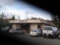
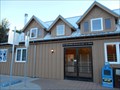
|  Oregon House, CA 95962 Oregon House, CA 95962
in U.S. Post Offices 8753 MARYSVILLE RD OREGON HOUSE CA 95962-9998 posted by:  two bison two bison location: California date approved: 11/18/2006 last visited: never |
 view gallery view gallery NE15.4 km NE15.4 km
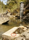
|  Lost Creek Reservoir Dam Lost Creek Reservoir Dam
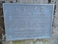
in U.S. Benchmarks Bench mark located approx. 100yds downstream from Lost Creek Reservoir dam. posted by: Dad2Dev location: California date approved: 05/16/2009 last visited: never |
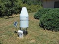 view gallery view galleryE16.4 km |  Yuba River Ranger District - automated - CA Yuba River Ranger District - automated - CA
in Weather Stations R2D2? Solar and self reporting. posted by: sbcamper location: California date approved: 08/07/2016 last visited: never |
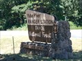 view gallery view galleryE16.4 km |  Yuba River Ranger Station/USFS at Nevada County CA Yuba River Ranger Station/USFS at Nevada County CA
in Ranger Stations Business hours, M - F.
One of four ranger stations on the Tahoe National Forest. posted by: sbcamper location: California date approved: 07/27/2016 last visited: never |
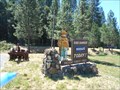 view gallery view galleryE17.1 km |  Yuba Ranger Station Smokey - Camptonville CA Yuba Ranger Station Smokey - Camptonville CA
in Smokey Bear Sign Sightings Has a fire danger indicator/ moderate, high,low. posted by: sbcamper location: California date approved: 08/06/2016 last visited: never |
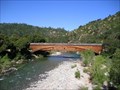
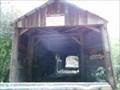 view gallery view gallery SE17.9 km SE17.9 km
|  Oregon Creek Covered Bridge - HW 49 CA Oregon Creek Covered Bridge - HW 49 CA
in Covered Bridges On the Middle Fork of the Yuba River, this bridge was relocated by a broken dam in 1883. It was rotated 180 degrees and came to rest here. posted by: sbcamper location: California date approved: 07/12/2016 last visited: never |
 view gallery view gallerySE17.9 km |  North San Juan Protestant Cemetery - North San Juan CA North San Juan Protestant Cemetery - North San Juan CA
in Worldwide Cemeteries Yes, the Catholics have a separate cemetery at the other end of town. Both are relative small, sidehills. posted by: sbcamper location: California date approved: 07/07/2016 last visited: never |
 view gallery view gallerySE18 km |  George Murphy - North San Juan CA George Murphy - North San Juan CA
in Firefighter Memorials George Murphy was the first fire chief in 1862. posted by: sbcamper location: California date approved: 07/12/2016 last visited: never |
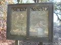
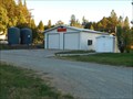 view gallery view gallerySE18 km |  North San Juan Fire Protection District /Station 1 North San Juan Fire Protection District /Station 1
in Firehouses Next to a community hall. posted by: sbcamper location: California date approved: 07/29/2016 last visited: never |
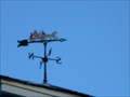 view gallery view gallerySE18 km |  weathervane - North San Juan CA weathervane - North San Juan CA
in Unique Weathervanes Possibly a hand made weathervane for the fire volunteers. It shows a horse drawn fire wagon. posted by: sbcamper location: California date approved: 07/12/2016 last visited: never |
 view gallery view gallerySE18 km | U S P O North San Juan CA in U.S. Post Offices 10 years new? Lots of P O boxes. posted by: sbcamper location: California date approved: 07/07/2016 last visited: never |
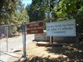 view gallery view gallerySE18 km | St John's Catholic Cemetery - North San Juan CA in Worldwide Cemeteries Noted one gravestone as early as 1824. This is east of town.
One of 19 historic /natural cemeteries in Nevada County (one district).
The church deeded the property to the Nevada cemetery district. posted by: sbcamper location: California date approved: 07/07/2016 last visited: never |
 view gallery view gallery W18.2 km W18.2 km
|  Grey Fox Winery - Oroville CA Grey Fox Winery - Oroville CA
in Wineries Newer winery in Butte County (1996) posted by:  jimmonty jimmonty location: California date approved: 05/31/2008 last visited: 05/26/2008 |
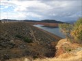
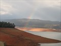 view gallery view galleryW18.7 km |  Lake Oroville SRA - California Lake Oroville SRA - California
in State/Provincial Parks Lake Oroville State Recreation Area is located on the Feather River in the chaparral-oak-pine belt of northern mother-lode country. Lake Oroville, about 75 miles north of Sacramento, is the largest state reservoir in northern California. posted by: DougK location: California date approved: 04/04/2015 last visited: never |
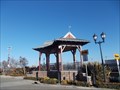
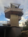 view gallery view galleryW18.7 km |  Visitor Center Tower - Oroville, California Visitor Center Tower - Oroville, California
in Look-Out Towers This Observation tower is located at the Lake Oroville Visitor Center. posted by: DougK location: California date approved: 04/04/2015 last visited: never |
 view gallery view galleryW20.1 km |  Oroville Dam & Edward Hyatt Power Plant - Feather River, California Oroville Dam & Edward Hyatt Power Plant - Feather River, California
in Engineering Landmarks The Oroville Dam and Powerplant received the ACSE Outstanding Projects and Leaders (OPAL) award a year after it was completed in 1969. posted by: DougK location: California date approved: 10/07/2014 last visited: never |
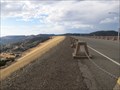
 view gallery view galleryW20.1 km |  Oroville Dam - Oroville, California Oroville Dam - Oroville, California
in Water Dams Oroville Dam is an earthfill embankment dam on the Feather River east of the city of Oroville, California. At 770 feet (230 m) high, it is the tallest dam in the U.S. and serves mainly for water supply, hydroelectricity generation and flood control. posted by: DougK location: California date approved: 10/07/2014 last visited: 02/14/2017 |
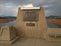
 view gallery view galleryW20.1 km |  TALLEST Dam in USA - Oroville, California TALLEST Dam in USA - Oroville, California
in Superlatives At 770 feet (230 m) high, the Oroville Dam on the Feather River is the tallest dam in the U.S. posted by: DougK location: California date approved: 10/06/2014 last visited: never |
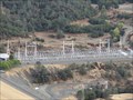 view gallery view galleryW20.1 km |  Edward Hyatt Pump-Generating Plant - Oroville, California Edward Hyatt Pump-Generating Plant - Oroville, California
in Hydroelectric Power Stations In 1968, the Oroville Dam began to generate electricity after completion of the Edward Hyatt Pump-Generating Plant. At that time, it was the country's largest underground power station. posted by: DougK location: California date approved: 10/05/2014 last visited: never |
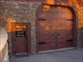
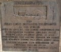 view gallery view gallerySE20.4 km |  First Long Distance Telephone in the World - French Corral, CA First Long Distance Telephone in the World - French Corral, CA
in Signs of History History plaque in community of French Corral. posted by: Volcanoguy location: California date approved: 07/17/2017 last visited: 10/10/2016 |
 view gallery view gallerySE20.4 km |  FIRST - Long Distance Telephone in the World FIRST - Long Distance Telephone in the World
in First of its Kind The first long distance telephone system in the world. posted by: Volcanoguy location: California date approved: 07/25/2017 last visited: 10/10/2016 |
 view gallery view galleryS20.8 km | Bridgeport Covered Bridge in Covered Bridges Longest Single Span Wood Arch Bridge, Built in 1862 posted by: hlalger location: California date approved: 07/06/2006 last visited: 10/10/2016 |
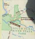 view gallery view galleryS20.9 km |  South Yuba River S.P. - California South Yuba River S.P. - California
in 'You Are Here' Maps ‘You Are Here’ map at South Yuba River S.P. posted by: Volcanoguy location: California date approved: 07/26/2017 last visited: 10/10/2016 |
|