 view gallery view gallery E2.4 km E2.4 km
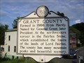
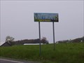
|   Grant County / State of Maryland Grant County / State of Maryland
in West Virginia Historical Markers Two sided sign.
Grant County - Tells who the county was named after.
State of Maryland - Tells who the state was named after. posted by:  Paintedwarrior Paintedwarrior location: West Virginia date approved: 07/07/2012 last visited: 07/14/2012 |
 view gallery view gallery W3.5 km W3.5 km
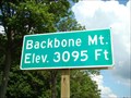
|  Backbone Mountain - Garrett County, MD Backbone Mountain - Garrett County, MD
in Elevation Signs Elevation sign located on State Route 50 in Garrett County, MD posted by:  uccacher uccacher location: Maryland date approved: 09/21/2011 last visited: 08/15/2012 |
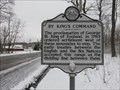 view gallery view galleryE7.2 km | By King's Command in West Virginia Historical Markers A sign telling us to stop settlements west of these mountains. posted by: Paintedwarrior location: West Virginia date approved: 03/21/2016 last visited: 03/20/2016 |
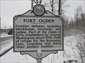 view gallery view galleryE7.2 km | Fort Ogden in West Virginia Historical Markers A sign telling us some of the buildings established by George Washington. posted by: Paintedwarrior location: West Virginia date approved: 03/21/2016 last visited: 03/20/2016 |
 view gallery view gallery NW8 km NW8 km
|  DJ2600(G 198 RESET) - Garrett County MD DJ2600(G 198 RESET) - Garrett County MD
in U.S. Benchmarks This is a Maryland State Highway Administration survey disk in Garrett County. posted by: shorbird location: Maryland date approved: 09/28/2016 last visited: never |
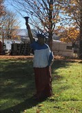 view gallery view galleryNW8.2 km |  Statue of Liberty - Oakland, Maryland Statue of Liberty - Oakland, Maryland
in Statues of Liberty Located in the front yard of a house along the northbound side of Route 219. posted by: flyingmoose location: Maryland date approved: 10/26/2020 last visited: never |
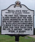 view gallery view galleryNW8.7 km |  "McCulloch's Path" "McCulloch's Path"
in Maryland Historical Markers Located along northbound route 219. Though the trail owes it's origin to buffaloes, they currently no longer roam here. posted by: flyingmoose location: Maryland date approved: 09/17/2006 last visited: 09/16/2012 |
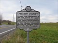 view gallery view galleryW10 km | Preston County, WV / Maryland in West Virginia Historical Markers A two sided sign at the border of Preston County WV and Maryland. posted by: Paintedwarrior location: West Virginia date approved: 10/26/2015 last visited: 10/27/2015 |
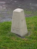 view gallery view galleryW10 km |  Deakins Line Stone #6 (On east side of Rt 219) Deakins Line Stone #6 (On east side of Rt 219)
in U.S. Historic Survey Stones and Monuments A short 1910 re-survey marker to determine the western border of Maryland with West Virginia. posted by: Algoma! location: Maryland date approved: 04/30/2008 last visited: 08/14/2011 |
 view gallery view galleryW10 km |  Maryland / West Virginia on Route 219 Maryland / West Virginia on Route 219
in Border Crossings A border crossing on Rt. 219 with a 1910 border survey monument (#6) at the side of the road. posted by: Algoma! location: Maryland date approved: 05/07/2008 last visited: 08/14/2011 |
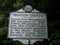 view gallery view galleryW10 km | Maryland / Preston County in West Virginia Historical Markers A two sided sign at the border of Preston County WV and Maryland. posted by: Paintedwarrior location: West Virginia date approved: 08/08/2012 last visited: 08/11/2012 |
 view gallery view gallery N11.1 km N11.1 km
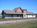
|  Mountain Lake Park Depot - Mountain Lake Park, Maryland Mountain Lake Park Depot - Mountain Lake Park, Maryland
in Train Stations/Depots This depot was designed by E. Francis Baldwin, a prominent Maryland architect who designed hundreds of train stations, churches, and other structures during his career, including the nearby Oakland Station. posted by: Bluejacket01 location: Maryland date approved: 11/30/2011 last visited: 08/29/2012 |
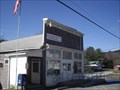
 view gallery view galleryN11.3 km |  Mountain Lake Park, Maryland - 21550 Mountain Lake Park, Maryland - 21550
in U.S. Post Offices The Mountain Lake Park Post Office is located at 1325 Maryland Highway in the Town of Mountain Lake Park, Garrett County, Maryland. It should be noted that this is one of two Post Offices sharing the 21550 Zip Code. The other is Oakland, 2 Miles away posted by: outdoorboy34 location: Maryland date approved: 05/11/2014 last visited: never |
 view gallery view galleryN11.4 km |  Mountain Lake Park Railroad Crossing Bus/Train Collision - Mountain Lake Park, MD Mountain Lake Park Railroad Crossing Bus/Train Collision - Mountain Lake Park, MD
in Disaster Memorials A memorial remembering seven children who died as a result of a school bus / train accident is located on G Street in Mountain Lake Park, Garrett County, Maryland posted by: outdoorboy34 location: Maryland date approved: 05/12/2014 last visited: never |
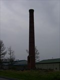 view gallery view galleryN11.4 km |  Oakland, Maryland Solo Chimney #2 Oakland, Maryland Solo Chimney #2
in Lonely Chimneys A tall brick industrial chimney without a factory, next door to a highway department depot. posted by: Algoma! location: Maryland date approved: 04/29/2008 last visited: 09/17/2012 |
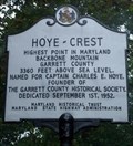
 view gallery view gallery SW11.6 km SW11.6 km
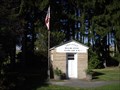
| Hoye - Crest in Maryland Historical Markers Located at the highest point in Maryland. To visit the marker it is about a 1 mile hike from Route 219 in West Virginia. Yes, West Virginia! posted by: flyingmoose location: Maryland date approved: 09/17/2006 last visited: 09/04/2017 |
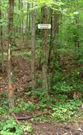 view gallery view gallerySW11.6 km |  The Highest Point In Maryland The Highest Point In Maryland
in Geographic High Points Quick easy 1 mile hike from West Virginia to the top and then you will be there. posted by: flyingmoose location: Maryland date approved: 03/24/2008 last visited: 09/04/2017 |
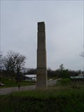
 view gallery view gallerySW11.6 km | 3360 Feet - Oakland, Maryland in Elevation Signs Located at Maryland's high point. posted by: flyingmoose location: Maryland date approved: 10/01/2020 last visited: 05/28/2023 |
 view gallery view gallerySW11.6 km |  Hoye Crest Summit - Garrett County, Maryland Hoye Crest Summit - Garrett County, Maryland
in Mountain Summits Hoye Crest is the highest point in Maryland and is a summit along Backbone Mountain. posted by: r.e.s.t.seekers location: Maryland date approved: 03/27/2022 last visited: never |
 view gallery view galleryN11.6 km | Oakland, Maryland Solo Chimney #1 in Lonely Chimneys An industrial chimney is the only standing item left of a factory. posted by: Algoma! location: Maryland date approved: 04/29/2008 last visited: 09/17/2012 |
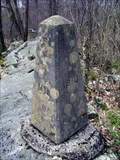 view gallery view gallerySW11.6 km | Deakins Line Stone #3 (near Mt. Backbone summit) in U.S. Historic Survey Stones and Monuments A nice bonus waymark near the highpoint of Maryland. Altitude of the stone is 3348 feet, about 10 feet below the summit level, which is almost in sight. posted by: Algoma! location: Maryland date approved: 04/30/2008 last visited: 09/04/2017 |
 view gallery view galleryE11.7 km | Mount Storm, West Virginia - 26739 in U.S. Post Offices Mount Storm Post Office is located along US Route 50, George Washington Hwy. in Mount Storm, West Virginia. posted by: deano1943 location: West Virginia date approved: 07/09/2010 last visited: 05/28/2012 |
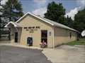
 view gallery view galleryN11.7 km |  Southern Garrett County Rescue Squad - Mountain Lake Park, Maryland Southern Garrett County Rescue Squad - Mountain Lake Park, Maryland
in Paramedic Stations The Southern Garrett County Rescue Squad is located at 200 Baltimore Street in the Town of Mountain Lake Park, Garrett County, Maryland posted by: outdoorboy34 location: Maryland date approved: 05/17/2014 last visited: never |
 view gallery view gallerySW11.7 km | Silver Lake P.O., Silver Lake WV 26716 in U.S. Post Offices Silver Lake P.O., Silver Lake, WV 26716 posted by: dukemartin location: West Virginia date approved: 12/12/2011 last visited: 09/04/2017 |
 view gallery view galleryW12.6 km | Eglon P.O., Eglon WV 26716 in U.S. Post Offices Eglon WV Post office. posted by: dukemartin location: West Virginia date approved: 12/12/2011 last visited: never |
|