 view gallery view gallery NW2.3 km NW2.3 km
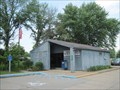
|   Palestine WV Post Office - 26160 Palestine WV Post Office - 26160
in U.S. Post Offices This post office is located at 2841 Palestine Rd in Palestine, WV, which is in Wirt County. posted by:  VQ9JC VQ9JC location: West Virginia date approved: 08/24/2013 last visited: never |
 view gallery view gallery E2.7 km E2.7 km
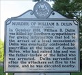
|  Murder of William B. Dulin Murder of William B. Dulin
in West Virginia Historical Markers William B. Dulin killed by southern sympathizers. posted by: dukemartin location: West Virginia date approved: 06/27/2020 last visited: never |
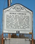 view gallery view galleryE4 km | Ruble Church in West Virginia Historical Markers Ruble Church Wirt County, WV posted by:  two-bit Joe two-bit Joe location: West Virginia date approved: 02/12/2007 last visited: 06/24/2020 |
 view gallery view gallery N5 km N5 km
| Glenville State Teachers College- Glenville, WV in West Virginia Historical Markers A central West Virginia college maintained for the training of grade and high school teachers. posted by: Don.Morfe location: West Virginia date approved: 03/07/2020 last visited: 10/24/2021 |
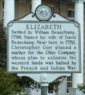 view gallery view galleryN5 km | Elizabeth in West Virginia Historical Markers Settled by William Beauchamp posted by: two-bit Joe location: West Virginia date approved: 11/13/2006 last visited: 06/24/2020 |
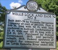 view gallery view galleryN5.5 km | Wells Lock and Dam NO. 3 in West Virginia Historical Markers A lock and dam allowing navigation of Little Kanawha River. posted by: dukemartin location: West Virginia date approved: 06/26/2020 last visited: never |
 view gallery view gallery SE6.4 km SE6.4 km
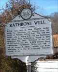
| Rathbone Well in West Virginia Historical Markers Rathbone Well Wirt County, WV posted by: two-bit Joe location: West Virginia date approved: 02/12/2007 last visited: 08/31/2023 |
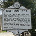 view gallery view gallerySE6.4 km |  FIRST-Well in West Virginia drilled solely for petroleum - Rathbone Well - Burning Springs WV FIRST-Well in West Virginia drilled solely for petroleum - Rathbone Well - Burning Springs WV
in First of its Kind The marker is on WV Route 5, Burning Springs, WV. In 1863, General Jones commanding Confederate forces set fire to the oil stored in tanks, barrels and boats, destroying in a day an estimated 300,000 barrels of oil. posted by: Don.Morfe location: West Virginia date approved: 09/01/2023 last visited: 09/01/2023 |
 view gallery view gallerySE6.4 km |  Rathbone Well - Burning Springs WV Rathbone Well - Burning Springs WV
in Battlefields The marker is on WV Route 5, Burning Springs, WV. In 1863, General Jones commanding Confederate forces set fire to the oil stored in tanks, barrels and boats, destroying in a day an estimated 300,000 barrels of oil. posted by: Don.Morfe location: West Virginia date approved: 09/01/2023 last visited: 09/01/2023 |
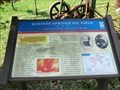 view gallery view gallerySE6.4 km | Burning Springs Oil Field - Burning Springs WV in Battlefields On May 9, 1863, Confederate Gen. William E. “Grumble” Jones led his cavalrymen here to Burning Springs (Oiltown) before continuing southeast. His men set the oil fields afire, and the burning oil turned the Little Kanawha River into a sheet of flames posted by: Don.Morfe location: West Virginia date approved: 11/21/2020 last visited: 10/16/2021 |
 view gallery view gallerySE6.4 km |  Burning Springs Oil Field -"...drank all the whiskey and burned all the oil" - Burning Springs WV Burning Springs Oil Field -"...drank all the whiskey and burned all the oil" - Burning Springs WV
in U.S. Civil War Sites On May 9, 1863, Confederate Gen. William E. “Grumble” Jones led his cavalrymen here to Burning Springs (Oiltown) before continuing southeast. His men set the oil fields afire, and the burning oil turned the Little Kanawha River into a sheet of flames posted by: Don.Morfe location: West Virginia date approved: 07/05/2023 last visited: 07/05/2023 |
 view gallery view gallerySE6.4 km | Burning Springs Oil Field - Burning Springs WV in Civil War Discovery Trail Sites On May 9, 1863, Confederate Gen. William E. “Grumble” Jones led his cavalrymen here to Burning Springs (Oiltown) before continuing southeast. posted by: Don.Morfe location: West Virginia date approved: 08/14/2020 last visited: 10/05/2021 |
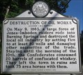 view gallery view gallerySE6.4 km | Destruction of Oil Works in West Virginia Historical Markers Confederates destroyed Oil wells and took horses with them. posted by: dukemartin location: West Virginia date approved: 06/27/2020 last visited: never |
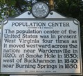 view gallery view gallerySE7.2 km | Population Center in West Virginia Historical Markers One of four locations that the population center of the United States occurred within West Virginia. posted by: dukemartin location: West Virginia date approved: 06/27/2020 last visited: never |
 view gallery view gallery NE14.5 km NE14.5 km
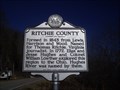
| Ritchie County / Wirt County in West Virginia Historical Markers A two sided sign telling about the formation of the two counties. posted by: Paintedwarrior location: West Virginia date approved: 02/11/2013 last visited: 02/18/2013 |
 view gallery view galleryN17.9 km | Walker WV 26180 in U.S. Post Offices Walker WV 26180 Post Office posted by: dukemartin location: West Virginia date approved: 02/11/2013 last visited: never |
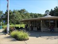
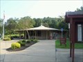 view gallery view galleryNW18.8 km |  Mineral Wells Rest Area NB - I-77 Northbound - Mineral Wells, WV Mineral Wells Rest Area NB - I-77 Northbound - Mineral Wells, WV
in Highway Rest Areas This rest Area is one of a pair located on Interstate 77 near Mile 166 in Mineral Wells, West Virginia. This one in particular is located in the northbound direction of travel. posted by: outdoorboy34 location: West Virginia date approved: 01/26/2017 last visited: 01/29/2021 |
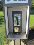 view gallery view galleryNW19 km |  Payphone I-77 South Bound - Mineral Wells, WV Payphone I-77 South Bound - Mineral Wells, WV
in Payphones Payphone in a rest area posted by: uccacher location: West Virginia date approved: 08/22/2011 last visited: never |
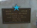 view gallery view galleryNW19 km |  I-77 Southbound - Big Tygart, WV I-77 Southbound - Big Tygart, WV
in Blue Star Memorial Highway Markers This Blue Star Memorial Highway Marker is located at a rest area on I-77 Southbound. posted by: Hawaiian Ninja location: West Virginia date approved: 12/03/2010 last visited: 08/12/2011 |
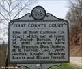 view gallery view galleryE19 km | FIRST - Calhoun County Court - Big Bend WV in First of its Kind First County Court-Site of first Calhoun County Court which met at home of Joseph Burson, April 14, 1856. posted by: Don.Morfe location: West Virginia date approved: 03/09/2023 last visited: 03/09/2023 |
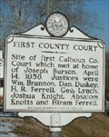 view gallery view galleryE19 km | First County Court in West Virginia Historical Markers Calhoun County, WV. First County Court posted by: two-bit Joe location: West Virginia date approved: 02/12/2007 last visited: 06/24/2020 |
 view gallery view galleryNW21.7 km | I-77 Mile Marker 166 - Mineral Sprints, WV in Highway Rest Areas Rest area accessible when heading southbound on I-77 posted by: uccacher location: West Virginia date approved: 08/24/2011 last visited: 01/29/2021 |
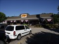 view gallery view galleryNW22.9 km |  Cracker Barrel Restaurant #126, Mineral Wells, West Virginia Cracker Barrel Restaurant #126, Mineral Wells, West Virginia
in Cracker Barrel Restaurants This Cracker Barrel Restaurant is located at I-77 Exit 170 and SR. 14, in Mineral Wells, West Virginia. posted by: deano1943 location: West Virginia date approved: 07/08/2010 last visited: 11/13/2011 |
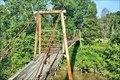 view gallery view galleryE23.3 km |  Parker Suspension Bridge - Smithville WV Parker Suspension Bridge - Smithville WV
in Pedestrian Suspension Bridges 39.075484, -81.124464 posted by: nomadwillie location: West Virginia date approved: 12/31/2022 last visited: never |
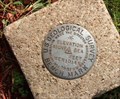 view gallery view gallery S24.3 km S24.3 km
|  MERIDIAN MERIDIAN
in U.S. Benchmarks Located on the Market Street side of the Roane County Court House lawn, Spencer, WV.
In very good condition
posted by: two-bit Joe location: West Virginia date approved: 10/31/2006 last visited: 04/30/2008 |
|