 view gallery view gallery S0.3 km S0.3 km
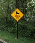
|   Goose Crossing - Potomac, Maryland Goose Crossing - Potomac, Maryland
in Uncommon Crossing Signs Goose crossing sign located along Clara Barton Parkway. posted by:  flyingmoose flyingmoose location: Maryland date approved: 05/17/2021 last visited: never |
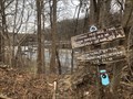
 view gallery view gallery SE0.5 km SE0.5 km
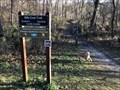
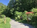
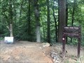
|  Bill Goat Trail (Section C East End) - Potomac, Maryland Bill Goat Trail (Section C East End) - Potomac, Maryland
in Hiking and walking trailheads Eastern End of the Billy Goat Trail Section C posted by: flyingmoose location: Maryland date approved: 07/19/2021 last visited: never |
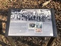
 view gallery view gallery SW0.8 km SW0.8 km
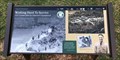
|  NP 2 MD - Potomac, Maryland NP 2 MD - Potomac, Maryland
in Civilian Conservation Corps CCC Camp that was located at the southern end of Bear Island. posted by: flyingmoose location: Maryland date approved: 07/19/2021 last visited: never |
 view gallery view gallery E1 km E1 km
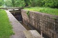
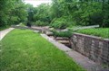
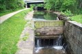
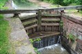
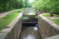
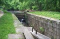
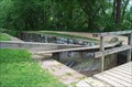
|  C&O Canal - Lock #14 C&O Canal - Lock #14
in Waterway Locks, Planes and Lifts Lock #14 (of 74) on the Chesapeake & Ohio Canal - Seven Locks #7 - Mile 9.47 posted by:  ParrotRob ParrotRob location: Maryland date approved: 05/17/2006 last visited: 07/04/2013 |
 view gallery view galleryE1.1 km | C&O Canal - Lock #13 in Waterway Locks, Planes and Lifts Lock #13 (of 74) on the Chesapeake & Ohio Canal - Seven Locks #6 - Mile 9.37 posted by: ParrotRob location: Maryland date approved: 05/17/2006 last visited: 07/04/2013 |
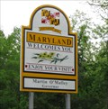
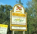 view gallery view galleryE1.1 km |  Welcome to Maryland - Glen Echo, MD Welcome to Maryland - Glen Echo, MD
in Welcome Signs A Maryland welcome sign on I-495 (Capital Beltway) as you cross over the Potomac River from McLean, Virginia. posted by: bluesnote location: Maryland date approved: 02/22/2021 last visited: 02/22/2021 |
 view gallery view galleryE1.1 km |  MD/VA on I-495 MD/VA on I-495
in Border Crossings The VA/MD crossing on I-495. This border crossing goes over the Potomac Border. posted by: saopaulo1 location: Maryland date approved: 05/14/2009 last visited: 10/06/2018 |
 view gallery view galleryE1.3 km | C&O Canal - Lock #12 in Waterway Locks, Planes and Lifts Lock #12 (of 74) on the Chesapeake & Ohio Canal - Seven Locks #5 - Mile 9.29 posted by: ParrotRob location: Maryland date approved: 05/17/2006 last visited: 07/04/2013 |
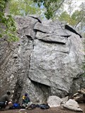 view gallery view gallery W1.3 km W1.3 km
|  Carderock - Potomac, Maryland Carderock - Potomac, Maryland
in Established Rock Climbing Areas Located within the Carderock Recreation Area of the C&O Canal National Historical Park. posted by: flyingmoose location: Maryland date approved: 06/16/2021 last visited: never |
 view gallery view gallerySE1.3 km | Potomac Heritage Trail - McLean, Virginia in Hiking and walking trailheads Located at the end of Live Oak Road. posted by: flyingmoose location: Virginia date approved: 07/05/2022 last visited: never |
 view gallery view gallerySW1.3 km |  Burling Defenders - McLean, Virginia Burling Defenders - McLean, Virginia
in Signs of History Located along the river trail at Scotts Run Nature Preserve. posted by: flyingmoose location: Virginia date approved: 10/06/2022 last visited: never |
 view gallery view galleryW1.3 km | Bill Goat Trail (Section C West End) - Potomac, Maryland in Hiking and walking trailheads Western End of the Billy Goat Trail Section C posted by: flyingmoose location: Maryland date approved: 07/19/2021 last visited: never |
 view gallery view galleryE1.8 km | C&O Canal - Lock #11 in Waterway Locks, Planes and Lifts Lock #11 (of 74) on the Chesapeake & Ohio Canal - Seven Locks #4 - Mile 8.97 posted by: ParrotRob location: Maryland date approved: 05/17/2006 last visited: 07/04/2013 |
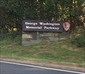
 view gallery view gallerySE1.9 km | ") George Washington Memorial Parkway - McLean, VA George Washington Memorial Parkway - McLean, VA
in National Parks (U.S.) One of the only roads that serve as a national park. The above coordinates are for the western terminus of the GW parkway, at I-495 in McLean, Virginia where the photos were taken. The eastern terminus is Mt. Vernon. posted by: bluesnote location: Virginia date approved: 12/22/2018 last visited: 03/23/2022 |
 view gallery view gallerySE1.9 km |  George Washington Memorial Parkway - McLean, VA George Washington Memorial Parkway - McLean, VA
in Wikipedia Entries One of the only roads that serve as a national park. The above coordinates are for the western terminus of the GW parkway, at I-495 in McLean, Virginia where the photos were taken. The eastern terminus is Mt. Vernon. posted by: bluesnote location: Virginia date approved: 12/22/2018 last visited: 03/23/2022 |
 view gallery view gallerySE1.9 km |  George Washington Memorial Parkway - McLean, VA George Washington Memorial Parkway - McLean, VA
in National Parks of the World One of the only roads that serve as a national park. The above coordinates are for the western terminus of the GW parkway, at I-495 in McLean, Virginia where the photos were taken. The eastern terminus is Mt. Vernon. posted by: bluesnote location: Virginia date approved: 12/21/2018 last visited: 03/23/2022 |
 view gallery view galleryE1.9 km | C&O Canal - Lock #10 in Waterway Locks, Planes and Lifts Lock #10 (of 74) on the Chesapeake and Ohio Canal - Seven Locks #3 - Mile 8.79 posted by: ParrotRob location: Maryland date approved: 05/17/2006 last visited: 07/04/2013 |
 view gallery view galleryE2.1 km | C&O Canal - Lock #9 in Waterway Locks, Planes and Lifts Lock #9 (of 74) on the Chesapeake & Ohio Canal - Seven Locks #2 - Mile 8.70 posted by: ParrotRob location: Maryland date approved: 05/17/2006 last visited: 07/04/2013 |
 view gallery view galleryE2.6 km | C&O Canal - Lock #8 in Waterway Locks, Planes and Lifts Lock #8 (of 74) on the Chesapeake & Ohio Canal - Seven Locks #1 - Mile 8.33 posted by: ParrotRob location: Maryland date approved: 05/17/2006 last visited: 04/13/2014 |
 view gallery view gallery NE3.1 km NE3.1 km
| Cabin John Trail (River Road) - Bethesda, Maryland in Hiking and walking trailheads Parking located on the westbound side of River Road. posted by: flyingmoose location: Maryland date approved: 09/03/2021 last visited: never |
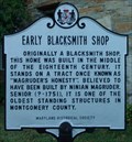 view gallery view galleryNE3.2 km |  Early Blacksmith Shop Early Blacksmith Shop
in Maryland Historical Markers Located at the intersection or River Road and Seven Locks Road. This house is a private home so please do not disturb the inhabitants. posted by: flyingmoose location: Maryland date approved: 08/21/2006 last visited: 07/04/2013 |
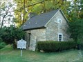 view gallery view galleryNE3.2 km |  Magruder Blacksmith Shop Magruder Blacksmith Shop
in Blacksmith Shops Located at the intersection or River Road and Seven Locks Road. This house is a private home so please do not disturb the inhabitants. posted by: flyingmoose location: Maryland date approved: 06/23/2020 last visited: 07/04/2013 |
 view gallery view galleryE3.5 km | Cabin John Trail (Southern End) - Glen Echo, Maryland in Hiking and walking trailheads Southern terminus trailhead located along Macarthur Boulevard. posted by: flyingmoose location: Maryland date approved: 09/07/2021 last visited: never |
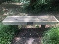 view gallery view galleryE3.7 km |  Linda Marie Billings - Cabin John, Maryland Linda Marie Billings - Cabin John, Maryland
in Dedicated Benches A bench on the side of Macarthur Blvd. posted by: flyingmoose location: Maryland date approved: 08/06/2020 last visited: 05/02/2021 |
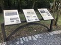 view gallery view galleryE3.7 km | Union Arch Bridge - Cabin John, Maryland in Signs of History Located on the west side of the bridge is a set of signs about the bridge and surrounding area. posted by: flyingmoose location: Maryland date approved: 09/30/2020 last visited: 05/02/2021 |
|