 view gallery view gallery W0.3 km W0.3 km
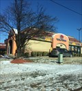
|   Dunkin' Donuts - Wifi Hotspot - Capitol Heights, MD Dunkin' Donuts - Wifi Hotspot - Capitol Heights, MD
in Wi-Fi Hotspots A Dunkin' Donuts in Capitol Heights. posted by:  bluesnote bluesnote location: Maryland date approved: 01/08/2018 last visited: 01/08/2018 |
 view gallery view galleryW0.3 km |  Dunkin Donuts - Central Ave. - Capitol Heights, MD Dunkin Donuts - Central Ave. - Capitol Heights, MD
in Dunkin Donuts' A Dunkin' Donuts in Capitol Heights. posted by: bluesnote location: Maryland date approved: 01/10/2018 last visited: 01/10/2018 |
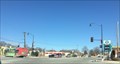
 view gallery view galleryW0.5 km | Taco Bell - Wifi Hotspot - Capitol Heights, MD in Wi-Fi Hotspots A Taco Bell in Capitol Heights. posted by: bluesnote location: Maryland date approved: 01/07/2018 last visited: 01/07/2018 |
 view gallery view galleryW0.5 km |  Taco Bell - Central Ave. - Capitol Heights, MD Taco Bell - Central Ave. - Capitol Heights, MD
in Taco Bell Restaurants A Taco Bell in Capitol Heights. posted by: bluesnote location: Maryland date approved: 01/08/2018 last visited: 01/08/2018 |
 view gallery view galleryW0.5 km |  Subway - Central Ave. - Capitol Heights, MD Subway - Central Ave. - Capitol Heights, MD
in Subway Restaurants A Subway in Capitol Heights. posted by: bluesnote location: Maryland date approved: 01/08/2018 last visited: 01/08/2018 |
 view gallery view galleryW0.5 km |  Domino's - Central Ave. - Capitol Heights, MD Domino's - Central Ave. - Capitol Heights, MD
in Domino's Pizza A Domino's in Capitol Heights. posted by: bluesnote location: Maryland date approved: 01/08/2018 last visited: 01/08/2018 |
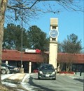 view gallery view galleryW0.6 km |  Addison Plaza Clock - Capitol Heights, MD Addison Plaza Clock - Capitol Heights, MD
in Town Clocks A clock tower in Addison Plaza in Capitol Heights, Maryland. posted by: bluesnote location: Maryland date approved: 01/07/2018 last visited: 01/07/2018 |
 view gallery view galleryW0.6 km |  GameStop - Central Ave. - Capitol Heights, MD GameStop - Central Ave. - Capitol Heights, MD
in Used Video-Game Stores A GameStop in Capitol Heights. posted by: bluesnote location: Maryland date approved: 01/08/2018 last visited: 01/08/2018 |
 view gallery view galleryW1.1 km |  Maryland Park Bicycles - Capitol Heights, MD Maryland Park Bicycles - Capitol Heights, MD
in Bicycle Shops A bike shop in Capitol Heights, Maryland. posted by: bluesnote location: Maryland date approved: 01/09/2018 last visited: 01/09/2018 |
 view gallery view gallery E1.4 km E1.4 km
|  7/11 - Central Ave. - Capitol Heights, MD 7/11 - Central Ave. - Capitol Heights, MD
in 7-Eleven Stores A 7/11 in Capitol Heights. posted by: bluesnote location: Maryland date approved: 01/08/2018 last visited: 01/08/2018 |
 view gallery view gallery NW1.4 km NW1.4 km
|  DC East Cornerstone - Washington, DC DC East Cornerstone - Washington, DC
in Tripoints and Multipoints The eastern boundary stone, marking the eastern edge of the 10 x 10 mile diamond of the District of Columbia. This stone, set in 1791, still stands and continues to mark the official boarder between Washington, DC and Maryland. posted by: bluesnote location: District of Columbia date approved: 01/07/2018 last visited: 01/07/2018 |
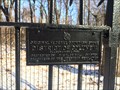 view gallery view galleryNW1.4 km |  DC East Cornerstone - 1791 - Washington, DC DC East Cornerstone - 1791 - Washington, DC
in Dated Architectural Structures Multifarious The eastern boundary stone, marking the eastern edge of the 10 x 10 mile diamond of the District of Columbia. This stone, set in 1791, still stands and continues to mark the official boarder between Washington, DC and Maryland. posted by: bluesnote location: District of Columbia date approved: 01/07/2018 last visited: 01/07/2018 |
 view gallery view galleryNW1.4 km |  DC East Cornerstone - Washington, DC DC East Cornerstone - Washington, DC
in Border Crossings The eastern boundary stone, marking the eastern edge of the 10 x 10 mile diamond of the District of Columbia. This stone, set in 1791, still stands and continues to mark the official boarder between Washington, DC and Maryland. posted by: bluesnote location: District of Columbia date approved: 01/06/2018 last visited: 01/06/2018 |
 view gallery view galleryNW1.4 km |  EASTERNMOST -- Point in DC - Washington, DC EASTERNMOST -- Point in DC - Washington, DC
in Superlatives The eastern boundary stone, marking the eastern edge of the 10 x 10 mile diamond of the District of Columbia. This stone, set in 1791, still stands and continues to mark the official boarder between Washington, DC and Maryland. posted by: bluesnote location: District of Columbia date approved: 01/06/2018 last visited: 01/06/2018 |
 view gallery view galleryNW1.4 km |  DC East Cornerstone - Washington, DC DC East Cornerstone - Washington, DC
in U.S. Benchmarks The eastern boundary stone, marking the eastern edge of the 10 x 10 mile diamond of the District of Columbia. This stone, set in 1791, still stands and continues to mark the official boarder between Washington, DC and Maryland. posted by: bluesnote location: District of Columbia date approved: 01/06/2018 last visited: 01/06/2018 |
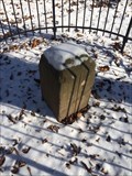 view gallery view galleryNW1.4 km |  DC East Cornerstone - Washington, DC DC East Cornerstone - Washington, DC
in U.S. National Register of Historic Places The eastern boundary stone, marking the eastern edge of the 10 x 10 mile diamond of the District of Columbia. This stone, set in 1791, still stands and continues to mark the official boarder between Washington, DC and Maryland. posted by: bluesnote location: District of Columbia date approved: 01/07/2018 last visited: 01/07/2018 |
 view gallery view galleryNW1.4 km |  DC East Cornerstone - Washington, DC DC East Cornerstone - Washington, DC
in Public Land Survey Marks The eastern boundary stone, marking the eastern edge of the 10 x 10 mile diamond of the District of Columbia. This stone, set in 1791, still stands and continues to mark the official boarder between Washington, DC and Maryland. posted by: bluesnote location: District of Columbia date approved: 01/06/2018 last visited: 01/06/2018 |
 view gallery view galleryNW1.4 km |  DC East Cornerstone - Washington, DC DC East Cornerstone - Washington, DC
in U.S. Historic Survey Stones and Monuments The eastern boundary stone, marking the eastern edge of the 10 x 10 mile diamond of the District of Columbia. This stone, set in 1791, still stands and continues to mark the official boarder between Washington, DC and Maryland. posted by: bluesnote location: District of Columbia date approved: 01/15/2018 last visited: 01/15/2018 |
 view gallery view galleryNW1.4 km |  DC East Cornerstone - Washington, DC, USA DC East Cornerstone - Washington, DC, USA
in Daughters of the American Revolution The eastern boundary stone, marking the eastern edge of the 10 x 10 mile diamond of the District of Columbia. This stone, set in 1791, still stands and continues to mark the official boarder between Washington, DC and Maryland. posted by: bluesnote location: District of Columbia date approved: 05/04/2023 last visited: never |
 view gallery view galleryNW1.6 km | Martin Luther King Jr. Highway - Seat Pleasant, MD / Washington, DC in Border Crossings A border crossing along Martin Luther King Jr. Highway when it changes from jurisdictions from Maryland to the District of Columbia. posted by: bluesnote location: District of Columbia date approved: 01/09/2018 last visited: 01/09/2018 |
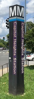 view gallery view galleryW1.6 km |  Capitol Heights Station - Capitol Heights, Maryland Capitol Heights Station - Capitol Heights, Maryland
in The Underground Located at the Eastern Tip of Washington, D.C. at the intersection of East Capitol Street and Southern Avenue. posted by: flyingmoose location: Maryland date approved: 07/01/2021 last visited: never |
 view gallery view galleryW1.6 km | East Capitol St. - Capitol Heights, MD / Washington, DC in Border Crossings A border crossing along Capitol Street when it changes from jurisdictions from Maryland to the District of Columbia. posted by: bluesnote location: District of Columbia date approved: 01/09/2018 last visited: 01/09/2018 |
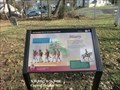 view gallery view galleryNW1.9 km |  Misery Star-Spangled Banner National Historic Trail - Capitol Heights, MD Misery Star-Spangled Banner National Historic Trail - Capitol Heights, MD
in War of 1812 In the stifling heat on August 24, 1814, British soldiers struggled to keep up their march. They rested at Addison Chapel prior to that afternoon’s battle at Bladensburg. posted by:  Don.Morfe Don.Morfe location: Maryland date approved: 03/04/2020 last visited: 11/02/2021 |
 view gallery view galleryNW1.9 km |  Misery Star-Spangled Banner National Historic Trail - Capitol Heights, MD Misery Star-Spangled Banner National Historic Trail - Capitol Heights, MD
in Signs of History In the stifling heat on August 24, 1814, British soldiers struggled to keep up their march. They rested at Addison Chapel prior to that afternoon’s battle at Bladensburg. posted by: Don.Morfe location: Maryland date approved: 08/27/2022 last visited: 08/27/2022 |
 view gallery view galleryE1.9 km | Subway - Central Ave. - Hyattsville, MD in Subway Restaurants A Subway in Hyattsville. posted by: bluesnote location: Maryland date approved: 01/08/2018 last visited: 01/08/2018 |
|