 view gallery view gallery N0 km N0 km
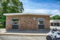
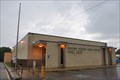
|   Carbondale, KS 66414 Carbondale, KS 66414
in U.S. Post Offices Located at 201-299 Main St, Carbondale, KS posted by:  nomadwillie nomadwillie location: Kansas date approved: 01/01/2020 last visited: never |
 view gallery view gallery SE3.2 km SE3.2 km
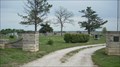
|  Carbondale Cemetery - Carbondale, Ks Carbondale Cemetery - Carbondale, Ks
in Worldwide Cemeteries This large rural cemetery is located at the corners of E 149th & S Adams. It is located SE of the town of Carbondale. posted by: iconions location: Kansas date approved: 05/16/2009 last visited: 09/07/2014 |
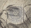
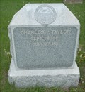 view gallery view gallerySE3.2 km |  Charles V Taylor - Carbondale Cemetery - Carbondale, Ks Charles V Taylor - Carbondale Cemetery - Carbondale, Ks
in Woodmen of the World Grave Markers/Monuments This marble monument with seal is located in the Carbondale cemetery. The cemetery is at the corners of E 149th & S Adams. Some of the outer roads in the cemetery are new and are still very soft.
posted by: iconions location: Kansas date approved: 05/16/2009 last visited: 09/07/2014 |
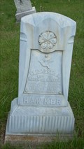 view gallery view gallerySE3.2 km |  Hawker - Carbondale Cemetery - Carbondale, Ks Hawker - Carbondale Cemetery - Carbondale, Ks
in Zinc Headstones This small zinc headstone from 1906 is located in a very large rural cemetery SE of the town of Carbondale Ks. The Cemetery is at the corners of E 149th & S Adams. posted by: iconions location: Kansas date approved: 05/16/2009 last visited: 09/07/2014 |
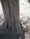 view gallery view gallery NE8 km NE8 km
|  Headstone eating tree - Yocum Cemetery - Shawnee County, Ks Headstone eating tree - Yocum Cemetery - Shawnee County, Ks
in Omnivorous Trees This example of an Omnivorous Tree is located in the Yocum Cemetery in rural Shawnee County Southeast of Topeka on SE101st near the intersection oc S California Road. posted by: iconions location: Kansas date approved: 08/08/2009 last visited: 03/14/2010 |
 view gallery view galleryNE9.3 km |  NGS Benchmark JE1763 - Shawnee County, Ks NGS Benchmark JE1763 - Shawnee County, Ks
in U.S. Benchmarks This disk is located 1/2 mile south of SE101st ST on S Croco Rd. posted by: iconions location: Kansas date approved: 02/26/2009 last visited: never |
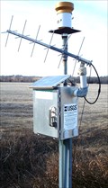
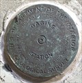 view gallery view galleryNE11.7 km | USGS Benchmark 06891260 - Shawnee County, Ks in U.S. Benchmarks This gauging station mark is located on the Wakarusa River on the NW corner of the SE Paulen Rd Bridge in rural Shawnee County, Ks.
posted by: iconions location: Kansas date approved: 03/01/2009 last visited: never |
 view gallery view galleryNE11.7 km |  Wakarusa River Gauge 06891260 - near Richland, Ks Wakarusa River Gauge 06891260 - near Richland, Ks
in River Gauges This gauge is located on the Wakarusa River on the NW corner of the SE Paulen Rd Bridge. posted by: iconions location: Kansas date approved: 02/23/2009 last visited: never |
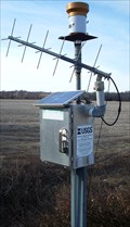
 view gallery view galleryNE11.7 km |  Wakarusa River Solar Powered Gauge - near Richland, Ks Wakarusa River Solar Powered Gauge - near Richland, Ks
in Solar Power This gauge is located on the Wakarusa River on the NW corner of the SE Shadden Rd Bridge.
posted by: iconions location: Kansas date approved: 02/28/2009 last visited: never |
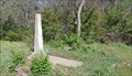
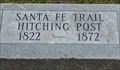 view gallery view gallery E13.4 km E13.4 km
|  Overbrook Santa Fe Trail Hitching Post - Overbrook, Ks Overbrook Santa Fe Trail Hitching Post - Overbrook, Ks
in Wagon Roads and Trails This marker is located in the Overbrook Cemetery. posted by: iconions location: Kansas date approved: 05/16/2009 last visited: 03/01/2023 |
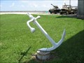 view gallery view galleryN13.7 km |  Combat Air Museum, Topeka, KS ANCHOR? Combat Air Museum, Topeka, KS ANCHOR?
in Anchors Is this Anchor lost? posted by: BackPak location: Kansas date approved: 08/30/2007 last visited: 03/03/2019 |
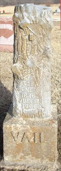 view gallery view galleryNE14.3 km | Isaac Vail - Mount Pleasant Cemetery - Shawnee County, Ks in Woodmen of the World Grave Markers/Monuments This Modern Woodman of America marker is located in the Mount Pleasant Cemetery - SE 85th and SE Ratner in rural Shawnee County. posted by: iconions location: Kansas date approved: 08/08/2009 last visited: never |
 view gallery view galleryE18.7 km | Simmons Point - Santa Fe Trail - near Overbrook, Kansas in Wagon Roads and Trails THis historical marker and DAR marker combination are located on the south side of US-56 one mile east of the Douglas - Osage line. posted by: iconions location: Kansas date approved: 05/16/2009 last visited: never |
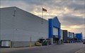 view gallery view galleryN20.1 km |  Wal*Mart Super Center #2131 - Topeka, KS Wal*Mart Super Center #2131 - Topeka, KS
in WAL*MART Stores This Wal*Mart Super Center is just northeast of Interstate 470 in Topkea, Kansas. posted by: The Snowdog location: Kansas date approved: 05/06/2022 last visited: never |
 view gallery view galleryN20.3 km |  Downed Cold War Aircraft Memorial - Topeka, Ks. Downed Cold War Aircraft Memorial - Topeka, Ks.
in Roadside Attractions This memorial is located in front of the entrance to Major Palm Park located at 1815 SW 37th. posted by: iconions location: Kansas date approved: 03/04/2014 last visited: never |
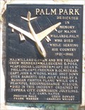
 view gallery view galleryN20.3 km |  Major Willard G Palm - Topeka, Ks Major Willard G Palm - Topeka, Ks
in Specific Veteran Memorials This memorial is located in front of the entrance to Major Palm Park located at 1815 SW 37th. posted by: iconions location: Kansas date approved: 07/22/2009 last visited: never |
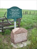
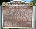 view gallery view galleryN20.3 km |  Capital of Kansas - Shawnee County Capital of Kansas - Shawnee County
in Kansas Historical Markers This marker is in a small roadside park at 37th & Topeka Boulevard. The entrance to the park is on a diagonal road accessed from Topeka Boulevard traveling from the north. posted by: iconions location: Kansas date approved: 07/05/2009 last visited: 11/05/2021 |
 view gallery view galleryN21.9 km | Topeka, Kansas 66605 ~ Hicrest Station in U.S. Post Offices This Post Office is located at 2921 SE Adams Street in Topeka, Kansas. posted by: brwhiz location: Kansas date approved: 09/03/2012 last visited: never |
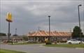
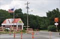 view gallery view galleryN22 km |  McDonalds 29th Street ~ Topeka, Kansas McDonalds 29th Street ~ Topeka, Kansas
in McDonald's Restaurants This McDonalds is located at 3072 SW 29th Street in Topeka, Kansas. posted by: brwhiz location: Kansas date approved: 12/31/2012 last visited: 08/24/2015 |
 view gallery view galleryN22 km |  McDonalds 29th Street Free WiFi ~ Topeka, Kansas McDonalds 29th Street Free WiFi ~ Topeka, Kansas
in Wi-Fi Hotspots Free WiFi Served Daily at the McDonalds located at 3072 SW 29th Street in Topeka, Kansas. posted by: brwhiz location: Kansas date approved: 12/30/2012 last visited: never |
 view gallery view galleryN22.4 km |  Abrams Burnett - Topeka, KS Abrams Burnett - Topeka, KS
in Out of Place Graves The grave of Abrams Burnette, Chief of the Pottawatomies, is at the end of a dike in Topeka, Kansas. posted by: The Snowdog location: Kansas date approved: 04/23/2023 last visited: never |
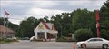
 view gallery view galleryN22.5 km | McDonalds 2933 Wanamaker Road ~ Topeka, Kansas in McDonald's Restaurants This McDonalds is located at 2933 SW Wanamaker Road in Topeka, Kansas. posted by: brwhiz location: Kansas date approved: 12/31/2012 last visited: never |
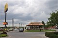 view gallery view galleryN22.5 km | McDonalds 2933 Wanamaker Road Free WiFi ~ Topeka, Kansas in Wi-Fi Hotspots Free WiFi Served Daily at the McDonalds located at 2933 SW Wanamaker Road in Topeka, Kansas. posted by: brwhiz location: Kansas date approved: 12/30/2012 last visited: never |
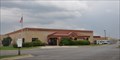 view gallery view galleryN22.9 km | Topeka, Kansas 66614 ~ Sherwood Carrier Annex in U.S. Post Offices This Post Office is located at 6120 SW 29th Street in Topeka, Kansas. posted by: brwhiz location: Kansas date approved: 09/03/2012 last visited: never |
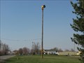 view gallery view galleryNE22.9 km |  Shawnee County Outdoor Warning Device #60 Shawnee County Outdoor Warning Device #60
in Outdoor Warning Sirens Siren used for Tornadoes and National Emergencies. posted by:  kswx29 kswx29 location: Kansas date approved: 07/16/2008 last visited: never |
|