 view gallery view gallery W0.2 km W0.2 km
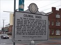
|   Colonial Roads Colonial Roads
in Virginia Historical Markers This Virginia Historical Marker describes the origins of Haymarket at the junction of the Old Carolina Road and a branch of the Dumfries Road. It's located in a small park on Washington Street (Hwy 55) and Fayette Street in Newmarket, Virginia. posted by:  PeterNoG PeterNoG location: Virginia date approved: 02/29/2012 last visited: 02/29/2012 |
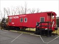 view gallery view galleryW0.2 km |  Southern Caboose X384 - Haymarket VA Southern Caboose X384 - Haymarket VA
in Train Cabooses This Caboose from the Southern Railway is at the Haymarket Museum on the corner of Washington Street and Fayette Street in Haymarket, Virginia. posted by: PeterNoG location: Virginia date approved: 03/06/2012 last visited: 02/29/2012 |
 view gallery view gallery NW1.1 km NW1.1 km
|  Walmart - Trading Square - Haymarket, VA Walmart - Trading Square - Haymarket, VA
in WAL*MART Stores This is the Walmart Supercenter in Haymarket, VA. posted by:  retail96 retail96 location: Virginia date approved: 10/10/2018 last visited: 10/09/2018 |
 view gallery view gallery S2.4 km S2.4 km
|  Bull Run Battlefields - Gainesville VA Bull Run Battlefields - Gainesville VA
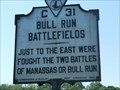
in Battlefields Marker is in Gainesville, Virginia, in Prince William County on Lee Highway (U.S. 29). The marker was erected in 1934 by Conservation & Development Commission. (Marker Number C-31.) posted by: Don.Morfe location: Virginia date approved: 08/03/2023 last visited: 08/03/2023 |
 view gallery view galleryS2.4 km | Bull Run Battlefields in Virginia Historical Markers Just to the east were fought the two battles of Manassas or Bull Run. posted by: Don.Morfe location: Virginia date approved: 03/14/2020 last visited: 10/20/2021 |
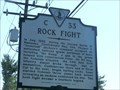 view gallery view galleryS2.4 km | Rock Fight - Gainesville in Battlefields Marker is in Gainesville, Virginia, in Prince William County on Lee Highway (U.S. 29). The marker was erected in 2003 by Department of Historic Resources. (Marker Number C-33.) posted by: Don.Morfe location: Virginia date approved: 08/03/2023 last visited: 08/03/2023 |
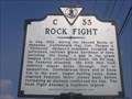 view gallery view galleryS2.4 km | Rock Fight in Virginia Historical Markers This marker describes a rock fight that happened when the Stonewall's men ran out of ammunition, and became a Southern legend. posted by: pixieslayer location: Virginia date approved: 08/04/2006 last visited: 01/27/2024 |
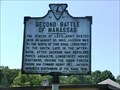 view gallery view galleryS2.4 km |  Second Battle of Manassas - Gainesville, Virginia Second Battle of Manassas - Gainesville, Virginia
in American Civil War Monuments and Memorials The marker is located on Lee Highway (U.S. 29), Gainesville VA 20155 posted by: Don.Morfe location: Virginia date approved: 07/05/2023 last visited: 07/05/2023 |
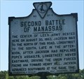 view gallery view galleryS2.4 km | Second Battle of Manassas - Gainesville, Virginia in Battlefields The marker is located on Lee Highway (U.S. 29), Gainesville VA 20155. The marker was erected in 1928 by the Conservation & Development Commission posted by: Don.Morfe location: Virginia date approved: 08/03/2023 last visited: 08/03/2023 |
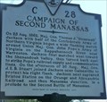 view gallery view galleryS2.4 km | Campaign of Second Manassas - Gainesville in Battlefields Marker is in Gainesville, Virginia, in Prince William County on Lee Highway (U.S. 29). The marker was erected in 2000 by Department of Historic Resources. (Marker Number C-28.) posted by: Don.Morfe location: Virginia date approved: 08/03/2023 last visited: 08/03/2023 |
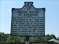 view gallery view galleryS2.4 km | Second Battle of Manassas in Virginia Historical Markers The center of Lee’s army rested here on August 30, 1862; Jackson was to the north of this road, Longstreet to the south. posted by: Don.Morfe location: Virginia date approved: 03/14/2020 last visited: 10/20/2021 |
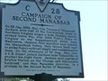 view gallery view galleryS2.4 km | Campaign of Second Manassas in Virginia Historical Markers On 25 Aug. 1862, Maj. Gen. Thomas J. “Stonewall” Jackson with half of the Confederate Army of Northern Virginia began a wide flanking march around Union Maj. Gen. John Pope’s Army of Virginia on the Rappahannock River near Warrenton. posted by: Don.Morfe location: Virginia date approved: 03/14/2020 last visited: 10/20/2021 |
 view gallery view gallery SE3.1 km SE3.1 km
|  KFC - Linton Hall Rd - Gainesville, VA KFC - Linton Hall Rd - Gainesville, VA
in Kentucky Fried Chicken/KFC Restaurants This is the KFC location in Gainesville, VA. posted by: retail96 location: Virginia date approved: 10/08/2018 last visited: never |
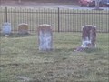 view gallery view gallerySE3.1 km |  Shirley Cemetery - Gainesville, VA Shirley Cemetery - Gainesville, VA
in Out of Place Graves The Shirley Cemetery in Gainesville, Virginia posted by: Rivers End location: Virginia date approved: 02/09/2012 last visited: 02/25/2012 |
 view gallery view gallerySE3.1 km |  Taco Bell - Linton Hall Rd - Gainesville, VA Taco Bell - Linton Hall Rd - Gainesville, VA
in Taco Bell Restaurants This is the Taco Bell location in Gainesville, VA. posted by: retail96 location: Virginia date approved: 10/09/2018 last visited: never |
 view gallery view gallerySE3.2 km |  Burger King - Linton Hall Rd - Gainesville, VA Burger King - Linton Hall Rd - Gainesville, VA
in Burger King Restaurants This is the Burger King location in Gainesville, VA. posted by: retail96 location: Virginia date approved: 10/08/2018 last visited: never |
 view gallery view galleryNW3.2 km |  Camp William B. Snyder - Haymarket, Virginia Camp William B. Snyder - Haymarket, Virginia
in Boy Scout Camps Located along Antioch Road in Haymarket. posted by: flyingmoose location: Virginia date approved: 03/07/2021 last visited: never |
 view gallery view gallerySE3.2 km |  Target - Gateway Center Dr - Gainesville, VA Target - Gateway Center Dr - Gainesville, VA
in Target Stores This is the Super Target location in Gainesville, VA. posted by: retail96 location: Virginia date approved: 10/08/2018 last visited: never |
 view gallery view gallerySE3.2 km |  Petsmart - Gateway Center Dr - Gainesville, VA Petsmart - Gateway Center Dr - Gainesville, VA
in Pet Stores This is the Petsmart location in Gainesville, VA. posted by: retail96 location: Virginia date approved: 10/18/2018 last visited: never |
 view gallery view gallery N3.7 km N3.7 km
|  Domino's - Merchants View Square - Haymarket, VA Domino's - Merchants View Square - Haymarket, VA
in Domino's Pizza This is the Domino's Pizza location in Haymarket, VA. posted by: retail96 location: Virginia date approved: 03/27/2019 last visited: never |
 view gallery view galleryN3.7 km |  Subway - Merchants View Square - Haymarket, VA Subway - Merchants View Square - Haymarket, VA
in Subway Restaurants This is one of the two Subway locations in Haymarket, VA. posted by: retail96 location: Virginia date approved: 10/10/2018 last visited: never |
 view gallery view gallery SW4.8 km SW4.8 km
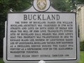
| Buckland in Virginia Historical Markers This marker describes Buckland, a rare American example of the familiar axial English village pattern. The John Love mentioned is responsible for starting the company responsible for the Warrenton-Alexandria Turnpike. There is a small place to park on CR 684, but the tavern itself is private property. posted by: pixieslayer location: Virginia date approved: 07/29/2006 last visited: 12/16/2006 |
 view gallery view galleryN5.3 km | The Carolina Road in Virginia Historical Markers This describes the origins of the Carolina road, which is roughly about where US 15 is at this point. posted by: pixieslayer location: Virginia date approved: 08/03/2006 last visited: 03/03/2010 |
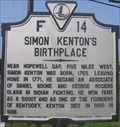 view gallery view galleryN6.4 km | Simon Kenton's Birthplace in Virginia Historical Markers This marker gives a brief description of Simon Kenton, one of the founders of Kentucky. posted by: pixieslayer location: Virginia date approved: 08/04/2006 last visited: 02/26/2012 |
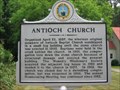 view gallery view galleryNW6.6 km | Antioch Church in Virginia Historical Markers Erected 2002 by Prince William County Historical Commission. posted by: turnersrugs location: Virginia date approved: 02/20/2013 last visited: never |
|