 view gallery view gallery N8.4 km N8.4 km
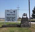
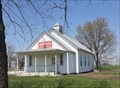
|   New Hope Baptist Church - Wellsville, KS New Hope Baptist Church - Wellsville, KS
in Country Churches New Hope Baptist Church is at the intersection of Highways 68 and 33 in Franklin County, Kansas. posted by:  The Snowdog The Snowdog location: Kansas date approved: 04/05/2021 last visited: never |
 view gallery view galleryN8.4 km |  New Hope Baptist Church - Wellsville, KS New Hope Baptist Church - Wellsville, KS
in Baptist Churches New Hope Baptist Church is at the intersection of Highways 68 and 33 in Franklin County, Kansas. posted by: The Snowdog location: Kansas date approved: 04/05/2021 last visited: never |
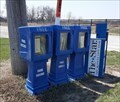 view gallery view galleryN8.4 km |  New Hope Baptist Church Book Exchange - Wellsville, KS New Hope Baptist Church Book Exchange - Wellsville, KS
in Free Community Book Exchanges This well-stocked community book exchange is sponsored by New Hope Baptist Church, in Wellsville, Kansas. posted by: The Snowdog location: Kansas date approved: 04/05/2021 last visited: never |
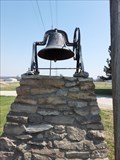 view gallery view galleryN8.4 km |  New Hope Baptist Church Bell - Wellsville, KS New Hope Baptist Church Bell - Wellsville, KS
in Bells This church bell is on display in front of New Hope Baptist Church, south of Wellsville, Kansas. posted by: The Snowdog location: Kansas date approved: 04/05/2021 last visited: never |
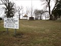
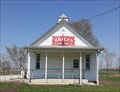 view gallery view galleryN8.9 km |  Briles Schoolhouse - Peoria Township, KS Briles Schoolhouse - Peoria Township, KS
in Former Schools Briles School, built in 1868, served until 1960 and is now the Community Center - in Peoria Township, Kansas. posted by: The Snowdog location: Kansas date approved: 04/06/2021 last visited: 03/15/2015 |
 view gallery view galleryN8.9 km |  Briles Schoolhouse - Peoria Township, KS Briles Schoolhouse - Peoria Township, KS
in Relocated Structures Briles School, built in 1868, served until 1960 and was moved to this location in 1980 - in Peoria Township, Kansas. posted by: The Snowdog location: Kansas date approved: 04/06/2021 last visited: 03/15/2015 |
 view gallery view galleryN8.9 km |  Briles Schoolhouse - Peoria Township, KS Briles Schoolhouse - Peoria Township, KS
in One-Room Schoolhouses Briles School, built in 1868, served until 1960 and is now the Community Center - in Peoria Township, Kansas. posted by: The Snowdog location: Kansas date approved: 04/07/2021 last visited: 03/15/2015 |
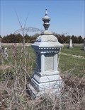 view gallery view gallery NE9.7 km NE9.7 km
|  Sherar - Pleasant Valley Cemetery, Stanton, KS Sherar - Pleasant Valley Cemetery, Stanton, KS
in Zinc Headstones This zinc headstone marks the final resting place of Reverend Robert H. Sherer and three members of his family; in Pleasant Valley Cemetery, west of Paola, Kansas. posted by: The Snowdog location: Kansas date approved: 04/05/2021 last visited: never |
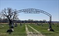 view gallery view galleryNE9.7 km |  Pleasant Valley Cemetery - Stanton, KS Pleasant Valley Cemetery - Stanton, KS
in Worldwide Cemeteries Pleasant Valley Cemetery is on Highway 33, west of Paola, Kansas. posted by: The Snowdog location: Kansas date approved: 04/05/2021 last visited: never |
 view gallery view gallery SE13.5 km SE13.5 km
|  John Brown Cabin - Osawatomie, KS John Brown Cabin - Osawatomie, KS
in U.S. National Register of Historic Places Cabin used as a residence for the abolitionist John Brown. To be clear to the visitor, the cabin is inside of the protective shelter, now built around the cabin. posted by:  gparkes gparkes location: Kansas date approved: 01/22/2010 last visited: never |
 view gallery view gallerySE13.7 km |  Battle of Osawatomie - Osawatomie, KS Battle of Osawatomie - Osawatomie, KS
in U.S. Civil War Sites Arguably, the first lives were lost of the American Civil War at the Battle of Osawatomie. posted by: gparkes location: Kansas date approved: 12/30/2008 last visited: 01/19/2009 |
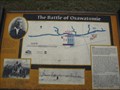 view gallery view gallerySE13.7 km |  Battle of Osawatomie - Osawatomie, KS Battle of Osawatomie - Osawatomie, KS
in Battlefields Battle of Osawatomie - Remember in John Brown State Park posted by: gparkes location: Kansas date approved: 01/03/2009 last visited: 01/29/2009 |
 view gallery view gallerySE13.7 km |  John Brown State Park - Osawatomie, KS John Brown State Park - Osawatomie, KS
in Underground Railroad Sites The John Brown Cabin was a hiding place on the Underground Railroad. posted by: gparkes location: Kansas date approved: 12/30/2008 last visited: 01/29/2009 |
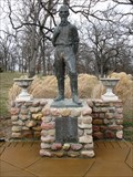 view gallery view gallerySE13.7 km |  John Brown - John Brown State Park - Osawatomie, KS John Brown - John Brown State Park - Osawatomie, KS
in Statues of Historic Figures Statue of John Brown, an abolitionist who fought to keep slavery from entering Kansas. posted by: gparkes location: Kansas date approved: 12/30/2008 last visited: 01/19/2009 |
 view gallery view gallerySE13.7 km |  John Brown State Park Footbridge - Osawatomie, KS John Brown State Park Footbridge - Osawatomie, KS
in Stone Bridges Foot path bridge located in the historic John Brown State Park posted by: gparkes location: Kansas date approved: 12/30/2008 last visited: 01/19/2009 |
 view gallery view gallery E13.7 km E13.7 km
| Creamery Bridge - Osawatomie, Kansas in U.S. National Register of Historic Places The Creamery Bridge goes over the Marais Des Cygnes River at 8th Street just north of Osawatomie, Ks. Parking is available just north and west of the bridge. posted by: iconions location: Kansas date approved: 08/08/2017 last visited: never |
 view gallery view galleryE13.7 km |  Creamery Bridge - Osawatomie, Ks. Creamery Bridge - Osawatomie, Ks.
in Arch Bridges The Creamery Bridge goes over the Marais Des Cygnes River at 8th Street just north of Osawatomie, Ks. Parking is available just north and west of the bridge. posted by: iconions location: Kansas date approved: 08/09/2009 last visited: never |
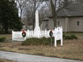 view gallery view gallerySE13.8 km | Soldier's Memorial - Osawatomie, KS in American Civil War Monuments and Memorials Memorial for those who died in the Battle of Osawatomie. posted by: gparkes location: Kansas date approved: 12/30/2008 last visited: 01/19/2009 |
 view gallery view galleryE14.2 km |  Potawatomie Trail of Death Potawatomie Trail of Death
in Wikipedia Entries This rather unassuming marker is anchored to a larger boulder near a Kansas Historical Marker on 6th Street. posted by: iconions location: Kansas date approved: 02/18/2009 last visited: never |
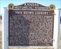 view gallery view galleryE14.2 km |  John Brown Country - Osawatomie, Ks John Brown Country - Osawatomie, Ks
in Kansas Historical Markers This Kansas Historical Marker is located at 6th Street and Lincoln in Osawatomie, Ks. posted by: iconions location: Kansas date approved: 02/16/2009 last visited: 09/03/2011 |
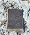 view gallery view galleryE14.2 km |  Potawatomie "Trail of Death" End of Trail Marker - Osawatomie, Ks. Potawatomie "Trail of Death" End of Trail Marker - Osawatomie, Ks.
in Trail of Tears This rather unassuming marker is anchored to a larger boulder near a Kansas Historical Marker. posted by: iconions location: Kansas date approved: 02/16/2009 last visited: 09/03/2011 |
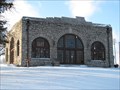
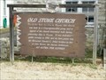 view gallery view galleryE14.2 km | Old Stone Church - Osawatomie, Kansas in Kansas Historical Markers This marker, to the left of the entrance to the old Congregationalist Church built in 1861, is located at 315 Sixth Street in Osawatomie, Kansas. posted by: iconions location: Kansas date approved: 02/25/2020 last visited: never |
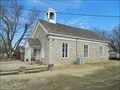 view gallery view galleryE14.2 km |  Old Stone Church - Osawatomie, Kansas Old Stone Church - Osawatomie, Kansas
in Official Local Tourism Attractions The former Osawatomie Congregational Church is located at 315 Sixth Street in Osawatomie, Kansas. posted by: iconions location: Kansas date approved: 02/26/2020 last visited: never |
 view gallery view galleryE14.2 km | Old Stone Church - Osawatomie, Kansas in This Old Church The former Osawatomie Congregational Church is located at 315 Sixth Street in Osawatomie, Kansas. It is now maintained as a historic site and as a chapel. posted by: iconions location: Kansas date approved: 02/25/2020 last visited: never |
 view gallery view galleryE14.2 km |  Downtown Osawatomie Lucky 7 - Osawatomie, Kansas Downtown Osawatomie Lucky 7 - Osawatomie, Kansas
in Lucky 7 This Lucky 7 is centered on the Old Stone Church located at 315 Sixth Street in Osawatomie, Kansas. posted by: iconions location: Kansas date approved: 03/04/2020 last visited: never |
|