 view gallery view gallery W0 km W0 km
|   Canyonlands National Park - Moab UT Canyonlands National Park - Moab UT
in Wikipedia Entries The GPS Coordinates are at the Island in the Sky Visitor Center Canyonlands National Park, Moab UT. posted by:  Don.Morfe Don.Morfe location: Utah date approved: 11/09/2023 last visited: 03/21/2024 |
 view gallery view galleryW0 km |  Canyonlands National Park - Moab UT Canyonlands National Park - Moab UT
in Official Local Tourism Attractions The GPS Coordinates are at the Island in the Sky Visitor Center Canyonlands National Park, Moab UT. posted by: Don.Morfe location: Utah date approved: 11/09/2023 last visited: 03/21/2024 |
 view gallery view galleryW0 km |  Ranger Station at Canyonlands National Park - Moab UT Ranger Station at Canyonlands National Park - Moab UT
in Ranger Stations The GPS Coordinates are at the Island in the Sky Visitor Center Canyonlands National Park, Moab UT. The Ranger Station is inside this Visitor Center. Here one may obtain a NPS Cancellation Stamp. posted by: Don.Morfe location: Utah date approved: 11/22/2023 last visited: 11/22/2023 |
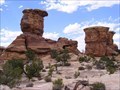
 view gallery view galleryW0 km |  Canyonlands National Park - Moab UT Canyonlands National Park - Moab UT
in Satellite Imagery Oddities The GPS Coordinates are at the Island in the Sky Visitor Center Canyonlands National Park, Moab UT. posted by: Don.Morfe location: Utah date approved: 11/10/2023 last visited: 03/21/2024 |
 view gallery view galleryW0 km |  Dinosaur Diamond Prehistoric Highway - Canyonlands National Park, UT Dinosaur Diamond Prehistoric Highway - Canyonlands National Park, UT
in National Scenic Byways Off of US Highway 191 north of Moab, turn west on Utah highway 313 to reach Canyonlands National Park. The coordinates are for the visitor center. posted by:  RakeInTheCache RakeInTheCache location: Utah date approved: 10/27/2016 last visited: 11/27/2022 |
 view gallery view galleryW0 km |  Canyonlands National Park - Moab, UT Canyonlands National Park - Moab, UT
in National Parks of the World Canyonlands National Park is a U.S. National Park located in southeastern Utah near the town of Moab. The coordinates are of the Island in the Sky Visitor Center. posted by: RakeInTheCache location: Utah date approved: 10/27/2016 last visited: 11/09/2023 |
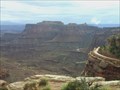
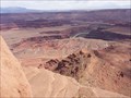
 view gallery view galleryW0 km | ") Canyonlands National Park - Island in the Sky - Moab, UT Canyonlands National Park - Island in the Sky - Moab, UT
in National Parks (U.S.) Island in the Sky is the easiest area of Canyonlands to visit in a short period of time, offering many pullouts with spectacular views along the paved scenic drive. posted by: RakeInTheCache location: Utah date approved: 10/28/2016 last visited: 11/09/2023 |
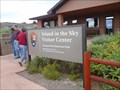
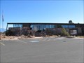
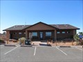 view gallery view galleryW0 km |  Canyonlands NP - Island in the Sky District Visitors Center Canyonlands NP - Island in the Sky District Visitors Center
in Tourist Information Centers - Visitor Centers Visitor Center serving visitors to the Island in the Sky District of Canyonlands National Park in southeastern Utah. posted by: linkys location: Utah date approved: 11/18/2009 last visited: 11/09/2023 |
 view gallery view galleryW0 km |  Canyonlands NP - Island in the Sky District Canyonlands NP - Island in the Sky District
in NPS Passport Cancellation Stations Passport Station in the Island in the Sky Visitors Center of Canyonlands National Park. posted by: linkys location: Utah date approved: 11/18/2009 last visited: 11/09/2023 |
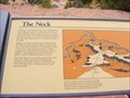 view gallery view gallery S0.8 km S0.8 km
|  The Neck-Canyonlands National Park-Island in the Sky District - Moab UT The Neck-Canyonlands National Park-Island in the Sky District - Moab UT
in Utah Historical Markers The marker is on Grand View Point Road in Grand County, Moab UT 84532. posted by: Don.Morfe location: Utah date approved: 11/10/2023 last visited: 11/10/2023 |
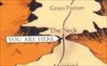 view gallery view galleryS0.8 km |  'You Are Here' Maps-The Neck-Canyonlands National Park - Moab UT 'You Are Here' Maps-The Neck-Canyonlands National Park - Moab UT
in 'You Are Here' Maps 'You Are Here' Map shows that you are on Grand View Point Road in Grand County, Moab UT 84532. posted by: Don.Morfe location: Utah date approved: 11/10/2023 last visited: 11/10/2023 |
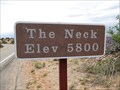 view gallery view galleryS1.1 km |  The Neck - 5800' The Neck - 5800'
in Elevation Signs The sign is located along the Island In The Sky road in Canyonlands National Park. There are separate signs for southbound and northbound traffic. posted by: WR7X location: Utah date approved: 04/28/2012 last visited: 08/27/2015 |
 view gallery view gallery E6.3 km E6.3 km
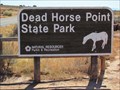
|  Dead Horse Point Moab Utah Dead Horse Point Moab Utah
in Weird Story Locations Dead Horse Point posted by: makeme location: Utah date approved: 06/12/2022 last visited: 06/19/2022 |
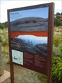
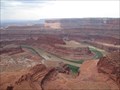 view gallery view galleryE7.1 km |  Dead Horse Point Overlook Dead Horse Point Overlook
in Scenic Roadside Look-Outs Dead Horse Point State Park in Utah hosts many fantastic views of the massive canyon basin carved by the Colorado River. It also plays host to a past tragedy that gives this high mesa its name. These views are breathtaking. posted by:  mtn-man mtn-man location: Utah date approved: 06/03/2006 last visited: 09/07/2019 |
 view gallery view galleryE7.1 km |  The Legend of Dead Horse Point - Moab, Utah The Legend of Dead Horse Point - Moab, Utah
in Urban Legends and Superstitions Legend has it some horses were corralled on this point of land, dying of thirst when water was right in front of them, only it was 2,000 feet down below them in the Colorado River. posted by: linkys location: Utah date approved: 11/18/2009 last visited: 01/07/2016 |
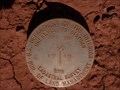 view gallery view galleryE7.6 km |  Potash Road Potash Road
in U.S. Benchmarks This is a BLM Survey Marker on Potash Road just outside Canyonlands, N.P., Utah. posted by: SRL&CAL location: Utah date approved: 10/07/2009 last visited: never |
 view gallery view gallery NE8 km NE8 km
|  Dead Horse Point State Park Guest Book - Utah Dead Horse Point State Park Guest Book - Utah
in Guest Books Guest book in visitor center at Dead Horse State Park near Moab, UT. posted by: linkys location: Utah date approved: 11/19/2009 last visited: 01/07/2016 |
 view gallery view galleryNE8 km | Dead Horse Point State Park Visitor Center - Utah in Tourist Information Centers - Visitor Centers Set on a point, but not the actual Dead Horse Point which is elsewhere in the Park, and overlooking a canyon; it's the perfect setting for a park with this name. posted by: linkys location: Utah date approved: 11/18/2009 last visited: 01/07/2016 |
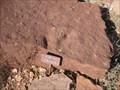 view gallery view galleryNE8 km |  Dino Track - Dead Horse Point State Park Dino Track - Dead Horse Point State Park
in Petrosomatoglyphs Single dinosaur track outside the Dead Horse Point State Park visitors center. posted by: linkys location: Utah date approved: 11/18/2009 last visited: 01/07/2016 |
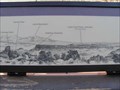 view gallery view galleryNE8 km |  Dead Horse Point Visitor Center Orientation Table - Utah Dead Horse Point Visitor Center Orientation Table - Utah
in Orientation Tables Orientation table on the upper balcony outside viewing area at the Park's visitor center. posted by: linkys location: Utah date approved: 11/18/2009 last visited: 01/07/2016 |
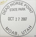 view gallery view galleryNE8 km | Dead Horse Point State Park - Utah in NPS Passport Cancellation Stations Located in the Visitor Center at Dead Horse Point State Park - Utah posted by: DJ&Jules location: Utah date approved: 10/30/2007 last visited: 01/07/2016 |
 view gallery view gallery SW8.9 km SW8.9 km
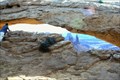
|  Mesa Arch, Island in the sky district, Moab, Utah, USA Mesa Arch, Island in the sky district, Moab, Utah, USA
in Natural Arches A breathtaking view posted by: g300td location: Utah date approved: 09/08/2014 last visited: 03/30/2015 |
 view gallery view gallerySW8.9 km |  Mesa Arch Trail - Canyonlands National Park, UT Mesa Arch Trail - Canyonlands National Park, UT
in Hiking and walking trailheads Mesa Arch is an easy to visit landmark in the Island in the Sky region of Canyonlands National Park. A 0.7-mile loop trail brings you right up to Mesa Arch, one of the park’s most popular points of interest. posted by: RakeInTheCache location: Utah date approved: 11/02/2016 last visited: 03/30/2015 |
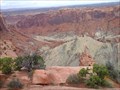 view gallery view galleryW10 km |  Upheaval Dome Trail - Canyonlands National Park, UT Upheaval Dome Trail - Canyonlands National Park, UT
in Scenic Hikes Upheaval Dome in the most puzzling geological feature in Canyonlands National Park. A 1.7-mile hike visits two overlooks along the rim of this three-mile wide 1,000-foot deep crater. posted by: RakeInTheCache location: Utah date approved: 11/02/2016 last visited: 11/09/2023 |
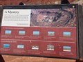 view gallery view galleryW10.1 km |  Upheaval Dome - Canyonlands National Park, Utah Upheaval Dome - Canyonlands National Park, Utah
in Impact Craters Upheaval Dome is located in Canyonlands National Park, Utah. posted by: Géochum location: Utah date approved: 09/08/2016 last visited: 12/18/2022 |
|