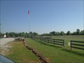
 view gallery view gallery NW1 km NW1 km
|   Tom Sawyer Model Aircraft Association - Louisville, Kentucky Tom Sawyer Model Aircraft Association - Louisville, Kentucky
in Model Aircraft Fields Model aircraft field in a Kentucky state park posted by:  stinger503 stinger503 location: Kentucky date approved: 07/31/2012 last visited: 06/26/2015 |
 NW1.9 km |  Brandon's Barbeque Brandon's Barbeque
in Classic BBQ and Sandwich Joints Nice neighborhood restaurant with smoky barbecue and nice side items. posted by: SherpaRon location: Kentucky date approved: 08/17/2005 last visited: 09/27/2009 |
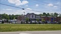 view gallery view gallery N2.1 km N2.1 km
|  ALDI Store - Louisville, Ky ALDI Store - Louisville, Ky
in ALDI Stores Located on Westport Rd. Retail chain selling a range of grocery items, including produce, meat & dairy, at discount prices. posted by:  Lord Mot Lord Mot location: Kentucky date approved: 05/29/2018 last visited: never |
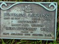 view gallery view gallery SW3.5 km SW3.5 km
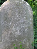
|  Benjamin Lawrence Benjamin Lawrence
in American Revolutionary War Veteran Graves Final Resting place for Benjamin Lawrence. Attained rank of Lieutenant during the American Revolution. Served in the Maryland Militia. Documentation shows he was part of the Soldiers' Delight battalion, Baltimore co. militia, as of 01/06/1776. posted by: ftknoxcache location: Kentucky date approved: 06/01/2010 last visited: 05/25/2018 |
 view gallery view gallerySW3.9 km |  Assumption Greek Orthodox Church - Louisville, KY Assumption Greek Orthodox Church - Louisville, KY
in Orthodox Churches Founded in 1927 by a group of immigrants, the church is called the Assumption in reverence to the Virgin Mary. In 2004, the parish moved to its present location on Ormsby lane and began building a new church and other facilities. posted by: BluegrassCache location: Kentucky date approved: 12/17/2007 last visited: 08/15/2009 |
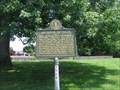
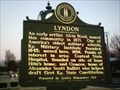 view gallery view gallerySW4.5 km |  Lyndon Lyndon
in Kentucky Historical Markers This marker is located in Lyndon on KY 146. posted by: BluegrassCache location: Kentucky date approved: 12/23/2007 last visited: 01/30/2012 |
 view gallery view gallery S5 km S5 km
| Soldier's Retreat in Kentucky Historical Markers One of two by this name. posted by: ftknoxcache location: Kentucky date approved: 06/07/2010 last visited: 06/03/2010 |
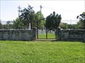
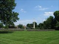 view gallery view galleryS5 km |  Anderson Family Cemetery Anderson Family Cemetery
in Worldwide Cemeteries The family cemetery of Col. Richard Clough Anderson. posted by: ftknoxcache location: Kentucky date approved: 06/04/2010 last visited: 06/03/2010 |
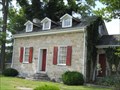 view gallery view gallerySW5 km |  Eight-Mile House - Louisville, KY Eight-Mile House - Louisville, KY
in U.S. National Register of Historic Places Early 19th century stone house with various uses over the years posted by: vhasler location: Kentucky date approved: 06/04/2012 last visited: 07/15/2017 |
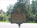 view gallery view gallerySW5 km | Col. William Christian / Fort William in Kentucky Historical Markers Col. William Anderson / Fort William combined marker. posted by: ftknoxcache location: Kentucky date approved: 06/07/2010 last visited: 05/25/2012 |
 view gallery view galleryS5.3 km | Cemetery Surrounded by Development in Worldwide Cemeteries Small family cemetery posted by: ftknoxcache location: Kentucky date approved: 06/04/2010 last visited: 06/03/2010 |
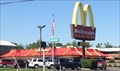 view gallery view galleryS5.8 km |  McDonalds - 1100 Hurstbourne Parkway - Louisville, KY McDonalds - 1100 Hurstbourne Parkway - Louisville, KY
in McDonald's Restaurants Nice McDonalds in east Louisville posted by: stinger503 location: Kentucky date approved: 07/30/2012 last visited: 03/26/2021 |
 view gallery view gallerySW6 km | Bullitt Family Cemetery in Worldwide Cemeteries The Bullitt Family Cemetery contains the final resting places of several historical figures around the Louisville, Jefferson County, KY area. posted by: ftknoxcache location: Kentucky date approved: 06/04/2010 last visited: 06/03/2010 |
 view gallery view gallerySW6.4 km |  Ten Pin Lanes - "… Yet" - Louisville, Kentucky Ten Pin Lanes - "… Yet" - Louisville, Kentucky
in Zippy the Pinhead Locations The citizens of Dingburg came to the Ten Pin Lanes for some bowling and philosophical thought. posted by: DougK location: Kentucky date approved: 05/12/2014 last visited: never |
 view gallery view galleryS6.4 km |  Wendy's - South Hurstbourne Parkway - Louisville, KY Wendy's - South Hurstbourne Parkway - Louisville, KY
in Wendy's Restaurants Wendy's in east Louisville posted by: stinger503 location: Kentucky date approved: 07/26/2012 last visited: never |
 view gallery view gallerySW6.4 km |  Mall St. Matthews - Louisville, KY Mall St. Matthews - Louisville, KY
in Indoor Malls Mall St. Matthews serves the affluent east side of the Louisville metro area. With 1.1 million square feet, Mall St. Matthews is the home of more than 30 retailers not found elsewhere in the market. posted by: BluegrassCache location: Kentucky date approved: 12/16/2007 last visited: 08/15/2009 |
 view gallery view gallerySW6.6 km |  Outback Steakhouse, Louisville, KY Outback Steakhouse, Louisville, KY
in Gluten Free Restaurants Outback Steakhouse across from the St. Matthews Mall in Louisville, KY posted by: Prying Pandora location: Kentucky date approved: 06/05/2012 last visited: never |
 view gallery view gallery NE6.9 km NE6.9 km
|  St. Aloysius Altar Window - Pewee Valley, KY St. Aloysius Altar Window - Pewee Valley, KY
in Stained Glass Windows This window, at the rear of the church, behind the altar is a top to bottom, side-to side window that beckons visitors to look a little closer. Lit up at night you can't miss this massive window wall. posted by: BluegrassCache location: Kentucky date approved: 12/21/2007 last visited: 04/03/2013 |
 view gallery view galleryS6.9 km | Jefferson Town, KY McDs in McDonald's Restaurants Louisville, KY posted by: ChapterhouseInc location: Kentucky date approved: 01/22/2006 last visited: 01/24/2008 |
 view gallery view gallery W6.9 km W6.9 km
| Zachary Taylor National Cemetery, Louisville KY in Worldwide Cemeteries Zachary Taylor National Cemetery is located in Jefferson County, Ky., in northeast Louisville. The cemetery was established in 1928 by an act of Congress initiated by the Taylor family to have the government take title to the family burial site where President Zachary Taylor was interred. posted by: GA Cacher location: Kentucky date approved: 07/12/2007 last visited: 07/21/2018 |
 view gallery view galleryNE7.1 km |  Pewee Valley Presbyterian Church Pewee Valley Presbyterian Church
in Literary Sites This little stone church was the site of the Little Colonel's wedding to Rob Moore in "The Little Colonel's Knight Comes Riding" by Annie Fellows Johnston. posted by: BluegrassCache location: Kentucky date approved: 01/17/2008 last visited: 09/27/2009 |
 view gallery view galleryNE7.1 km |  Pewee Valley Presbyterian Church - Pewee Valley, KY Pewee Valley Presbyterian Church - Pewee Valley, KY
in This Old Church This church, formally organized in 1866, held its first sermon on November 21, 1867. According to the church's website the first member to join the church in 1867 was a Negro woman, Aunt Clary Gordon. posted by: BluegrassCache location: Kentucky date approved: 01/12/2008 last visited: 04/03/2013 |
 view gallery view galleryNE7.1 km |  Little Colonel Playhouse - Pewee Valley, KY Little Colonel Playhouse - Pewee Valley, KY
in Live Stage Theaters In its 51st season the Little Colonel Playhouse is the Louisville area's oldest community theater. Founded and incorporated in 1956 the LCP present four regular season plays a year and a summer youth production. posted by: BluegrassCache location: Kentucky date approved: 01/12/2008 last visited: 09/27/2009 |
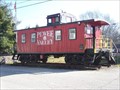 view gallery view galleryNE7.1 km |  Pewee Valley Caboose - Pewee Valley, KY Pewee Valley Caboose - Pewee Valley, KY
in Train Cabooses This caboose is located at the site of railroad station and interurban depot, presented by the Pewee Valley Historical Society. The caboose sits right next to the railroad tracks that run directly in front of the main street, Mt. Mercy Drive. posted by: BluegrassCache location: Kentucky date approved: 01/14/2008 last visited: 04/03/2013 |
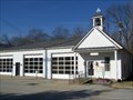 view gallery view galleryNE7.1 km |  Pewee Valley, KY Pewee Valley, KY
in City and Town Halls A stop called Smith's Station was set up about 1 1/2 miles from the Rollington settlement, between Anchorage and LaGrange. This would later become Pewee Valley, named for the Eastern Wood Pewee, although the town is on a ridge, not a valley. posted by: BluegrassCache location: Kentucky date approved: 01/12/2008 last visited: 09/27/2009 |
|