 view gallery view gallery SE25.1 km SE25.1 km
|   N 38 W 100 ~ SW of Jetmore, Kansas N 38 W 100 ~ SW of Jetmore, Kansas
in Confluence Spots This point of intersection for 38 degrees north latitude and 100 degrees west longitude occurs along a rural road north of Dodge City and a few miles southwest of Jetmore, Kansas. posted by:  brwhiz brwhiz location: Kansas date approved: 05/30/2012 last visited: 08/30/2019 |
 view gallery view gallery N29.3 km N29.3 km
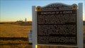
|  Homestead of a genius Homestead of a genius
in Kansas Historical Markers One of the world's most important scientists, George Washington Carver, spent his formative years in Kansas. posted by:  azswade azswade location: Kansas date approved: 12/16/2010 last visited: 10/06/2017 |
 view gallery view gallery S44.6 km S44.6 km
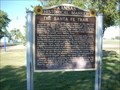
|  Santa Fe Trail - Howell Trail Ruts Santa Fe Trail - Howell Trail Ruts
in Wagon Roads and Trails This is a two mile section of Santa Fe Trail Ruts located 1/2 mile west of Howell, Kansas on US-50. Site has been listed as a Historic Landmark. posted by: iconions location: Kansas date approved: 12/01/2008 last visited: 01/05/2023 |
 view gallery view galleryS44.6 km |  Santa Fe Trail Ruts - near Howell, Kansas Santa Fe Trail Ruts - near Howell, Kansas
in U.S. National Register of Historic Places This is a two mile section of Santa Fe Trail Ruts located 1/2 mile west of Howell, Kansas on US-50. posted by: iconions location: Kansas date approved: 12/02/2008 last visited: 01/05/2023 |
 view gallery view galleryS44.7 km |  Ft Larned, Santa Fe Trail, Howell, KS Ft Larned, Santa Fe Trail, Howell, KS
in 'You Are Here' Maps This "You Are Here" tells you that you are at the Santa Fe Trail. posted by: Queens Blessing location: Kansas date approved: 06/06/2010 last visited: 05/01/2020 |
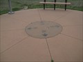 view gallery view galleryS44.7 km |  Santa Fe Trail Compass Rose, Howell, KS Santa Fe Trail Compass Rose, Howell, KS
in Compass Roses This compass rose is on display near the Sante Fe wagon train ruts near Howell, Kansas. posted by: Queens Blessing location: Kansas date approved: 06/06/2010 last visited: 01/05/2023 |
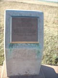
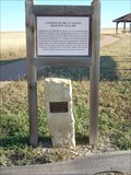 view gallery view galleryS44.7 km | Santa Fe Trail - Campsite of US Survey Team 10-21Sep1825 in Wagon Roads and Trails Limestone marker with a brass plate and a wooden historical marker commemorating the Sibley Survey campsite of 10-21Sep1825. posted by: iconions location: Kansas date approved: 12/02/2008 last visited: 05/01/2020 |
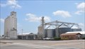
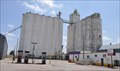
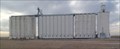 view gallery view galleryS45.4 km |  Howell Dodge City CO-OP Grain Elevators - Dodge City, KS Howell Dodge City CO-OP Grain Elevators - Dodge City, KS
in Grain Elevators The Howell Dodge City CO-OP grain elevator is a testament to the productivity of Kansas farmers - in Dodge City, Kansas. posted by: The Snowdog location: Kansas date approved: 01/01/2023 last visited: never |
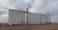 view gallery view galleryS45.4 km |  HOWELL DODGE CITY CO OP ELEV (HH0867) - Dodge City, KS HOWELL DODGE CITY CO OP ELEV (HH0867) - Dodge City, KS
in U.S. Benchmarks The Howell Dodge City CO-OP grain elevator is a U.S. Benchmark - in Dodge City, Kansas. posted by: The Snowdog location: Kansas date approved: 01/03/2023 last visited: never |
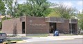 view gallery view galleryS45.7 km |  Cimarron, Kansas 67835 Cimarron, Kansas 67835
in U.S. Post Offices This Post Office is located at 207 N Main Street in Cimarron, Kansas. posted by: brwhiz location: Kansas date approved: 09/01/2012 last visited: 01/05/2023 |
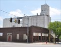 view gallery view galleryS46 km | Cimarron Co-Op Exchange Elevator ~ Cimarron, Kansas in Grain Elevators This older elevator, built sometime around 1950, is located at 122 S Main Street in Cimarron, Kansas. posted by: brwhiz location: Kansas date approved: 06/09/2012 last visited: 01/05/2023 |
 view gallery view galleryS46.2 km | Irsik & Doll Grain Elevators ~ Cimarron, Kansas in Grain Elevators This multiple-elevator grain storage complex is located at 200 S Main Street, in Cimarron, Kansas. posted by: brwhiz location: Kansas date approved: 06/09/2012 last visited: 01/05/2023 |
 view gallery view gallery SW46.5 km SW46.5 km
| Cimarron Crossing - Cimarron, KS in Wagon Roads and Trails This marker indicates where the Santa Fe Trail crossed the Arkansas River - in Cimarron, Kansas. posted by: The Snowdog location: Kansas date approved: 01/05/2023 last visited: never |
 view gallery view galleryS46.7 km |  Cimarron Crossing Park - Cimarron, ,KS Cimarron Crossing Park - Cimarron, ,KS
in Public Playgrounds This beautiful park is managed by the City of Cimarron and by the National Park Service - in Cimarron, Kansas. posted by: The Snowdog location: Kansas date approved: 01/06/2023 last visited: never |
 view gallery view galleryS46.7 km |  Cimarron Crossing Park - Cimarron, KS Cimarron Crossing Park - Cimarron, KS
in Municipal Parks and Plazas Constructed on the site of the historic Cimarron Ranch, Cimarron Crossings Park is part of the National Park Service - in Cimarron, Kansas. posted by: The Snowdog location: Kansas date approved: 01/07/2023 last visited: never |
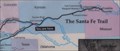
 view gallery view galleryS46.7 km | Santa Fe Trail - Cimmaron, Kansas Trail Map Marker in Wagon Roads and Trails This is a red granite marker in Cimarron Crossing Park just south of Cimarron, Kansas on K-23. posted by: iconions location: Kansas date approved: 12/02/2008 last visited: 01/05/2023 |
 view gallery view galleryS46.7 km | The Santa Fe Trail - Gray County in Kansas Historical Markers This marker is in Cimarron Crossing Park about 1/2 mile south of Cimarron, Kansas on K-23. posted by: iconions location: Kansas date approved: 12/03/2008 last visited: 01/05/2023 |
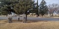
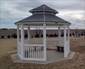 view gallery view gallerySW47 km |  Ingalls Cemetery Gazebo - Ingalls, KS Ingalls Cemetery Gazebo - Ingalls, KS
in Gazebos This pretty white gazebo is in Ingalls Cemetery - northwest of Ingalls, Kansas. posted by: The Snowdog location: Kansas date approved: 01/05/2023 last visited: never |
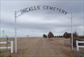 view gallery view gallerySW47 km |  Ingalls-Logan Cemetery - Ingalls, KS Ingalls-Logan Cemetery - Ingalls, KS
in Worldwide Cemeteries This small cemetery is just northwest of Ingalls, Kansas. posted by: The Snowdog location: Kansas date approved: 01/07/2023 last visited: never |
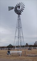 view gallery view gallerySW47 km |  Ingalls Cemetery Windmill - Ingalls, KS Ingalls Cemetery Windmill - Ingalls, KS
in Windmills This windmill once provided water to the cemetery - in Ingalls, Kansas. posted by: The Snowdog location: Kansas date approved: 01/05/2023 last visited: never |
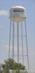 view gallery view gallerySW47.6 km |  Ingalls, Kansas Water Tower Ingalls, Kansas Water Tower
in Water Towers This water tower is directly east of the junction where 4th Avenue ends at Rush Street in Ingalls, Kansas. posted by: brwhiz location: Kansas date approved: 10/04/2012 last visited: 01/06/2023 |
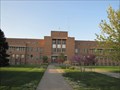 view gallery view galleryS47.8 km | Hennessy Hall, Saint Mary of the Plains Campus - Dodge City, Kansas in U.S. National Register of Historic Places Historic former college building in Dodge City, Kansas posted by:  BruceS BruceS location: Kansas date approved: 06/07/2012 last visited: never |
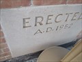 view gallery view galleryS47.8 km |  1952 - Hennessy Hall, Saint Mary of the Plains Campus - Dodge City, Kansas 1952 - Hennessy Hall, Saint Mary of the Plains Campus - Dodge City, Kansas
in Dated Buildings and Cornerstones Historic former college building in Dodge City, Kansas posted by: BruceS location: Kansas date approved: 06/06/2012 last visited: never |
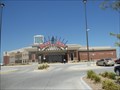 view gallery view galleryS47.8 km |  Boot Hill Casino & Resort - Dodge City, KS Boot Hill Casino & Resort - Dodge City, KS
in Casinos Boot Hill Casino & Resort is located in located in Dodge City, Kansas, USA, and is the first state-owned and operated casino gaming in Kansas. posted by: Marine Biologist location: Kansas date approved: 09/16/2011 last visited: 11/11/2013 |
 view gallery view gallerySW48 km | Ingalls Co-Op Elevator ~ Ingalls, Kansas in Grain Elevators This co-op elevator is located at 6505 US Highway 50 in Ingalls, Kansas. posted by: brwhiz location: Kansas date approved: 06/09/2012 last visited: 01/06/2023 |
|