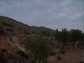
 view gallery view gallery NE6.9 km NE6.9 km
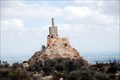
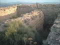
|   CASTILLO DE ORIHUELA CASTILLO DE ORIHUELA
in Castles This ruined castillo is located in Orihuela, Spain. There are concrete references to that it was already constructed in 859. posted by:  Team Agua Team Agua location: Spain date approved: 11/27/2006 last visited: 11/03/2007 |
 view gallery view gallery NW11.4 km NW11.4 km
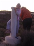
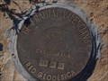
|  Las Carreras Las Carreras
in Vértices Geodésicos Close to Fortuna, Murcia. posted by: Tone location: Spain date approved: 11/19/2006 last visited: 11/19/2006 |
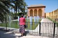
 view gallery view gallery E11.9 km E11.9 km
|  Palacio de Jacarilla - Sundial Palacio de Jacarilla - Sundial
in Sundials This sundial is situated in the garden of the Palacio de Jacarilla.
The Palace and Gardens of The Marques de Cubas y Fontalba is situated in Jacarilla, which is a small town set amongst the orange trees of the beautiful Vega Baja countryside. posted by: El Aguila location: Comunidad Valenciana, Spain date approved: 06/02/2009 last visited: 04/27/2012 |
 view gallery view galleryE12.1 km |  Fountain in the Palace gardens - Jacarilla. Fountain in the Palace gardens - Jacarilla.
in Fountains This modern fountain can be found in the gardens of the old Palace in Jacarilla. posted by: El Aguila location: Comunidad Valenciana, Spain date approved: 04/12/2009 last visited: never |
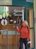 view gallery view gallery SW13.2 km SW13.2 km
|  Oficina Turismo de Murcia Oficina Turismo de Murcia
in Tourist Information Centers - Visitor Centers A tourist office in the historic center of Murcia posted by: Tone location: Región de Murcia, Spain date approved: 12/09/2006 last visited: 12/03/2023 |
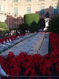 view gallery view gallerySW13.4 km | Fountain in "Plaza glorieta de España" in Fountains This beautifull fountain is placed in "Plaza glorieta de España, in the centrum of Murcia. It has been decorated with beautifull flowers before christmas. posted by: Team Agua location: Spain date approved: 12/09/2006 last visited: 12/03/2023 |
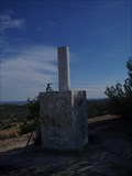
 view gallery view gallery SE14.6 km SE14.6 km
| LA TANGUERA in Vértices Geodésicos En parte superior de trinchera, al E. de ctra A-352 que de Torremendo se dirige a la A-322, San
Miguel de Salinas - Bigastro, a la altura del PK 4.800. posted by: Team Agua location: Spain date approved: 12/09/2006 last visited: never |
 view gallery view galleryNE15 km | Rocamora in Vértices Geodésicos En puente sobre autovía Alicante - Murcia. posted by: Team Agua location: Spain date approved: 12/10/2006 last visited: never |
 view gallery view galleryE16.9 km | Geodesic - Campo de Tiro - Algorfa in Vértices Geodésicos The geodesic is a short distance from my geocache 'Campo de Tiro.'
Situado en el punto más alto de la loma de la 'Escotera de Algorfa'
posted by: El Aguila location: Comunidad Valenciana, Spain date approved: 04/14/2009 last visited: 04/10/2009 |
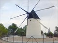
 view gallery view gallery S17.9 km S17.9 km
| Molino in Vértices Geodésicos En un alto al S. de la carretera, en las inmediaciones del pueblo de Sucina. La señal se encuentra en el interior de una finca particular cercada junto a un molino de viento, sobre estratos calizos. posted by: Team Agua location: Spain date approved: 11/24/2006 last visited: 11/25/2006 |
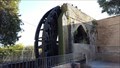 view gallery view gallery W18.2 km W18.2 km
|  Rueda de la Ñora (Water mill) - Molino de los Casianos, Murcia, Spain Rueda de la Ñora (Water mill) - Molino de los Casianos, Murcia, Spain
in Working Water Wheels La Rueda de la Ñora es uno de los monumentos históricos del río Segura en Murcia. Fue construido en tiempos de la dominación árabe y sigue siendo un instrumento útil de regadío en la huerta de Murcia. ¡Hazte una foto y muestra tu entusiasmo! posted by: Adsum74 location: Región de Murcia, Spain date approved: 07/17/2019 last visited: never |
 view gallery view galleryE19.2 km | Modern, Sculptural Fountain - La Finca Golf - Algorfa in Fountains This fountain is situated on a roundabout by La finca Golf urbanisation, Algorfa. It looks quite spectacular when working. posted by: El Aguila location: Comunidad Valenciana, Spain date approved: 07/16/2009 last visited: never |
 view gallery view gallerySE20.1 km | Campoverde in Vértices Geodésicos In the middel of the Urb. El Pinar de Campoverde. posted by: Tone location: Spain date approved: 11/23/2006 last visited: 11/24/2006 |
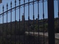
 view gallery view gallerySW20.8 km | Castillo del Puerto de la Cadena in Castles In ruins of 12th Century Arab hilltop fort - Castillo del Puerto de la Cadena. posted by: Team Agua location: Spain date approved: 11/28/2006 last visited: 12/23/2006 |
 view gallery view gallerySE21.2 km | La Vieja in Vértices Geodésicos Situado en el punto más alto del cabezo de "La Vieja", San Miguel de Salinas
posted by: Team Agua location: Spain date approved: 11/22/2006 last visited: 11/23/2006 |
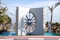
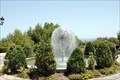 view gallery view gallerySE23.5 km | Golf Campoamor Fountain in Fountains The fountain resembles a dandelion seed head. posted by: El Aguila location: Comunidad Valenciana, Spain date approved: 06/12/2009 last visited: never |
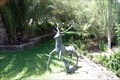 view gallery view gallerySE23.7 km |  Stag amongst palms and trees - Golf Campoamor. Stag amongst palms and trees - Golf Campoamor.
in Figurative Public Sculpture Statue of a deer in amongst trees at Golf Campoamor. posted by: El Aguila location: Comunidad Valenciana, Spain date approved: 06/12/2009 last visited: never |
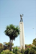 view gallery view gallerySE23.7 km | Golfer at Golf Campoamor Hotel complex. in Figurative Public Sculpture Golfer Statue on top of a column. posted by: El Aguila location: Comunidad Valenciana, Spain date approved: 06/12/2009 last visited: never |
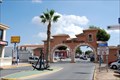 view gallery view galleryE24 km |  Anchor - Ciudad Quesada Arches Anchor - Ciudad Quesada Arches
in Anchors This anchor is situated by 'The Arches' - a well known, local, landmark - on the urbanisation, Ciudad Quesada posted by: El Aguila location: Comunidad Valenciana, Spain date approved: 09/18/2009 last visited: 04/27/2012 |
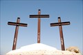 view gallery view galleryE24.3 km |  Crosses of Rojales. Crosses of Rojales.
in Christian Crosses Three crosses overlooking Rojales with smaller ones representing the Stations of the Cross. posted by: El Aguila location: Comunidad Valenciana, Spain date approved: 04/11/2009 last visited: 03/26/2009 |
 view gallery view galleryE25.9 km | Salinas de Torrevieja in Vértices Geodésicos Very close to the Salt Lake in Torrevieja. posted by: Tone location: Spain date approved: 11/23/2006 last visited: 11/23/2006 |
 view gallery view galleryNE27.8 km |  CEMACAM Los Molinos.Crevillent.Spain CEMACAM Los Molinos.Crevillent.Spain
in Windmills Molino de viento cartagenero ubicado en el Centro Medio Ambiental "Los Molinos" posted by:  noonmoon noonmoon location: Comunidad Valenciana, Spain date approved: 12/12/2009 last visited: 04/19/2010 |
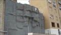 view gallery view galleryNE28 km |  muro de escalada Artificial -La Rambla muro de escalada Artificial -La Rambla
in Artificial Climbing Walls Muro de Escalada Artificial. Localizacion Crevillente. Alicante, Spain. posted by: nomadarasta location: Comunidad Valenciana, Spain date approved: 12/14/2009 last visited: 03/23/2017 |
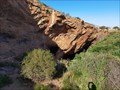 view gallery view galleryS28.3 km |  Cabezo Gordo - Torre Pacheco, Murcia, España Cabezo Gordo - Torre Pacheco, Murcia, España
in Wikipedia Entries El cabezo Gordo es una elevación de 312 metros de altura situada en la depresión litoral del Campo de Cartagena, en el municipio de Torre Pacheco en la Región de Murcia (España). posted by: GURUGU location: Región de Murcia, Spain date approved: 03/17/2024 last visited: 06/05/2024 |
 view gallery view galleryNE28.6 km |  La Vella Orientation Table. Sierra de Crevillent. Alicante.Spain La Vella Orientation Table. Sierra de Crevillent. Alicante.Spain
in Orientation Tables Orientation table located on the highest point of the Sierra de Crevillent.España
Mesa de Orientación situada en el punto mas alto de la sierra de Crevillent.España
posted by: noonmoon location: Comunidad Valenciana, Spain date approved: 11/27/2009 last visited: 08/25/2013 |
|