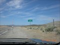
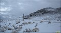
 view gallery view gallery N28.5 km N28.5 km
|   Warm Springs Summit - Nevada Warm Springs Summit - Nevada
in Elevation Signs Along US Route 6, in central Nevada. posted by:  shadow101 shadow101 location: Nevada date approved: 06/24/2012 last visited: 11/22/2013 |
 view gallery view gallery SE30.1 km SE30.1 km
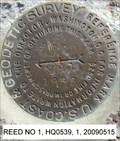
|  REED RM 1, HQ0539 - Nye County, Nevada REED RM 1, HQ0539 - Nye County, Nevada
in U.S. Benchmarks A reference mark disk. posted by:  nvtriker nvtriker location: Nevada date approved: 05/15/2009 last visited: never |
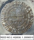 view gallery view gallerySE30.1 km | REED RM 2, HQ0538 - Nye County, Nevada in U.S. Benchmarks A reference mark disk. posted by: nvtriker location: Nevada date approved: 05/15/2009 last visited: never |
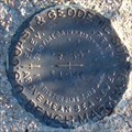
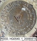 view gallery view gallerySE30.1 km | REED 1933, HQ0540 - Nye County, Nevada in U.S. Benchmarks A triangulation station disk. posted by: nvtriker location: Nevada date approved: 05/15/2009 last visited: never |
 view gallery view galleryN31.1 km |  Warm Springs, Nevada Warm Springs, Nevada
in Wikipedia Entries Warm Springs a town in Nye County Nevada. posted by: nvtriker location: Nevada date approved: 04/26/2009 last visited: 06/08/2016 |
 view gallery view galleryN31.1 km |  Warm Springs, Nevada Warm Springs, Nevada
in Ghost Towns This settlement has been completely abandoned since abount 1990. posted by: Queens Blessing location: Nevada date approved: 12/05/2012 last visited: 11/08/2015 |
 view gallery view galleryN31.1 km |  Warm Springs Pound, Nye County, Nevada Warm Springs Pound, Nye County, Nevada
in Town and Village Pounds Warm Springs is a ghost town visible from the hiway and has a rock pound. posted by: Queens Blessing location: Nevada date approved: 12/02/2012 last visited: 10/14/2019 |
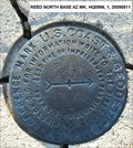 view gallery view gallery E36.2 km E36.2 km
|  REED N B AZI - Nevada REED N B AZI - Nevada
in Azimuth Benchmarks An Azimuth Mark for REED NORTH BASE. posted by: nvtriker location: Nevada date approved: 07/14/2012 last visited: never |
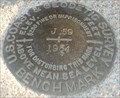 view gallery view gallerySE36.4 km | J 59, Nye County Nevada in U.S. Benchmarks A standard benchmark disk posted by: nvtriker location: Nevada date approved: 04/20/2009 last visited: never |
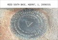 view gallery view gallerySE36.9 km | REED SOUTH BASE, Nye county Nevada in U.S. Benchmarks A TRIANGULATION STATION DISK posted by: nvtriker location: Nevada date approved: 04/20/2009 last visited: never |
 view gallery view gallerySE44.3 km | F 59, Nye county Nevada in U.S. Benchmarks A standard benchmark disk posted by: nvtriker location: Nevada date approved: 04/20/2009 last visited: 01/05/2023 |
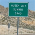 view gallery view gallerySE44.3 km | QUEEN CITY SUMMIT 5960 - Nevada in Elevation Signs A pass on SR375 posted by: nvtriker location: Nevada date approved: 05/07/2009 last visited: 01/05/2023 |
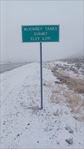 view gallery view gallery NW49.2 km NW49.2 km
| 6391 - McKinney Tanks - Nye County, NV in Elevation Signs This elevation sign for McKinney Tanks is on the east side of Highway 6 - in Nye County, Nevada. posted by: The Snowdog location: Nevada date approved: 01/05/2023 last visited: never |
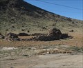
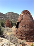 view gallery view galleryN51.2 km |  Charcoal Kilns for Tybo Nevada - USA Charcoal Kilns for Tybo Nevada - USA
in Ovens and Kilns Two Charcoal Kilns were built in the 1874 for mining in Tybo, NV. posted by: philbeer location: Nevada date approved: 08/19/2013 last visited: 04/19/2014 |
 view gallery view galleryN51.2 km | Charcoal Kilns for Tybo Nevada - USA in Wikipedia Entries Two Charcoal Kilns were built in the 1874 for mining in Tybo, NV. posted by: philbeer location: Nevada date approved: 08/19/2013 last visited: 04/22/2014 |
 view gallery view galleryN51.2 km |  Tybo Charcoal Kilns- Nye County, Nevada - USA Tybo Charcoal Kilns- Nye County, Nevada - USA
in U.S. National Register of Historic Places Two Charcoal Kilns were built in the 1874 for mining in Tybo, NV. posted by: philbeer location: Nevada date approved: 08/19/2013 last visited: 04/19/2014 |
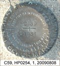 view gallery view gallerySE53.1 km | C59, HP0254 - Rachel, Nevada in U.S. Benchmarks A standard benchmark disk stamped C59 posted by: nvtriker location: Nevada date approved: 08/09/2009 last visited: never |
 view gallery view gallerySE56.2 km | B 59, NEVADA in U.S. Benchmarks A standard benchmark disk posted by: nvtriker location: Nevada date approved: 04/20/2009 last visited: 01/05/2023 |
 view gallery view gallery W56.2 km W56.2 km
|  Tonopah Test Range, Tonopah, NV Tonopah Test Range, Tonopah, NV
in Static Artillery Displays The Tonopah Test Range airfield came into existence in 1957 and was largely used by the Department of Energy, the Air Force, and several contractors. posted by: Poehunters location: Nevada date approved: 07/15/2013 last visited: 01/05/2023 |
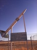
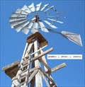 view gallery view gallerySE56.2 km | HP0392 WINDMILL 2 LINCOLN COUNTY NEVADA in U.S. Benchmarks A WOODEN FRAMED WINDMILL posted by: nvtriker location: Nevada date approved: 04/18/2009 last visited: 01/05/2023 |
 view gallery view gallerySE56.2 km |  WINDMILL 2, Rachel Nevada WINDMILL 2, Rachel Nevada
in Windmills A WOODEN FRAMED WINDMILL posted by: nvtriker location: Nevada date approved: 04/21/2009 last visited: 01/05/2023 |
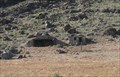
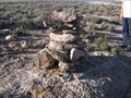 view gallery view galleryN57.3 km |  Hot Creek Range Cairn, Nye County, Nevada Hot Creek Range Cairn, Nye County, Nevada
in Cairns This cairn is on a National Forest Service Road. posted by: Queens Blessing location: Nevada date approved: 12/02/2012 last visited: 07/07/2014 |
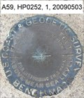 view gallery view gallerySE59.2 km | A59, HP0252, Lincoln County Nevada in U.S. Benchmarks A standard benchmark disk posted by: nvtriker location: Nevada date approved: 05/05/2009 last visited: 04/21/2014 |
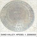 view gallery view gallerySE59.4 km | SAND VALLEY, HP0393, Rachel Nevada in U.S. Benchmarks A triangulation station disk. posted by: nvtriker location: Nevada date approved: 05/05/2009 last visited: never |
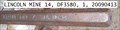 view gallery view galleryE60 km | LINCOLN MINE 14, DF3580, 1963, NEVADA in U.S. Benchmarks A 1 INCH DRILL STEEL CEMENTED IN ROCK OUTCROP AND PROTRUDING 1.1 FT ABOVE GROUND posted by: nvtriker location: Nevada date approved: 04/18/2009 last visited: 09/02/2012 |
|