 view gallery view gallery SE2.9 km SE2.9 km
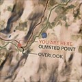
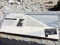
|   Olmsted Point Map - Yosemite, CA Olmsted Point Map - Yosemite, CA
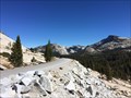
in 3D Map Models of Our World and Beyond A 3d map of Yosemite Valley at Olmsted Point. posted by:  bluesnote bluesnote location: California date approved: 10/21/2016 last visited: 10/21/2016 |
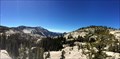
 view gallery view gallerySE2.9 km |  Olmsted Point - Yosemite, CA Olmsted Point - Yosemite, CA
in Bookcrossing Zones A popular vista point along Tioga Pass Rd within Yosemite National Park. posted by: bluesnote location: California date approved: 01/12/2017 last visited: 01/12/2017 |
 view gallery view gallerySE2.9 km |  Olmsted Point - Yosemite, CA Olmsted Point - Yosemite, CA
in Wikipedia Entries A popular vista point along Tioga Pass Rd within Yosemite National Park. posted by: bluesnote location: California date approved: 10/21/2016 last visited: 10/21/2016 |
 view gallery view gallerySE2.9 km |  Olmsted Point - Yosemite, CA Olmsted Point - Yosemite, CA
in Scenic Roadside Look-Outs A popular vista point along Tioga Pass Rd within Yosemite National Park. posted by: bluesnote location: California date approved: 10/21/2016 last visited: 10/21/2016 |
 view gallery view gallerySE2.9 km |  Olmsted Point - Yosemite, CA Olmsted Point - Yosemite, CA
in Scenic Overlooks A popular vista point along Tioga Pass Rd within Yosemite National Park. posted by: bluesnote location: California date approved: 10/20/2016 last visited: 10/20/2016 |
 view gallery view gallerySE2.9 km |  Olmsted Point Trail - Yosemite, CA Olmsted Point Trail - Yosemite, CA
in Long Distance Hiking Trails A long distance hiking trail on the north side of Yosemite National Park. posted by: bluesnote location: California date approved: 10/20/2016 last visited: 10/20/2016 |
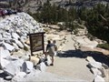
 view gallery view gallerySE2.9 km |  Olmsted Point Trail Map - Yosemite, CA Olmsted Point Trail Map - Yosemite, CA
in 'You Are Here' Maps A tail map at Olmsted Point in Yosemite National Park. posted by: bluesnote location: California date approved: 10/21/2016 last visited: 10/21/2016 |
 view gallery view gallerySE2.9 km |  Olmsted Point Trail - Yosemite, CA Olmsted Point Trail - Yosemite, CA
in Hiking and walking trailheads A long distance hiking trail on the north side of Yosemite National Park. posted by: bluesnote location: California date approved: 11/02/2016 last visited: 11/02/2016 |
 view gallery view gallerySE2.9 km | Tioga Pass - Yosemite, CA in Wikipedia Entries The Tioga Pass is the northern most route into Yosemite Valley. It is also the highest, with parts in excess of 9,000 feet in elevation. posted by: bluesnote location: California date approved: 10/21/2016 last visited: 07/24/1984 |
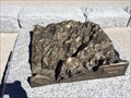
 view gallery view gallerySE2.9 km |  Avalanche! - Yosemite, CA Avalanche! - Yosemite, CA
in Signs of History One of a few signs of history at Olmsted Point within Yosemite National Park. posted by: bluesnote location: California date approved: 10/20/2016 last visited: 10/20/2016 |
 view gallery view gallery S10.1 km S10.1 km
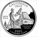
|  Half Dome - Yosemite National Park Half Dome - Yosemite National Park
in Numismatic Photographs Issued as part of the United States Mint's 50 State Quarters Program, the California State Quarter first appeared in 2005, the 31st state quarter to be released (to match California being the 31st state admitted to the USA). posted by: DougK location: California date approved: 11/26/2011 last visited: 01/03/2014 |
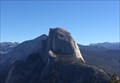
 view gallery view galleryS10.3 km |  Half Dome - Yosemite, CA Half Dome - Yosemite, CA
in Established Rock Climbing Areas Named one of the hardest rock climbing places in the world, half dome features nearly 4,000 vertical feet of pure granite that requires at least an overnight stay while suspended thousands of feet above Yosemite Valley. posted by: bluesnote location: California date approved: 07/13/2017 last visited: 08/01/2023 |
 view gallery view galleryS10.3 km |  Half Dome - Yosemite, CA Half Dome - Yosemite, CA
in Satellite Imagery Oddities Half Dome in Yosemite National Park. posted by: bluesnote location: California date approved: 01/11/2017 last visited: 08/01/2023 |
 view gallery view galleryS10.3 km | Half Dome - Yosemite, CA in Wikipedia Entries Half Dome in Yosemite National Park. posted by: bluesnote location: California date approved: 01/14/2017 last visited: 08/01/2023 |
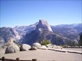 view gallery view galleryS10.3 km |  Half Dome Half Dome
in Mountain Summits An iconic mountain in Yosemite Valley. It's hard to go through the gift shops in Yosemite Valley without seeing the image of this mountain emblazoned on t-shirts, coffee mugs and even shot glasses. Indeed, the National Park Service is so enamored of this mountain that they use a graphic designed silhouette of this mountain as their logo to represent the Park.
posted by: Touchstone location: California date approved: 09/20/2006 last visited: 08/01/2023 |
 view gallery view galleryS10.3 km |  Half Dome - Yosemite, CA Half Dome - Yosemite, CA
in Official Local Tourism Attractions Half Dome in Yosemite National Park. posted by: bluesnote location: California date approved: 11/08/2017 last visited: 08/01/2023 |
 view gallery view galleryS10.3 km |  Half Dome - Yosemite, CA Half Dome - Yosemite, CA
in American Guide Series Half Dome in Yosemite National Park. posted by: bluesnote location: California date approved: 11/14/2017 last visited: 05/03/2022 |
 view gallery view galleryS10.3 km |  Half Dome - "Buckaroos Amok" - Yosemite NP, CA Half Dome - "Buckaroos Amok" - Yosemite NP, CA
in Zippy the Pinhead Locations In this Zippy comic strip, several Yosemite Sam characters appears in a Zippy-style polka dotted muumuu. posted by: DougK location: California date approved: 10/10/2012 last visited: 08/01/2023 |
 view gallery view gallery SW10.5 km SW10.5 km
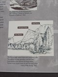
|  Mirror Lake Trail Orientation Table - Yosemite National Park CA USA Mirror Lake Trail Orientation Table - Yosemite National Park CA USA
in Orientation Tables Orientation table along the Mirror Lake self-guided trail posted by:  fishingwishing fishingwishing location: California date approved: 03/17/2009 last visited: 03/30/2014 |
 view gallery view gallerySW10.5 km | Mirror Lake trail - Yosemite National Park, CA in Scenic Hikes While in Yosemite National park, we had the opportunity to do the Mirror Lake trail. Really worthwhile doing! You can do the "longer" hike (5 miles) or the shorter one (2 miles). Make sure to bring enough water / food. posted by: T-Team! location: California date approved: 06/18/2022 last visited: never |
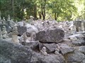 view gallery view gallerySW10.5 km |  Better than Balancing a Budget Better than Balancing a Budget
in Sculpture Gardens Rock Garden by Mirror Lake posted by: Gemste location: California date approved: 09/14/2011 last visited: 03/30/2014 |
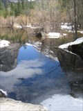 view gallery view gallerySW10.6 km |  Mirror Lake Self-Guided Trail - Yosemite National Park, CA USA Mirror Lake Self-Guided Trail - Yosemite National Park, CA USA
in Self Guided Walks and Trails An easy stroll beside Mirror Lake providing history of the area as well as some of the best views of the Valley walls posted by: fishingwishing location: California date approved: 03/16/2009 last visited: 03/30/2014 |
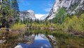
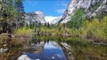 view gallery view gallerySW10.6 km |  Mirror Lake Mt Watkins - Yosemite National Park, CA, USA Mirror Lake Mt Watkins - Yosemite National Park, CA, USA
in Ansel Adams Photo Hunt When enjoying the sights at Yosemite, make sure that also walk up to Mirror lake. A lovely walk and a great spot to see this fantastic photo spot. posted by: T-Team! location: California date approved: 05/30/2022 last visited: never |
 view gallery view gallery NE10.8 km NE10.8 km
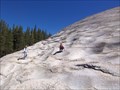
|  Pothole Dome Pothole Dome
in Places of Geologic Significance Pothole Dome in Tuolumne Meadows provides an excellent opportunity to view typical glacial erosional and geomorphologic features and some not so typical ones as well. posted by: TerryDad2 location: California date approved: 01/03/2010 last visited: 02/20/2015 |
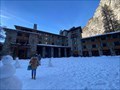 view gallery view gallerySW11.7 km | Ahwahnee Hotel - Yosemite National Park, California in Wikipedia Entries A historic hotel in Yosemite National Park, California. posted by: saopaulo1 location: California date approved: 03/02/2022 last visited: 03/12/2022 |
|