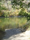
 view gallery view gallery W0.5 km W0.5 km
|   Kentucky River near Lock 7, High Bridge, KY Kentucky River near Lock 7, High Bridge, KY
in Boat Ramps Small private ramp available for use for a fee. Just above Lock 7 on the Kentucky River, near High Bridge. posted by:  kbarhow kbarhow location: Kentucky date approved: 11/23/2008 last visited: never |
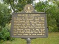 view gallery view gallery SW0.6 km SW0.6 km
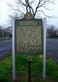
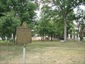
|  Shaker Landing, Pleasant Hill, KY Shaker Landing, Pleasant Hill, KY
in Kentucky Historical Markers Former river crossing and landing near the old Shaker colony known as Pleasant Hill. posted by: kbarhow location: Kentucky date approved: 11/24/2008 last visited: never |
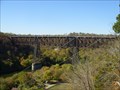 view gallery view gallery S0.6 km S0.6 km
|  High Bridge of Kentucky - near Wilmore, KY High Bridge of Kentucky - near Wilmore, KY
in Railroad Bridges Active rail bridge over the Kentucky River. posted by: kbarhow location: Kentucky date approved: 11/24/2008 last visited: 01/16/2009 |
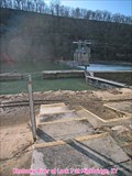 view gallery view gallery NW0.8 km NW0.8 km
|  Kentucky River at Lock 7 at Highbridge, Jessamine County, KY Kentucky River at Lock 7 at Highbridge, Jessamine County, KY
in River Gauges USGS Gauge 03286500. posted by: wuja location: Kentucky date approved: 03/06/2008 last visited: 01/16/2009 |
 view gallery view galleryW2.1 km | Shakertown at Pleasant Hill in Kentucky Historical Markers Shakertown at Pleasant Hill posted by: SportsPhotoGuy location: Kentucky date approved: 04/21/2009 last visited: 06/21/2010 |
 view gallery view gallery NE4.2 km NE4.2 km
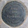
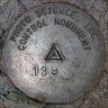
|  C 410 RESET, AJ8430, Jessamine County, KY C 410 RESET, AJ8430, Jessamine County, KY
in U.S. Benchmarks Vertical control disk in bridge abutment. posted by: wuja location: Kentucky date approved: 03/06/2008 last visited: never |
 view gallery view galleryNE4.3 km | N N 9 at Pump Station Road, Wilmore, KY in U.S. Benchmarks About halfway down the Pump Station Road and at the west edge of an intermediate station of water pipeline from Kentucky River to Wilmore. The mark is located in the Asbury Trails preserve. posted by: wuja location: Kentucky date approved: 04/30/2007 last visited: never |
 view gallery view gallery N6.3 km N6.3 km
| Woodford County 139 in U.S. Benchmarks Versailles-Midway-Woodford County Planning Commission Monument. posted by: wuja location: none listed yet date approved: 05/15/2007 last visited: never |
 view gallery view galleryNE6.4 km |  Water Tower - Wilmore, KY Water Tower - Wilmore, KY
in Water Towers This water tower is on a hill behind the phyisical education building on the campus of Asbury College overlooking the town of Wilmore, Kentucky. A cross is mounted on the top of the tower. posted by:  silverquill silverquill location: Kentucky date approved: 01/18/2008 last visited: 08/22/2023 |
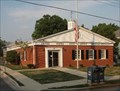 view gallery view galleryNE6.4 km |  Wilmore, KY 40309 Wilmore, KY 40309
in U.S. Post Offices Wilmore, Kentucky, located south of Lexington, is home to Asbury College and Asbury Theological Seminary. The post office is located in the historic downtown district. posted by: silverquill location: Kentucky date approved: 10/03/2007 last visited: 12/02/2008 |
 view gallery view galleryNE6.4 km |  Wilmore, KY Wilmore, KY
in City and Town Halls This old stone building, located in the Main Street Historic District, serves as the city hall and police station for the town of Wilmore, Kentucky, best known as home of Asbury College and Asbury Seminary. posted by: silverquill location: Kentucky date approved: 02/03/2009 last visited: never |
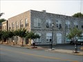 view gallery view galleryNE6.4 km |  Police Department - Wilmore, KY Police Department - Wilmore, KY
in Police Stations This unique stone building houses the town offices and the police department for the college town of Wilmore, Kentucky, home of Asbury College and Asbury Theological Seminary. posted by: silverquill location: Kentucky date approved: 01/18/2008 last visited: 01/15/2017 |
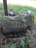
 view gallery view galleryN6.4 km |  Jessamine-Woodford Counties Boundary Monument on Pekin/Troy Pike, KY Jessamine-Woodford Counties Boundary Monument on Pekin/Troy Pike, KY
in U.S. Historic Survey Stones and Monuments Concrete post with letter 'J' on the Jessamine County side and letter 'W' on the Woodford County side. Out of the ground and lying flat. Shown as a boundary monument on the Keene, KY 7.5' topo. posted by: wuja location: Kentucky date approved: 05/14/2007 last visited: never |
 view gallery view gallerySW6.6 km | Neighbors-Governors / Mercer Governors, Harrodsburg, Kentucky in Kentucky Historical Markers Kentucky Governors posted by: krsmith2 location: Kentucky date approved: 08/31/2013 last visited: never |
 view gallery view galleryNE6.6 km | Asbury College/Bethel Academy - Wilmore, KY in Kentucky Historical Markers Asbury College/Bethel Academy, Marker #1830 is located at the entrance to the campus in Wilmore, Kentucky. posted by: silverquill location: Kentucky date approved: 10/04/2007 last visited: 12/18/2012 |
 view gallery view galleryN6.6 km | Woodford County 139A in U.S. Benchmarks Versailles-Midway-Woodford County Planning Commission Monument. posted by: wuja location: none listed yet date approved: 05/15/2007 last visited: never |
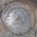
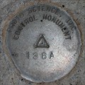 view gallery view galleryN7.7 km | Woodford County 136A in U.S. Benchmarks Versailles-Midway-Woodford County Planning Commission Monument. posted by: wuja location: none listed yet date approved: 05/15/2007 last visited: never |
 view gallery view gallerySW8.5 km | Gabriel Slaughter, 1767-1830, Harrodsburg, Kentucky 40330 in Kentucky Historical Markers Lieutenant governor and acting governor posted by: krsmith2 location: Kentucky date approved: 09/02/2013 last visited: never |
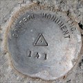 view gallery view galleryN8.7 km | Woodford County 141 in U.S. Benchmarks Versailles-Midway-Woodford County Planning Commission Monument. posted by: wuja location: none listed yet date approved: 05/15/2007 last visited: never |
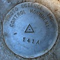 view gallery view galleryN9 km | Woodford County 141A in U.S. Benchmarks Versailles-Midway-Woodford County Planning Commission Monument. posted by: wuja location: none listed yet date approved: 05/15/2007 last visited: never |
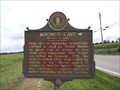 view gallery view gallerySW9 km |  Boone's Cave, Harrodsburg, Kentucky Boone's Cave, Harrodsburg, Kentucky
in First of its Kind John Stuart, first recorded white man killed by Indians in Ky. posted by: krsmith2 location: Kentucky date approved: 09/01/2013 last visited: never |
![Image for Boone's Cave [Not Open To Public], Harrodsburg, Kentucky 40330](https://img.geocaching.com/waymarking/small/b2428ccc-8a81-484b-b967-5f8a3773e0bc.JPG) view gallery view gallerySW9 km | Boone's Cave [Not Open To Public], Harrodsburg, Kentucky 40330 in Kentucky Historical Markers Only cave in Kentucky historically verified as used by Daniel Boone.
Not Open To Public posted by: krsmith2 location: Kentucky date approved: 09/02/2013 last visited: never |
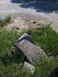 view gallery view galleryN9.2 km | Jessamine-Woodford Counties Boundary Monument on Troy Rd, KY in U.S. Historic Survey Stones and Monuments Dressed stone with letter 'W' on the Woodford County side. Jessamine County side is damaged and unreadable. Shown as a boundary monument on the Keene, KY 7.5' topo. posted by: wuja location: Kentucky date approved: 05/14/2007 last visited: never |
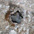 view gallery view gallery SE9.5 km SE9.5 km
| BM 860, Garrard County, KY in U.S. Benchmarks Only the stem remains. Shown as a vertical control BM 860 on Wilmore, KY topo quad. posted by: wuja location: Kentucky date approved: 09/17/2007 last visited: never |
 view gallery view galleryN10 km | Jessamine-Woodford Counties Boundary Monument on Keene-Troy Rd/Pike, KY in U.S. Historic Survey Stones and Monuments Dressed stone with letter 'J' on the Jessamine County side. Woodford County side is damaged and unreadable. Shown as a boundary monument on the Keene, KY 7.5' topo. posted by: wuja location: Kentucky date approved: 05/14/2007 last visited: never |
|