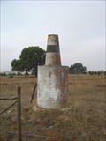
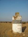
 view gallery view gallery E5.3 km E5.3 km
|   CUCHILHAS CUCHILHAS
in Portugal Geodetic Points Nome do Vértice: CUCHILHAS
Coordenadas: N 37° 43.163 W007° 53.567 posted by:  MightyReek MightyReek location: Beja, Portugal date approved: 10/02/2009 last visited: never |
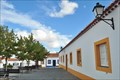 view gallery view gallery NW7.2 km NW7.2 km
|  Biblioteca Municipal Manuel da Fonseca Polo de Entradas - Entradas, Portugal Biblioteca Municipal Manuel da Fonseca Polo de Entradas - Entradas, Portugal
in Libraries This is a village's branch of the municipality library. posted by: Torgut location: Beja, Portugal date approved: 11/22/2014 last visited: never |
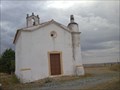
 view gallery view galleryNW7.2 km | Entradas in Portugal Geodetic Points Church tower posted by:  Vedot67 Vedot67 location: Beja, Portugal date approved: 06/04/2012 last visited: never |
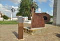
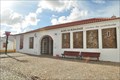 view gallery view galleryNW7.4 km |  Museu da Ruralidade - Entradas, Portugal Museu da Ruralidade - Entradas, Portugal
in History Museums A small museum in a nice village (Entradas) posted by: Torgut location: Beja, Portugal date approved: 09/01/2015 last visited: never |
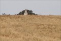
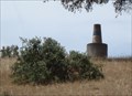
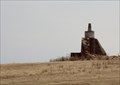 view gallery view gallery W8 km W8 km
| Pereiros in Portugal Geodetic Points On the top of the old windmill posted by: Vedot67 location: Beja, Portugal date approved: 06/04/2012 last visited: never |
 view gallery view gallery SW9.8 km SW9.8 km
|  Batalha de Ourique, Portugal Batalha de Ourique, Portugal
in Battlefields The Battle of Ourique (25 July 1139: St. James Day) saw the forces of Portuguese Prince Afonso Henriques (of the House of Burgundy) defeat the Almoravid Moors led by Ali ibn Yusuf. posted by: ajsa location: Beja, Portugal date approved: 11/06/2011 last visited: never |
 view gallery view gallery N10.3 km N10.3 km
| Escudeiros in Portugal Geodetic Points Mark without access, in the middle of the field. posted by: Vedot67 location: Beja, Portugal date approved: 06/04/2012 last visited: 01/11/2016 |
 view gallery view galleryW10.5 km | Portela da Sortelha in Portugal Geodetic Points A mark close to IP2 road. posted by: Vedot67 location: Beja, Portugal date approved: 06/04/2012 last visited: never |
 view gallery view galleryW12.2 km |  Monumento Evocativo da Batalha de Ourique - Castro Verde, Portugal Monumento Evocativo da Batalha de Ourique - Castro Verde, Portugal
in Abstract Public Sculptures A sculpture commemorating a battle which took place to far but a long time ago. posted by: Torgut location: Beja, Portugal date approved: 09/03/2015 last visited: never |
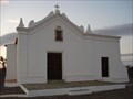
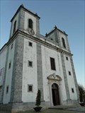 view gallery view galleryW12.2 km | ") Igreja Matriz de Castro Verde - Castro Verde, Portugal Igreja Matriz de Castro Verde - Castro Verde, Portugal
in Património Português (Portuguese Heritage) The parish Church of Castro Verde, also known as Royal Basilica of Castro Verde, was declared as a public interest building on November 30th, 1993. posted by: tmob location: Beja, Portugal date approved: 02/11/2012 last visited: never |
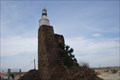
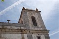 view gallery view galleryW12.2 km | Castro in Portugal Geodetic Points Church tower in Castro Verde posted by: Vedot67 location: Beja, Portugal date approved: 06/04/2012 last visited: never |
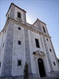 view gallery view galleryW12.2 km |  Basilica de Castro Verde, Beja, PT Basilica de Castro Verde, Beja, PT
in Roman Catholic Churches Castro Verde Basilica, one beautiful big church that dominates the landscape all around it.
Inside you can see nice 18th century hand painted tiles, with images of the Battle of Ourique, a very important portuguese historic event related to the founding of Portugal. posted by: mtrevas location: Beja, Portugal date approved: 06/02/2010 last visited: 11/21/2014 |
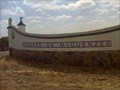
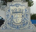 view gallery view galleryW12.2 km |  Castro Verde, Portugal Castro Verde, Portugal
in Pictorial Village Signs Castro Verde is a municipality in Alentejo Region of Portugal, District of Beja, with a total area of 569.44 km² and population of 7702 inhabitants (2006) posted by: tmob location: Beja, Portugal date approved: 12/04/2011 last visited: never |
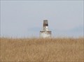
 view gallery view gallerySW13.7 km | Montes da Vinha in Portugal Geodetic Points Mark by a paved road posted by: Vedot67 location: Beja, Portugal date approved: 06/04/2012 last visited: never |
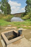 view gallery view gallery SE17.1 km SE17.1 km
|  Água Santa da Herdade - Mértola, Portugal Água Santa da Herdade - Mértola, Portugal
in Natural Springs A beautiful place with a natural spring posted by: Torgut location: Beja, Portugal date approved: 09/14/2012 last visited: never |
 view gallery view galleryW17.2 km | S. Sebastião in Portugal Geodetic Points Marco Geodésico de 2ª Ordem.
Cordenadas:
N 37° 43.913
W 008° 08.707 posted by: MightyReek location: Beja, Portugal date approved: 10/02/2009 last visited: never |
 view gallery view gallery NE18 km NE18 km
| MARCO QUEBRADO in Portugal Geodetic Points Vértice Geodésico: MARCO QUEBRADO
Coordenadas: N 37° 52.796 W007° 51.877 posted by: MightyReek location: Beja, Portugal date approved: 10/02/2009 last visited: 04/10/2012 |
 view gallery view gallery S20.4 km S20.4 km
|  Herdade de Miguenzes - Mértola, Portugal Herdade de Miguenzes - Mértola, Portugal
in Named Farms and Ranches Herdade de Miguenzes is a huge property in Southern Portugal posted by: Torgut location: Beja, Portugal date approved: 09/16/2012 last visited: never |
 view gallery view gallerySW20.8 km | Neves in Portugal Geodetic Points On the top of the windmill. posted by: Vedot67 location: Beja, Portugal date approved: 06/04/2012 last visited: never |
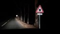 view gallery view gallerySE20.9 km |  Iberian lynx (Lynx pardinus) Crossing Sign - Mértola, Portugal Iberian lynx (Lynx pardinus) Crossing Sign - Mértola, Portugal
in Uncommon Crossing Signs This sign, and his opposite, a few kilometers from this one, can be found in a secondary road, linking Castro Verde to Mertola. posted by: RuiJSDuarte location: Beja, Portugal date approved: 08/31/2016 last visited: never |
 view gallery view galleryS21.4 km | Semblana in Portugal Geodetic Points By a village of Semblana, the mark on the top of abandoned windmill. posted by: Vedot67 location: Beja, Portugal date approved: 06/04/2012 last visited: never |
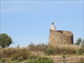
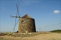 view gallery view gallerySE23.2 km |  S. Miguel do Pinheiro, Almodôvar, Portugal S. Miguel do Pinheiro, Almodôvar, Portugal
in Windmills A nice windmill in a remote village of Southern Portugal posted by: Torgut location: Faro, Portugal date approved: 08/26/2012 last visited: never |
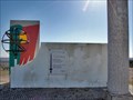
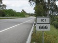 view gallery view galleryW24.5 km |  IC1, Km 666, Beja, Portugal IC1, Km 666, Beja, Portugal
in 666 Sightings IC1 is the road that connects Lisbon to the Algarve. This is Km 666, as signed by the roadside marker, near Ourique. posted by: btrodrigues location: Beja, Portugal date approved: 05/27/2010 last visited: 11/01/2011 |
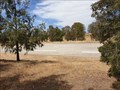 view gallery view gallerySW25.1 km |  Complexo Desportivo de Almodôvar - Almodôvar, Portugal Complexo Desportivo de Almodôvar - Almodôvar, Portugal
in Helicopter Landing Pads A helipad in Almodôvar posted by: Torgut location: Beja, Portugal date approved: 06/30/2019 last visited: never |
 view gallery view galleryNW25.1 km | Castelo de Aljustrel e Igreja de Nossa Senhora do Castelo - Aljustrel, Portugal in Património Português (Portuguese Heritage) Aljustrel's Castle is located in the village of Aljustrel, in the Alentejo region, currently little more than a few parts left in ruins, and the Church of Nossa Senhora do Castelo. posted by: tmob location: Beja, Portugal date approved: 01/26/2012 last visited: never |
|