 view gallery view gallery SW4.7 km SW4.7 km
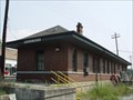
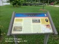
|   Eagle Rock Depot - Eagle Rock, Virginia Eagle Rock Depot - Eagle Rock, Virginia
in Train Stations/Depots This small train depot is located in the small town of Eagle Rock, Virginia posted by:  Sneakin Deacon Sneakin Deacon location: Virginia date approved: 09/11/2006 last visited: never |
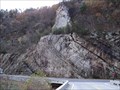 view gallery view gallerySW5 km |  EAGLE ROCK ANTICLINE & WATERGAP EAGLE ROCK ANTICLINE & WATERGAP
in Places of Geologic Significance A dramatic view of extreme folding and uplifting that can be viewed from U.S 220. Simply turn around to view a James River Watergap. posted by: woodhick803 location: Virginia date approved: 11/07/2010 last visited: never |
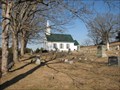 view gallery view gallery NW5 km NW5 km
|  Galatia Presbyterian Church - Gala, Va. Galatia Presbyterian Church - Gala, Va.
in Worldwide Cemeteries The Galatia Presbyterian Church Cemetery is located in Gala, Virginia posted by: Sneakin Deacon location: Virginia date approved: 03/01/2009 last visited: never |
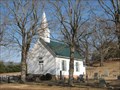 view gallery view galleryNW5 km |  Galatia Presbyterian Church - Gala, VA Galatia Presbyterian Church - Gala, VA
in Country Churches The Galatia Presbyterian Church is located in the Gala Community of Botetourt County, Virginia. posted by: Sneakin Deacon location: Virginia date approved: 03/02/2009 last visited: never |
 view gallery view gallery W6.8 km W6.8 km
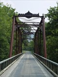
|  Phoenix Bridge Phoenix Bridge
in U.S. National Register of Historic Places The Phoenix Birdge is located at Craig's Creek in Botetourt County. posted by: Sneakin Deacon location: Virginia date approved: 09/11/2006 last visited: never |
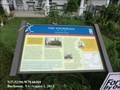
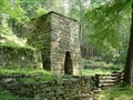 view gallery view galleryNW12.9 km | Roaring Run Furnace in U.S. National Register of Historic Places Roaring Run Furnace is located in the Jefferson National Forest and was operated in the mid-1800's. posted by: Sneakin Deacon location: Virginia date approved: 09/10/2006 last visited: 09/13/2008 |
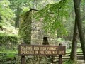 view gallery view galleryNW12.9 km |  Roaring Run Furnace Roaring Run Furnace
in Iron Furnace Ruins Roaring Run Furnace is located in the Jefferson National Forest and was operated in the mid-1800's. posted by: Sneakin Deacon location: Virginia date approved: 12/21/2006 last visited: 09/13/2008 |
 view gallery view gallery SE14 km SE14 km
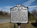
|  Audley Paul's Fort Audley Paul's Fort
in Virginia Historical Markers This historic markers detail the conflict between the Indians and settlers in the mid-1750's posted by: Sneakin Deacon location: Virginia date approved: 12/01/2006 last visited: 08/29/2022 |
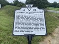 view gallery view gallerySE14.6 km | Cartmill's (Cartmell) Gap in Virginia Historical Markers A conflict during the Seven Years' War was nearby. posted by: Markerman62 location: Virginia date approved: 09/23/2022 last visited: never |
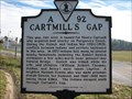 view gallery view gallerySE14.6 km | (Legacy) Cartmill's Gap in Virginia Historical Markers This historic marker details the conflicts between Indians and settlers in the mid-1700's posted by: Sneakin Deacon location: Virginia date approved: 12/01/2006 last visited: 09/24/2022 |
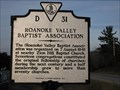 view gallery view gallerySW15.4 km | Roanoke Baptist Association in Virginia Historical Markers This historic marker is located in the median of U. S. Route 220 north of Fincastle, Virginia posted by: Sneakin Deacon location: Virginia date approved: 12/20/2006 last visited: never |
 view gallery view gallerySE16.4 km |  Buchanan Bridge An Artillery Duel Ensued - Buchanan VA Buchanan Bridge An Artillery Duel Ensued - Buchanan VA
in Civil War Discovery Trail Sites OnJune 14, 1864, after occupying Lexington and burning Virginia Military Institute, Union Gen. David Hunter’s 18,000-man force marched south through Buchanan, a river port located at the western terminus of the James River and Kanawha Canal. posted by:  Don.Morfe Don.Morfe location: Virginia date approved: 07/14/2020 last visited: 08/29/2022 |
 view gallery view gallerySE16.4 km | Buchanan Bridge-An Artillery Duel Ensued - Buchanan VA in U.S. Civil War Sites On June 14, 1864, after occupying Lexington and burning Virginia Military Institute, Union Gen. David Hunter’s 18,000-man force marched south toward Lynchburg through Buchanan. posted by: Don.Morfe location: Virginia date approved: 06/20/2023 last visited: 06/20/2023 |
 view gallery view gallerySE16.4 km |  Battle at Buchanan - Buchanan VA Battle at Buchanan - Buchanan VA
in Battlefields On June 14, 1864, after occupying Lexington and burning Virginia Military Institute, Union Gen. David Hunter’s 18,000-man force marched south toward Lynchburg through Buchanan, a river port located at the western terminus of the James River. posted by: Don.Morfe location: Virginia date approved: 11/08/2020 last visited: 10/17/2021 |
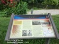
 view gallery view gallerySE16.4 km |  You Are Here Maps- Buchanan Bridge - Buchanan VA You Are Here Maps- Buchanan Bridge - Buchanan VA
in 'You Are Here' Maps The You Are Here map shows that you are in the parking lot near Twin River Outfitters at 635 Lowe Street, Buchanan VA 24066. posted by: Don.Morfe location: Virginia date approved: 07/13/2023 last visited: 07/13/2023 |
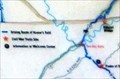
 view gallery view gallerySE16.4 km |  Buchanan & The James River & Kanawha Canal - Buchanan VA Buchanan & The James River & Kanawha Canal - Buchanan VA
in Signs of History Buchanan, Virginia is the western terminus of the James River & Kanawha Canal. Considered one of Virginia’s most remarkable engineering feats ever attempted. posted by: Don.Morfe location: Virginia date approved: 09/01/2020 last visited: 09/26/2021 |
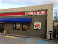 view gallery view gallerySE16.6 km |  Burger King #8657 - Main Street - Buchanan, Virginia Burger King #8657 - Main Street - Buchanan, Virginia
in Burger King Restaurants A BK Gas Station Hybrid located on West Main Street (US Route 11) in the Town of Buchanan, Botetourt County, Virginia. This location DOES NOT have a Drive-Thru Window. posted by: outdoorboy34 location: Virginia date approved: 02/23/2014 last visited: never |
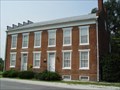 view gallery view gallerySE16.6 km | Wilson Warehouse in U.S. National Register of Historic Places The Wilson Warehouse or as it is known today The Community House is located near the banks of the James River in Buchanan, Virginia. posted by: Sneakin Deacon location: Virginia date approved: 09/11/2006 last visited: never |
 view gallery view gallerySE16.6 km | Wilson Warehouse “Fit only for … owls and bats.” - Buchanan VA in Civil War Discovery Trail Sites Federals swarmed through Buchanan and the surrounding countryside. They looted homes and farms for food and valuables. A resident wrote that the lower part of town was a ruin “fit only for the habitation of owls and bats.” posted by: Don.Morfe location: Virginia date approved: 07/14/2020 last visited: 08/29/2022 |
 view gallery view gallerySE16.6 km | Wilson Warehouse-“Fit only for … owls and bats.” - Buchanan VA in U.S. Civil War Sites On June 14, 1864, after Union Gen. David Hunter’s force forded the James River upstream from the Buchanan Bridge that Confederate John C. McCausland had partially burned, the Federals swarmed through Buchanan and the surrounding countryside. posted by: Don.Morfe location: Virginia date approved: 06/20/2023 last visited: 06/20/2023 |
 view gallery view gallerySE16.6 km | You Are Here Maps-Wilson Warehouse - Buchanan VA in 'You Are Here' Maps The You Are Here map shows that you are at the intersection of Lowe Street (County Road T-1305) and Washington Street
Buchanan, VA USA 24066 posted by: Don.Morfe location: Virginia date approved: 07/13/2023 last visited: 07/13/2023 |
 view gallery view gallerySE16.6 km | Wilson Warehouse “Fit only for … owls and bats.” - Buchanan VA in Battlefields Federals swarmed through Buchanan and the surrounding countryside. They looted homes and farms for food and valuables. A resident wrote that the lower part of town was a ruin “fit only for the habitation of owls and bats.” posted by: Don.Morfe location: Virginia date approved: 07/18/2023 last visited: 07/18/2023 |
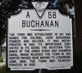 view gallery view gallerySE16.7 km | Buchanan in Virginia Historical Markers Buchanan was established in 1811 and named for Colonel John Buchanan. posted by: VirginiaSeeker location: Virginia date approved: 08/20/2006 last visited: 08/15/2021 |
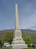 view gallery view gallerySE16.7 km | The Botetourt Artillery Monument, Buchanan, Virginia in American Civil War Monuments and Memorials Memorial Dedicated to the Men who enlisted in the Botetourt Artillery 1861-1865 posted by: Sneakin Deacon location: Virginia date approved: 04/21/2006 last visited: 08/19/2006 |
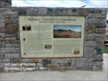
 view gallery view gallerySE16.9 km | The Anchorage - Buchanan VA in Battlefields Federals crossed the river at a ford south of The Anchorage on June 13. Averell’s men fired on the house, apparently believing that the civilians scrambling for shelter in the cellar were Confederate troops. posted by: Don.Morfe location: Virginia date approved: 07/18/2023 last visited: 07/18/2023 |
|