 view gallery view gallery N0 km N0 km
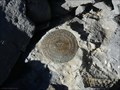
|   Grey Dome (HP0344) - Lincoln County, NV Grey Dome (HP0344) - Lincoln County, NV
in U.S. Benchmarks Triangulation station disk at the top of Grey Dome (AKA Sugarloaf). posted by:  valhikes valhikes location: Nevada date approved: 01/22/2024 last visited: 11/21/2023 |
 view gallery view gallery S6.8 km S6.8 km
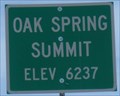
|  OAK SPRING SUMMIT 6237 - Nevada OAK SPRING SUMMIT 6237 - Nevada
in Elevation Signs A pass on U.S. 93 posted by:  nvtriker nvtriker location: Nevada date approved: 04/25/2009 last visited: 11/20/2023 |
 view gallery view gallery W9.2 km W9.2 km
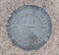
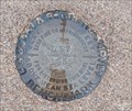
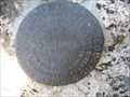
| K 57 (HP0078) - Lincoln County, NV in U.S. Benchmarks This benchmark disk is on the south side of U.S. 93 - in Lincoln County, Nevada. posted by: The Snowdog location: Nevada date approved: 01/03/2023 last visited: never |
 view gallery view galleryW11.6 km |  Delamar, The "Widow Maker" - Lincoln County, NV Delamar, The "Widow Maker" - Lincoln County, NV
in Nevada Historical Markers This Nevada Historical Marker is on the south side of the Great Basin Highway - in Lincoln County, Nevada. posted by: The Snowdog location: Nevada date approved: 01/01/2023 last visited: 11/20/2023 |
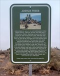 view gallery view galleryW11.6 km |  Joshua Trees - Lincoln County, NV Joshua Trees - Lincoln County, NV
in Flora and Fauna Information Signs This flora and fauna information sign is in a road side pull out that also hosts a Nevada Historical Marker - on the Great Basin Highway in Lincoln County, Nevada. posted by: The Snowdog location: Nevada date approved: 01/02/2023 last visited: 11/20/2023 |
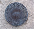
 view gallery view galleryW12.2 km | L 57 (HP0079)- Lincoln County, NV in U.S. Benchmarks This U.S. Coast and Geodetic Survey Benchmark Disk is on the north side of the Great Basin Highway - in Lincoln County, Nevada. posted by: The Snowdog location: Nevada date approved: 01/03/2023 last visited: never |
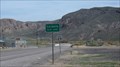
 view gallery view gallery E13.4 km E13.4 km
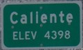
| Caliente 4398 - Nevada in Elevation Signs A town on U.S. 93 posted by: nvtriker location: Nevada date approved: 04/25/2009 last visited: 11/22/2023 |
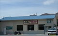 view gallery view galleryE14 km |  J and J Fast Food Restaurant - Caliente NV J and J Fast Food Restaurant - Caliente NV
in Independent Diners A local food joint. posted by: nvtriker location: Nevada date approved: 05/18/2009 last visited: 06/27/2011 |
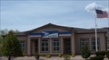 view gallery view galleryE14.2 km |  Caliente, NV 89008 Caliente, NV 89008
in U.S. Post Offices Caliente Nevada Post Office posted by: nvtriker location: Nevada date approved: 04/24/2009 last visited: 11/27/2011 |
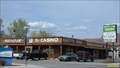 view gallery view galleryE14.2 km |  KNOTTY PINE Casino Caliente NV KNOTTY PINE Casino Caliente NV
in Casinos The only casino I know of in the area. posted by: nvtriker location: Nevada date approved: 05/13/2009 last visited: 09/10/2013 |
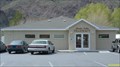 view gallery view galleryE14.3 km |  Meadow Valley Pharmacy - Caliente NV Meadow Valley Pharmacy - Caliente NV
in Independent Pharmacies A locally owned and operated pharmacy serving Lincoln county. posted by: nvtriker location: Nevada date approved: 04/25/2009 last visited: 09/10/2013 |
 view gallery view galleryE14.3 km |  Caliente, NV Caliente, NV
in Wikipedia Entries A historic railroad town in Lincoln County Nevada. posted by: nvtriker location: Nevada date approved: 04/25/2009 last visited: 03/26/2015 |
 view gallery view galleryE14.5 km | Q 2 (HP0088) - Caliente, NV in U.S. Benchmarks This benchmark disk is set in the wall at the entrance of the Caliente Community United Methodist Church - in Caliente, Nevada. posted by: The Snowdog location: Nevada date approved: 01/03/2023 last visited: never |
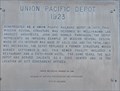 view gallery view galleryE14.5 km | Union Pacific Depot (1923) in Nevada Historical Markers Nevada State Historical Marker No. 249 is located at the east end of Union Pacific Depot in Caliente. The Depot is the largest structure for miles around. posted by: brwhiz location: Nevada date approved: 09/13/2012 last visited: never |
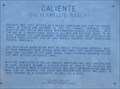 view gallery view galleryE14.5 km | Caliente (Culverwell's Ranch) in Nevada Historical Markers Nevada State Historical Marker No. 55 is located on the south side of US Highway 93 near the east end of Caliente. posted by: brwhiz location: Nevada date approved: 09/13/2012 last visited: 11/22/2023 |
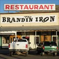 view gallery view galleryE14.6 km | Brandin' Iron - Caliente, NV in Independent Diners An independent dining establishment in Caliente, Nevada. posted by: nvtriker location: Nevada date approved: 05/18/2009 last visited: never |
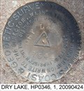 view gallery view galleryW15.8 km | DRY LAKE, Lincoln County NV in U.S. Benchmarks A triangulation station disk posted by: nvtriker location: Nevada date approved: 04/26/2009 last visited: never |
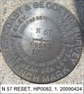 view gallery view galleryW18.3 km | N 57 RESET, Lincoln County NV in U.S. Benchmarks A standard benchmark disk posted by: nvtriker location: Nevada date approved: 04/26/2009 last visited: never |
 view gallery view gallery SW24.9 km SW24.9 km
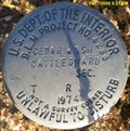
| CEDAR WASH CATTLEGUARD - Lincoln County, NV in U.S. Benchmarks A B.L.M. disk along a well maintained dirt road at a cattle guard. posted by: nvtriker location: Nevada date approved: 10/19/2009 last visited: never |
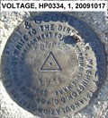 view gallery view gallerySW24.9 km | VOLTAGE, HP0334, - Lincoln County, NV in U.S. Benchmarks A triangulation station disk in the Delamar Valley. posted by: nvtriker location: Nevada date approved: 10/20/2009 last visited: never |
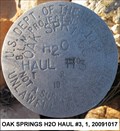 view gallery view gallerySW25.9 km | OAK SPRINGS H2O HAUL #3 - Lincoln County, NV in U.S. Benchmarks A BLM disk along a well maintained dirt road. posted by: nvtriker location: Nevada date approved: 10/20/2009 last visited: never |
 view gallery view gallery NE27.8 km NE27.8 km
| N 62 (HP0023) - Panaca, NV in U.S. Benchmarks U.S. Benchmark HP0023 (N 62) is on the south side of Highway 391 - in Panaca, Nevada. posted by: The Snowdog location: Nevada date approved: 01/03/2023 last visited: never |
 view gallery view gallery SE28 km SE28 km
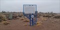
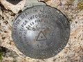
| HP0322 - Ella Mountain in U.S. Benchmarks A mark set in the bedrock atop Ella Mountain. Both azimuths found. posted by: ChapterhouseInc location: Nevada date approved: 08/11/2011 last visited: 07/24/2011 |
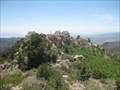 view gallery view gallerySE28 km |  Ella Mountain - BLM Ely District Ella Mountain - BLM Ely District
in Mountain Summits A mark set in the bedrock atop Ella Mountain notates the highest natural point. Only accessable when lookout is manned. posted by: ChapterhouseInc location: Nevada date approved: 08/12/2011 last visited: 10/20/2011 |
 view gallery view gallerySE28 km | Ella Mtn 2 - USCGS in U.S. Benchmarks One of two Reference Marks for the Ella Mountain Summit. posted by: ChapterhouseInc location: Nevada date approved: 08/24/2011 last visited: 07/24/2011 |
|