 view gallery view gallery SE0.2 km SE0.2 km
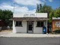
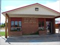
|   Henrieville, Utah 84736 Henrieville, Utah 84736
in U.S. Post Offices The Post Office serving Henrieville, Utah. posted by:  JacobBarlow JacobBarlow location: Utah date approved: 08/28/2007 last visited: 01/28/2016 |
 view gallery view gallery W5.3 km W5.3 km
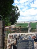
|  Grand Staircase Escalante - National Monument -- Canonville Visitors Center Grand Staircase Escalante - National Monument -- Canonville Visitors Center
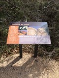
in NPS Passport Cancellation Stations The Grand Staircase-Escalante National Monument is one of the newest Monuments to be dedicated and an area of harsh desert environs and surreal beauty. The coordinates for this stamp station were taken outside the Visitors Center in Canonville, UT. posted by: Touchstone location: Utah date approved: 06/13/2006 last visited: 09/16/2013 |
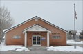 view gallery view galleryW5.3 km | Cannonville, Utah 84718 in U.S. Post Offices This Post Office is located at 25 S Redrock Drive in Cannonville, Utah. posted by: brwhiz location: Utah date approved: 12/25/2011 last visited: 07/01/2017 |
 view gallery view gallery NW8 km NW8 km
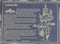
|  Loseeville ~ 477 Loseeville ~ 477
in D.U.P. Historic Markers This historical marker, erected by the Daughters of Utah Pioneers, is mounted on a stone monument at the site of the ghost town of Loseeville. posted by: brwhiz location: Utah date approved: 01/17/2014 last visited: never |
 view gallery view galleryNW8 km |  First Settlers of Loseeville First Settlers of Loseeville
in First of its Kind The first settlers of Loseeville were Ebenezer Bryce in 1876 and Daniel Goulding in 1878. posted by: brwhiz location: Utah date approved: 12/19/2013 last visited: never |
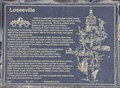 view gallery view galleryNW8 km | First Permanent Settlers in Loseeville in First of its Kind The first permanent settlers came to the Loseeville area in 1886. posted by: brwhiz location: Utah date approved: 12/19/2013 last visited: never |
 view gallery view galleryNW8 km |  Loseeville Loseeville
in Utah Historical Markers Clifton (Loseeville) was situated in East Valley one mile east of the Pahreah River and four miles North of Cannonville. The first settlers were Ebenezer Bryce in 1876 and Daniel Goulding in 1878.... posted by: JacobBarlow location: Utah date approved: 08/30/2007 last visited: 12/17/2013 |
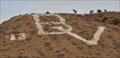 view gallery view galleryNW9 km |  BV for Bryce Valley BV for Bryce Valley
in Letters on Hills These Letters are the work of students at Bryce Valley High School in Tropic. posted by: brwhiz location: Utah date approved: 12/24/2013 last visited: 01/28/2016 |
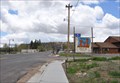
 view gallery view galleryNW10.3 km | Tropic, Utah 84776 in U.S. Post Offices The Post Office serving Tropic, Utah. posted by: JacobBarlow location: Utah date approved: 08/28/2007 last visited: 01/28/2016 |
 view gallery view galleryNW10.5 km |  Welcome to Tropic "Heart of Bryce Canyon" Welcome to Tropic "Heart of Bryce Canyon"
in Welcome Signs Welcome to Tropic "Heart of Bryce Canyon" posted by: JacobBarlow location: Utah date approved: 09/02/2007 last visited: 01/28/2016 |
 view gallery view galleryNW10.5 km |  Welcome to Tropic - Elev. 6,200 Welcome to Tropic - Elev. 6,200
in Elevation Signs The Welcome to Tropic Sign has a posted Elevation of 6,200 feet. posted by: JacobBarlow location: Utah date approved: 08/29/2007 last visited: 07/01/2017 |
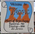 view gallery view galleryNW10.5 km |  Tropic, Utah ~ Population 460 Tropic, Utah ~ Population 460
in Population Signs This graphic Welcome Sign greets you at the northern town limits of Tropic. posted by: brwhiz location: Utah date approved: 06/15/2011 last visited: 07/01/2017 |
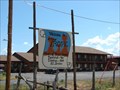
 view gallery view galleryNW10.5 km |  Welcome to Tropic, Utah Welcome to Tropic, Utah
in Artistic Welcome Signs This Welcome Sign greets you with a graphic of Bryce Canyon "Hoodoos". posted by: brwhiz location: Utah date approved: 06/18/2011 last visited: 01/28/2016 |
 view gallery view galleryNW10.5 km |  Tropic, Utah Tropic, Utah
in Wikipedia Entries Tropic is a small town of around 500 inhabitants on Utah Scenic Byway 12 directly east of Bryce Canyon National Park in southwest Garfield County. posted by: brwhiz location: Utah date approved: 06/15/2011 last visited: 01/28/2016 |
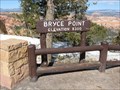
 view gallery view galleryW15 km |  Bryce Point Trailhead - Bryce Canyon Bryce Point Trailhead - Bryce Canyon
in Hiking and walking trailheads One of several overlooks that serve as trailheads. posted by: ChapterhouseInc location: Utah date approved: 08/28/2011 last visited: 09/15/2018 |
 view gallery view galleryW15 km | Bryce Point - 8300 feet - Bryce Canyon National Park, UT in Elevation Signs One of the many elevation signs at an overlook in Bryce Canyon National Park. posted by:  Rayman Rayman location: Utah date approved: 03/16/2009 last visited: 09/15/2018 |
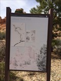
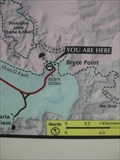 view gallery view galleryW15 km |  Bryce Point Map - Bryce Canyon Bryce Point Map - Bryce Canyon
in 'You Are Here' Maps A map showing your position in relation to the park points of interest. posted by: ChapterhouseInc location: Utah date approved: 08/24/2011 last visited: 11/16/2018 |
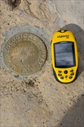 view gallery view galleryW15 km |  US Geological Survey Marker Bryce Canyon NP - UT US Geological Survey Marker Bryce Canyon NP - UT
in U.S. Benchmarks US Geological Survey Marker Bryce Canyon NP - UT posted by: kJfishman location: Utah date approved: 09/16/2010 last visited: 10/10/2012 |
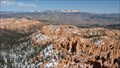 view gallery view galleryW15.1 km |  Bryce Point - Bryce Canyon National Park, UT Bryce Point - Bryce Canyon National Park, UT
in Scenic Overlooks Bryce Point provides arguably the best views of Bryce amphitheater. posted by: Rayman location: Utah date approved: 03/25/2009 last visited: 11/05/2023 |
 view gallery view galleryNW15.3 km | Building an Oasis - Bryce, UT in Utah Historical Markers A historical marker about the trail at Bryce Canyon National Park. posted by: bluesnote location: Utah date approved: 06/09/2018 last visited: 06/09/2018 |
 view gallery view galleryNW15.3 km |  Building an Oasis - Scenic Byway 12 - Bryce, UT Building an Oasis - Scenic Byway 12 - Bryce, UT
in National Scenic Byways A historical marker about the trail at Bryce Canyon National Park. posted by: bluesnote location: Utah date approved: 05/27/2018 last visited: 05/27/2018 |
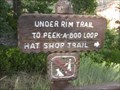
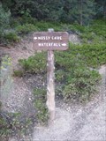 view gallery view galleryNW15.3 km | Mossy Cave Trail - Bryce Canyon in Scenic Hikes This short trail takes hikers to a small overhang and a waterfall. posted by: ChapterhouseInc location: Utah date approved: 08/31/2011 last visited: 05/05/2018 |
 view gallery view galleryNW15.3 km | Mossy Cave Trail - Bryce, UT in Utah Historical Markers A historical marker about the trail at Bryce Canyon National Park. posted by: bluesnote location: Utah date approved: 06/09/2018 last visited: 06/09/2018 |
 view gallery view galleryNW15.3 km | Mossy Cave Trail - Scenic Byway 12 - Bryce, UT in National Scenic Byways A historic trail along Scenic Byway 12 in Bryce Canyon National Park. posted by: bluesnote location: Utah date approved: 05/27/2018 last visited: 05/27/2018 |
 view gallery view galleryNW15.3 km | Mossy Cave Trail - Bryce, UT in Hiking and walking trailheads A historic trail along Scenic Byway 12 in Bryce Canyon National Park. posted by: bluesnote location: Utah date approved: 06/09/2018 last visited: 06/09/2018 |
|