 view gallery view gallery E10 km E10 km
|   AKRON (HF1285) - Cowley County, Kansas AKRON (HF1285) - Cowley County, Kansas
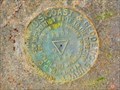
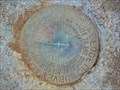
in U.S. Benchmarks A triangulation station located on the east side of US 77 about 5 miles south of Rock, Kansas. posted by:  Tom.dog Tom.dog location: Kansas date approved: 11/17/2022 last visited: never |
 view gallery view galleryE10.3 km | FORK 2 RM 4 (HF1504) - Cowley County, Kansas in U.S. Benchmarks Reference mark 4 for triangulation station FORK 2, located to the east of US 77. posted by: Tom.dog location: Kansas date approved: 11/06/2022 last visited: never |
 view gallery view galleryE10.3 km | FORK 2 (HF1502) - Cowley County, Kansas in U.S. Benchmarks A triangulation station located on the east side of US 77 about 2.25 miles south of Rock, Kansas. posted by: Tom.dog location: Kansas date approved: 11/06/2022 last visited: never |
 view gallery view galleryE10.3 km | FORK 2 RM 3 (HF1503) - Cowley County, Kansas in U.S. Benchmarks Reference mark 3 for triangulation station FORK 2, located on the south side of an abandoned paved road to the east of US 77 about 2.25 miles south of Rock, Kansas. posted by: Tom.dog location: Kansas date approved: 11/06/2022 last visited: never |
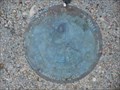
 view gallery view galleryE10.6 km | MILNUT RM 2 (HF0687) - Cowley County, Kansas in U.S. Benchmarks Reference mark 2 for triangulation station MILNUT. posted by: Tom.dog location: Kansas date approved: 11/17/2022 last visited: never |
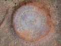
 view gallery view galleryE10.6 km | MILNUT (HF0688) - Cowley County, Kansas in U.S. Benchmarks A triangulation station at a decommissioned missile site south of Rock, Kansas. posted by: Tom.dog location: Kansas date approved: 11/17/2022 last visited: never |
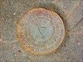
 view gallery view galleryE10.6 km | MILNUT RM 1 (HF0689) - Cowley County, Kansas in U.S. Benchmarks Reference mark 1 for triangulation station MILNUT. posted by: Tom.dog location: Kansas date approved: 11/17/2022 last visited: never |
 view gallery view gallery S11.6 km S11.6 km
|  Old Oxford Mill - Oxford, KS Old Oxford Mill - Oxford, KS
in U.S. National Register of Historic Places The Old Oxford Mill, constructed in 1874, is on the National Register of Historic Places - in Oxford, Kansas. posted by: The Snowdog location: Kansas date approved: 06/22/2021 last visited: never |
 view gallery view galleryS11.6 km |  Old Oxford Mill - Oxford, KS Old Oxford Mill - Oxford, KS
in Water Mills The Old Oxford Mill, constructed in 1874 by the Arkansas River, has been restored - in Oxford, Kansas. posted by: The Snowdog location: Kansas date approved: 06/22/2021 last visited: never |
 view gallery view galleryS11.6 km |  Old Oxford Mill - Oxford, KS Old Oxford Mill - Oxford, KS
in Official Local Tourism Attractions The Old Oxford Mill, constructed in 1874, has been restored - NE of Oxford, Kansas. posted by: The Snowdog location: Kansas date approved: 06/21/2021 last visited: never |
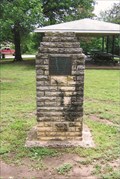
 view gallery view galleryS12.2 km |  Mount Vernon Cemetery - Cowley County, KS Mount Vernon Cemetery - Cowley County, KS
in Worldwide Cemeteries Mount Vernon Cemetery is about five miles northwest of Winfield - in Cowley County, Kansas. posted by: The Snowdog location: Kansas date approved: 09/17/2023 last visited: never |
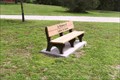 view gallery view galleryS13 km |  Leroy B. Korte ~ Oxford, KS Leroy B. Korte ~ Oxford, KS
in Dedicated Benches Old park, once popular with travelers when US highways were popular. posted by: YoSam. location: Kansas date approved: 10/02/2010 last visited: never |
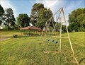 view gallery view galleryS13 km |  Cave Park - Oxford, KS Cave Park - Oxford, KS
in Public Playgrounds Cave Park is on both sides of Highway 160, just west of the Arkansas River - in Oxford, Kansas. posted by: The Snowdog location: Kansas date approved: 06/21/2021 last visited: never |
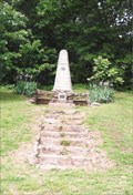
 view gallery view galleryS13 km |  Dr. Fred C. Cave Cairn - Oxford, KS Dr. Fred C. Cave Cairn - Oxford, KS
in Cairns Not much info on this guy, but he must have been something once. Cairn is in this park named after him. posted by: YoSam. location: Kansas date approved: 02/18/2023 last visited: never |
 view gallery view galleryS13 km |  Dr. Fred C. Cave - Oxford, KS Dr. Fred C. Cave - Oxford, KS
in Citizen Memorials Not much info on this guy, but he must have been something once. posted by: YoSam. location: Kansas date approved: 01/31/2017 last visited: never |
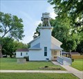 view gallery view galleryS13 km |  First Presbyterian Church - Oxford, KS First Presbyterian Church - Oxford, KS
in This Old Church The First Presbyterian Church was constructed in 1873 - in Oxford, Kansas. posted by: The Snowdog location: Kansas date approved: 06/21/2021 last visited: never |
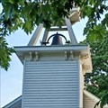 view gallery view galleryS13 km |  First Presbyterian Church Bell Tower - Oxford, KS First Presbyterian Church Bell Tower - Oxford, KS
in Bell Towers The tower on the First Presbyterian Church houses a single large bell - in Oxford, Kansas. posted by: The Snowdog location: Kansas date approved: 06/21/2021 last visited: never |
 view gallery view galleryS13.2 km |  Cave Park - Oxford, KS Cave Park - Oxford, KS
in Municipal Parks and Plazas Neat city park. started WPA project, and has free camping posted by: YoSam. location: Kansas date approved: 01/31/2017 last visited: 06/19/2021 |
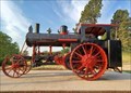 view gallery view galleryS13.2 km |  1916 Avery 2-Cylinder Steam Tractor - Oxford, KS 1916 Avery 2-Cylinder Steam Tractor - Oxford, KS
in Old Tractors This beautifully restored 1916 Avery steam tractor is on display at Cave Park, on the east side of Oxford, Kansas. posted by: The Snowdog location: Kansas date approved: 06/21/2021 last visited: never |
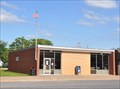 view gallery view galleryS13.2 km |  Oxford, Kansas 67119 Oxford, Kansas 67119
in U.S. Post Offices This Post Office is located at 120 N Sumner Street in Oxford, Kansas. posted by: brwhiz location: Kansas date approved: 09/02/2012 last visited: never |
 view gallery view gallery SW13.7 km SW13.7 km
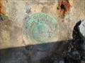
| K 336 (HF0616) - Sumner County, Kansas in U.S. Benchmarks A benchmark to the south of US 160, about 0.7 miles west of the Oxford town center. posted by: Tom.dog location: Kansas date approved: 11/16/2022 last visited: never |
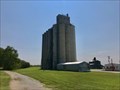 view gallery view galleryS13.8 km | OXFORD PARITY MILLS ELEVATOR (HF1290) - Sumner County, Kansas in U.S. Benchmarks An intersection station observed atop Oxford's one-and-only "skyscraper of the plains." posted by: Tom.dog location: Kansas date approved: 07/31/2023 last visited: never |
 view gallery view gallery W14.2 km W14.2 km
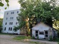
|  Abandoned Concrete Grain Elevator Abandoned Concrete Grain Elevator
in Grain Elevators This abandoned Grain Elevator is located behind the self-storage building at 437 N Washington Street in Belle Plaine, Kansas. posted by: brwhiz location: Kansas date approved: 02/08/2013 last visited: 05/02/2015 |
 view gallery view gallery N14.3 km N14.3 km
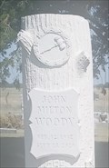
|  Auctioneer - John Milton Woody - Richland Cemetery, Butler County, KS Auctioneer - John Milton Woody - Richland Cemetery, Butler County, KS
in Occupational/Hobby Grave Stones A gavel indicates that John Milton Woody was a auctioneer - interred in Richland Cemetery, Butler County, Kansas. posted by: The Snowdog location: Kansas date approved: 09/06/2023 last visited: never |
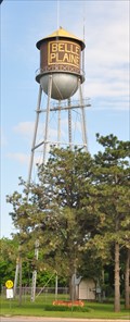 view gallery view galleryW14.3 km | HF1348 ~ BELLE PLAINE MUNICIPAL TANK in U.S. Benchmarks This survey mark is the top center of the water tower located on the south side of 4th Avenue, about halfway between Main and Lincoln Streets, in Belle Plaine, Kansas. posted by: brwhiz location: Kansas date approved: 02/21/2013 last visited: never |
|