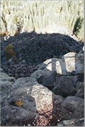
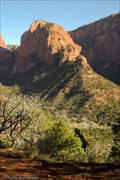
 view gallery view gallery NW9.7 km NW9.7 km
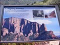
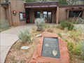
|   Collapsing Scenery-Kolob Canyons-Zion National Park - New Harmony UT Collapsing Scenery-Kolob Canyons-Zion National Park - New Harmony UT
in Utah Historical Markers Marker is located at the Kolob Canyons Viewpoint in New Harmony, Utah, in Washington County 84757. posted by:  Don.Morfe Don.Morfe location: Utah date approved: 11/17/2023 last visited: 11/17/2023 |
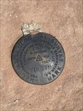
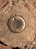 view gallery view galleryNW9.7 km |  Radius Point 45 FT - Washington County, UT Radius Point 45 FT - Washington County, UT
in U.S. Benchmarks A disc in concrete. posted by:  bergmannfamily bergmannfamily location: Utah date approved: 09/23/2022 last visited: never |
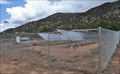
 view gallery view gallery N10.9 km N10.9 km
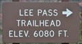
|  Lee Pass Trailhead (South End) ~ Elevation 6080 feet Lee Pass Trailhead (South End) ~ Elevation 6080 feet
in Elevation Signs This Elevation Sign is at the south end of the parking area for the Lee Pass Trailhead in the Kolob Canyons section of Zion National Park. posted by: brwhiz location: Utah date approved: 09/12/2013 last visited: never |
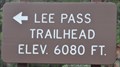 view gallery view galleryN10.9 km | Lee Pass Trailhead (North End) ~ Elevation 6080 feet in Elevation Signs This Elevation Sign is at the north end of the parking area for the Lee Pass Trailhead in the Kolob Canyons section of Zion National Park. posted by: brwhiz location: Utah date approved: 09/12/2013 last visited: never |
 view gallery view gallery E11.1 km E11.1 km
|  Zion National Park - Lava Point Zion National Park - Lava Point
in National Parks of the World These coordinates take you to a basalt flow within Zion National Park. The dirt road from Kolob Road to Lava Point is an easy drive for all but lowered vehicles. However, it is closed during the winter. posted by: TerryDad2 location: Utah date approved: 08/24/2006 last visited: 04/30/2007 |
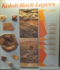 view gallery view galleryNW12.4 km |  Kolob Rock Layers Kolob Rock Layers
in Rock and Mineral Displays This display graphically the rock layers that make up the Kolob Canyons area of Zion National park. posted by: brwhiz location: Utah date approved: 04/02/2012 last visited: 08/05/2014 |
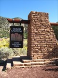
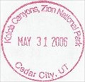 view gallery view galleryNW12.6 km |  Kolob Canyons, Zion National Park - Cedar City, UT -- Visitors Center Kolob Canyons, Zion National Park - Cedar City, UT -- Visitors Center
in NPS Passport Cancellation Stations A small subsection of Zion National Park located 2 miles off of I-15 posted by: gparkes location: Utah date approved: 12/09/2008 last visited: 11/17/2023 |
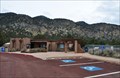 view gallery view galleryNW12.6 km |  Kolob Canyons Visitor Center ~ Zion National Park Kolob Canyons Visitor Center ~ Zion National Park
in Ranger Stations This National Park Service Ranger Station and Visitor Center is at the access to the Kolob Canyons portion of Zion National Park. posted by: brwhiz location: Utah date approved: 04/02/2012 last visited: 11/17/2023 |
 view gallery view galleryNW12.6 km | Zion National Park - Kolob Canyon - Springdale, Utah in National Parks of the World The higher elevation Kolob Canyon portion of Zion National Park is less visited than the lower canyon, but it has its own wealth of treasures, including a 5-mile scenic drive with numerous scenic pull-outs. posted by: DopeyDuck location: Utah date approved: 04/21/2010 last visited: 11/17/2023 |
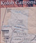
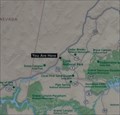 view gallery view galleryNW12.6 km |  Parks of the Grand Circle Parks of the Grand Circle
in 'You Are Here' Maps You Are Here outside the Kolob Canyons Visitor Center at the map of the National Parks that comprise the Grand Circle. posted by: brwhiz location: Utah date approved: 04/02/2012 last visited: 08/05/2014 |
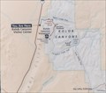 view gallery view galleryNW12.6 km | Zion National Park in 'You Are Here' Maps You Are Here outside the Kolob Canyons Visitor Center at the map of the entirety of Zion National Park. posted by: brwhiz location: Utah date approved: 04/02/2012 last visited: 05/12/2023 |
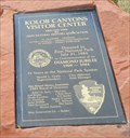 view gallery view galleryNW12.6 km |  Zion National Park - 75 Years - New Harmony, Utah Zion National Park - 75 Years - New Harmony, Utah
in Commercial Commemorations This plaque, celebrating the construction of the Kolob Visitor Center, honors the 75th anniversary of Zion National Park. The plaque is set into a large red rock in front of the Visitor Center. posted by: iconions location: Utah date approved: 09/07/2019 last visited: never |
 view gallery view galleryNW12.6 km |  Kolob Canyons Visitor Center - 1984 - Zion National Park, Utah Kolob Canyons Visitor Center - 1984 - Zion National Park, Utah
in Dated Architectural Structures Multifarious This Visitor's Center, located off exit 40 on I-15, is the unit of Zion National Park furthest west and North from the main part of the Park. posted by: iconions location: Utah date approved: 09/08/2019 last visited: 11/17/2023 |
 view gallery view galleryNW12.6 km |  Kolob Canyons Visitor Center Solar Array Kolob Canyons Visitor Center Solar Array
in Solar Power This Photovoltaic Array is at the Kolob Canyons Visitor Center on the northeast corner of Zion National Park. posted by: brwhiz location: Utah date approved: 09/08/2013 last visited: 09/02/2019 |
 view gallery view galleryNW12.6 km | Kolob Canyons "You Are Here" - Zion NP, Utah in 'You Are Here' Maps There are three different "You Are Here" signs outside the Kolob Canyons Visitor Center. posted by: nvtriker location: Nevada date approved: 05/20/2009 last visited: 09/02/2019 |
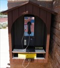 view gallery view galleryNW12.6 km |  Payphone - Kolob Canyons Visitor Center - Cedar City, UT Payphone - Kolob Canyons Visitor Center - Cedar City, UT
in Payphones Payphone at the Kolob Canyons Visitor Center near Cedar City, Utah. posted by: nvtriker location: Nevada date approved: 05/21/2009 last visited: 09/11/2016 |
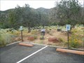 view gallery view galleryNW12.6 km |  Kolob Canyons Charging Station - New Harmony, Utah Kolob Canyons Charging Station - New Harmony, Utah
in Electric Car Charging Stations This two bay charging station is located to the left of the Kolob Canyons Visitor's Center - Exit 40, I-15 near New Harmony, Utah. posted by: iconions location: Utah date approved: 09/06/2019 last visited: never |
 view gallery view galleryNW12.6 km | ") Kolob Canyons area - Zion NP, Utah Kolob Canyons area - Zion NP, Utah
in National Parks (U.S.) Just 2 miles off the I-15 you will find the Kolob Canyons region of Zion National Park. This quiet and scenic area features red cliffs and narrow canyons and is far from the sometimes maddening crowds that affect the main valley 20 miles to the SE. posted by: GeoKs location: Utah date approved: 10/22/2007 last visited: 11/17/2023 |
 view gallery view gallery S12.9 km S12.9 km
| Virgin - Wasnington County, UT in U.S. Benchmarks Unlisted benchmark at southern most end of Smith Mesa overlooking Hurricane Mesa and the town of Virgin, Utah. posted by: mojave_rattler location: Utah date approved: 07/28/2023 last visited: never |
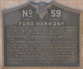 view gallery view galleryNW15.9 km | Fort Harmony in Utah Historical Markers The historic Fort Harmony site is just west of Interstate 15 at the New Harmony exit. posted by: brwhiz location: Utah date approved: 04/05/2012 last visited: 09/01/2013 |
 view gallery view gallery SW16.6 km SW16.6 km
|  Toquerville, Utah Toquerville, Utah
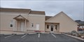
in City and Town Halls This Town Hall is located at 212 N Toquer Blvd in Toquerville, Utah. posted by: brwhiz location: Utah date approved: 04/08/2013 last visited: never |
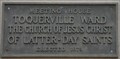 view gallery view gallerySW16.6 km | Toquerville Ward Meeting House in Utah Historical Markers This Historical Marker is mounted on the front of the historic Toquerville LDS Meetinghouse at 206 N Toquer Blvd in Toquerville, Utah. posted by: brwhiz location: Utah date approved: 04/08/2013 last visited: 05/25/2014 |
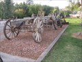 view gallery view gallerySW16.6 km |  Buckboard Wagon, Toquerville, Utah Buckboard Wagon, Toquerville, Utah
in Old Agricultural Equipment This neat old equipment is on display in Toquerville, Utah. posted by: Queens Blessing location: Utah date approved: 12/04/2012 last visited: 06/02/2016 |
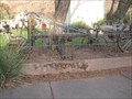 view gallery view gallerySW16.6 km | Roadgrade, Toquerville, Utah in Old Agricultural Equipment This old equipment is on display in Toquerville. posted by: Queens Blessing location: Utah date approved: 12/04/2012 last visited: 06/02/2016 |
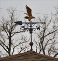 view gallery view gallerySW16.6 km |  Toquerville Meetinghouse Eagle Weathervane Toquerville Meetinghouse Eagle Weathervane
in Unique Weathervanes This Weathervane is mounted on top of the pavilion in front of the historic Toquerville LDS Meetinghouse at 206 N Toquer Blvd in Toquerville, Utah. posted by: brwhiz location: Utah date approved: 04/08/2013 last visited: 05/25/2014 |
|