 view gallery view gallery N0 km N0 km
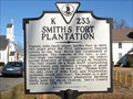
|   Smith's Fort Plantation Smith's Fort Plantation
in Virginia Historical Markers Smith's Fort was on the opposite side of the James River from Jamestown. posted by:  VirginiaSeeker VirginiaSeeker location: Virginia date approved: 01/28/2007 last visited: 03/21/2013 |
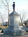 view gallery view galleryN0.2 km |  Confederate Soldier Memorial of Surry County Confederate Soldier Memorial of Surry County
in American Civil War Monuments and Memorials A granite and Bronze Memorial to Confederate Soldiers from Surry County, Virginia posted by:  AZkayaker AZkayaker location: Virginia date approved: 02/14/2009 last visited: 03/21/2013 |
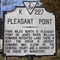 view gallery view gallery E2.7 km E2.7 km
| Pleasant Point in Virginia Historical Markers Pleasant Point is located on the James River. posted by: VirginiaSeeker location: Virginia date approved: 01/29/2007 last visited: never |
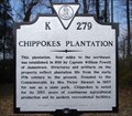 view gallery view galleryE2.7 km | Chippokes Plantation in Virginia Historical Markers Chippokes Plantation is now a state park dedicated to depicting life during the colonial period. posted by: VirginiaSeeker location: Virginia date approved: 01/29/2007 last visited: 11/20/2010 |
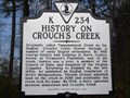 view gallery view galleryE2.7 km | History on Crouch's Creek in Virginia Historical Markers Crouch's Creek was originally called Tappahannock Creek. posted by: VirginiaSeeker location: Virginia date approved: 01/29/2007 last visited: never |
 view gallery view gallery W4.5 km W4.5 km
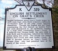
| English Settlement on Gray's Creek in Virginia Historical Markers Early settlements were part of the defense of Jamestown across the river. posted by: VirginiaSeeker location: Virginia date approved: 01/30/2007 last visited: never |
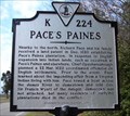 view gallery view galleryW4.5 km | Pace's Paines in Virginia Historical Markers Richard Pace rowed across the James River to Jamestown to warn of a possible attack. posted by: VirginiaSeeker location: Virginia date approved: 01/30/2007 last visited: never |
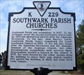 view gallery view galleryW4.5 km | Southwark Parish Churches in Virginia Historical Markers Southwark Parish was a colonial church in Surry County. posted by: VirginiaSeeker location: Virginia date approved: 01/30/2007 last visited: 05/09/2009 |
 view gallery view gallery NE7.1 km NE7.1 km
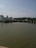
|  Jamestown-Scotland Ferry - Scotland, VA Jamestown-Scotland Ferry - Scotland, VA
in Ferries and Ferry Landings The Virginia Department of Transportation runs a ferry from Jamestown, in James City County, to Scotland, in Surry County, across the James River. They have four ferries and provide a free ride across the river. posted by: xptwo location: Virginia date approved: 09/01/2012 last visited: 03/29/2024 |
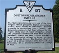 view gallery view galleryE8.4 km | Quiyoughcohannock Indians in Virginia Historical Markers The Quiyoughcohannock were one of the first Virginia Indians the English settlers encountered. posted by: VirginiaSeeker location: Virginia date approved: 09/10/2006 last visited: never |
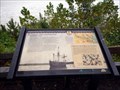
 view gallery view galleryE8.7 km |  Working the Land Captain John Smith Chesapeake National Historic Trail - Surry, VA Working the Land Captain John Smith Chesapeake National Historic Trail - Surry, VA
in Signs of History Indians cultivated fertile lands along the James River for centuries before the colonists arrived in 1607. They grew squash, corn, and beans to supplement their diet of native plants, fish, shellfish, and game. posted by: Don.Morfe location: Virginia date approved: 01/22/2020 last visited: 09/25/2021 |
 view gallery view galleryE8.7 km | Captain John Smith’s Adventures on the James -Surry, VA in Signs of History Captain John Smith’s Adventures on the James-Chippokes Plantation State Park— James River beach —Prior to unloading at Jamestown, the English sailed the James in search of a suitable location. In his account, George Perch recalls crossing to the southern shore on May 5, 1607 at the invitation of a chief he misidentifies as the "Werowance of Rapahanna." posted by: Don.Morfe location: Virginia date approved: 01/22/2020 last visited: 09/25/2021 |
 view gallery view galleryE8.7 km |  Working the Land Captain John Smith Chesapeake National Historic Trail - Surry, VA Working the Land Captain John Smith Chesapeake National Historic Trail - Surry, VA
in Civil Rights Memorials Indians cultivated fertile lands along the James River for centuries before the colonists arrived in 1607. They grew squash, corn, and beans to supplement their diet of native plants, fish, shellfish, and game. posted by: Don.Morfe location: Virginia date approved: 09/27/2023 last visited: 09/27/2023 |
 view gallery view galleryE8.7 km |  Chippokes State Park - Surry VA Chippokes State Park - Surry VA
in Wikipedia Entries Chippokes State Park (previously known as Chippokes Plantation State Park) is located at 695 Chippokes Park Road, Surry VA 23883 posted by: Don.Morfe location: Virginia date approved: 09/26/2023 last visited: 09/26/2023 |
 view gallery view galleryE8.7 km |  Chippokes State Park - Surry VA Chippokes State Park - Surry VA
in Official Local Tourism Attractions Chippokes State Park (previously known as Chippokes Plantation State Park) is located at 695 Chippokes Park Road, Surry VA 23883 posted by: Don.Morfe location: Virginia date approved: 09/26/2023 last visited: 09/26/2023 |
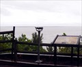 view gallery view galleryE8.7 km |  Coin-Operated Binoculars at Chippokes State Park - Surry VA Coin-Operated Binoculars at Chippokes State Park - Surry VA
in Coin-Op Binoculars The Coin-Operated Binocular at Chippokes State Park is at the water's edge. Chippokes State Park (previously known as Chippokes Plantation State Park) is located at 695 Chippokes Park Road, Surry VA 23883 posted by: Don.Morfe location: Virginia date approved: 09/27/2023 last visited: 09/27/2023 |
 view gallery view galleryE8.7 km |  Chippokes State Park - Surry VA Chippokes State Park - Surry VA
in State/Provincial Parks Chippokes State Park (previously known as Chippokes Plantation State Park) is located at 695 Chippokes Park Road, Surry VA 23883 posted by: Don.Morfe location: Virginia date approved: 09/27/2023 last visited: 09/27/2023 |
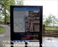
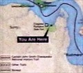 view gallery view galleryE8.7 km |  'You Are Here' Maps-Chippokes State Park - Surry VA 'You Are Here' Maps-Chippokes State Park - Surry VA
in 'You Are Here' Maps The 'You Are Here' Map shows that you are at Chippokes State Park (previously known as Chippokes Plantation State Park) is located at 695 Chippokes Park Road, Surry VA 23883 posted by: Don.Morfe location: Virginia date approved: 09/26/2023 last visited: 09/26/2023 |
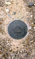
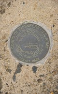
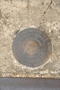 view gallery view galleryNE9.5 km |  COE 2+00 - Jamestown, VA COE 2+00 - Jamestown, VA
in U.S. Benchmarks Corps of Engineers survey mark set in 1997 at the top of a concrete seawall on the grounds of the Jamestown settlement. posted by: Ernmark location: Virginia date approved: 10/05/2013 last visited: 03/27/2015 |
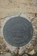
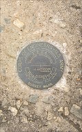 view gallery view galleryNE9.5 km | COE 1+24 - Jamestown, VA in U.S. Benchmarks Corps of Engineers survey mark set in 1997 at the top of a concrete seawall on the grounds of the Jamestown settlement. posted by: Ernmark location: Virginia date approved: 10/05/2013 last visited: 03/28/2015 |
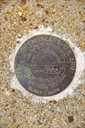
 view gallery view galleryNE9.5 km | COE 4+00 - Jamestown, VA in U.S. Benchmarks Corps of Engineers survey mark set in 1997 at the top of a concrete seawall on the grounds of the Jamestown settlement. posted by: Ernmark location: Virginia date approved: 10/05/2013 last visited: 03/27/2015 |
 view gallery view galleryNE9.5 km | COE 4+23 - Jamestown, VA in U.S. Benchmarks Corps of Engineers survey mark set in 1997 at the top of a concrete seawall on the grounds of the Jamestown settlement. posted by: Ernmark location: Virginia date approved: 10/05/2013 last visited: 03/28/2015 |
 view gallery view galleryNE9.5 km | COE 0+00 - Jamestown, VA in U.S. Benchmarks Corps of Engineers survey mark set in 1997 at the top of a concrete seawall on the grounds of the Jamestown settlement. posted by: Ernmark location: Virginia date approved: 10/06/2013 last visited: 03/28/2015 |
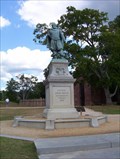 view gallery view galleryNE9.5 km |  Captain John Smith Captain John Smith
in Statues of Historic Figures Captain John Smith, Govenor of Virginia -1608 posted by: AZkayaker location: Virginia date approved: 08/13/2006 last visited: 04/18/2024 |
 view gallery view galleryNE9.5 km | COE 6+00 - Jamestown, VA in U.S. Benchmarks Corps of Engineers survey mark set in 1997 at the top of a concrete seawall on the grounds of the Jamestown settlement. posted by: Ernmark location: Virginia date approved: 10/05/2013 last visited: 03/27/2015 |
|