 view gallery view gallery E0 km E0 km
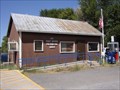
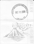
|   Folsom, NM 88419 Folsom, NM 88419
in U.S. Post Offices Located at: 53 Grand Ave Folsom, NM 88419 (575) 278-2150. Elevation: 6,400 feet above sea level. First appointed postmaster was Fairchild Drew on April 12,1883. posted by:  beagle39z beagle39z location: New Mexico date approved: 09/11/2009 last visited: never |
 view gallery view gallery SW8 km SW8 km
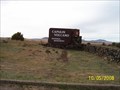
| ") Capulin Volcano National Monument Capulin Volcano National Monument
in National Parks (U.S.) Capulin Volcano National Monument, located in Northeastern New Mexico, was designated a U.S. National Monument on August 9, 1916. posted by:  Web-ling Web-ling location: New Mexico date approved: 10/30/2006 last visited: 01/15/2023 |
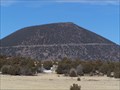
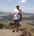 view gallery view gallerySW8 km |  Capulin Volcano Capulin Volcano
in Mountain Summits An extinct volcano in NE New Mexico posted by: Web-ling location: New Mexico date approved: 10/30/2006 last visited: 01/15/2023 |
 view gallery view gallerySW8.4 km |  Capulin Volcano - nr Capulin, NM Capulin Volcano - nr Capulin, NM
in Volcano Watching Capulin Volcano is one of many extinct volcanoes in this part of northern New Mexico. posted by: Benchmark Blasterz location: New Mexico date approved: 10/14/2014 last visited: 01/15/2023 |
 view gallery view gallerySW8.4 km |  Capulin Volcano National Monument Capulin Volcano National Monument
in Wikipedia Entries Capulin Volcano erupted into existence sometime between 56,000 and 62,000 years ago. posted by: mr.volkswagen location: New Mexico date approved: 01/11/2009 last visited: 01/15/2023 |
 view gallery view gallerySW8.4 km |  Capulin Volcano National Monument - Capulin NM Capulin Volcano National Monument - Capulin NM
in National Parks of the World Capulin Volcano National Monument is a U.S. National Monument located in northeastern New Mexico that protects and interprets an extinct cinder cone volcano and is part of the Raton-Clayton volcanic field. posted by:  Don.Morfe Don.Morfe location: New Mexico date approved: 01/15/2023 last visited: 01/15/2023 |
 view gallery view gallerySW8.4 km |  Capulin Volcano National Monument - Capulin NM Capulin Volcano National Monument - Capulin NM
in Official Local Tourism Attractions Capulin Volcano National Monument is an example of an extinct cinder cone volcano, & part of the Raton-Clayton Volcanic Field. A paved road spirals around the volcano and visitors can drive up to a parking lot at the rim. posted by: Don.Morfe location: New Mexico date approved: 01/14/2023 last visited: 01/15/2023 |
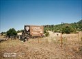
 view gallery view gallerySW8.4 km |  Ranger Station at Capulin Volcano National Monument - Capulin NM Ranger Station at Capulin Volcano National Monument - Capulin NM
in Ranger Stations The Ranger Station is inside the Visitor Center at Capulin Volcano National Monument. Here one may obtain a NPS Cancellation Stamp. posted by: Don.Morfe location: New Mexico date approved: 01/17/2023 last visited: 01/15/2023 |
 view gallery view gallerySW8.4 km |  Capulin Volcano National Monument - Capulin NM Capulin Volcano National Monument - Capulin NM
in Satellite Imagery Oddities Capulin Volcano National Monument is an example of an extinct cinder cone volcano, & part of the Raton-Clayton Volcanic Field. A paved road spirals around the volcano and visitors can drive up to a parking lot at the rim. posted by: Don.Morfe location: New Mexico date approved: 01/14/2023 last visited: 01/15/2023 |
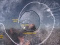 view gallery view gallerySW8.4 km |  INSIDE Capulin Volcano, New Mexico INSIDE Capulin Volcano, New Mexico
in 'You Are Here' Maps If this sign is in front of you, you are INSIDE the Capulin volcano! posted by: Queens Blessing location: New Mexico date approved: 06/13/2010 last visited: 03/19/2011 |
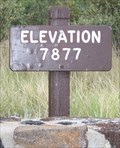 view gallery view gallerySW8.4 km |  Capulin Volcano, NM (7,877 ft) Capulin Volcano, NM (7,877 ft)
in Elevation Signs Located in the Capulin Volcano National Monument. posted by: mr.volkswagen location: New Mexico date approved: 07/23/2008 last visited: 07/23/2007 |
 view gallery view gallerySW9.2 km |  Capulin Volcano Cancellation Station - Capulin, NM Capulin Volcano Cancellation Station - Capulin, NM
in NPS Passport Cancellation Stations Located at the Vistitor center at the base of the volcano. posted by: mr.volkswagen location: New Mexico date approved: 01/21/2009 last visited: 01/15/2023 |
 view gallery view gallerySW12.2 km | You Are at Capulin Volcano, New Mexico in 'You Are Here' Maps Capulin Volcano can be seen in the distance from this sign that indicates you are at the volcano. posted by: Queens Blessing location: New Mexico date approved: 06/13/2010 last visited: 07/23/2007 |
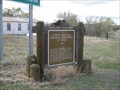
 view gallery view gallerySW12.2 km |  Capulin Volcano National Monument Capulin Volcano National Monument
in New Mexico Historical Markers There are several of these signs along the route to Capulin Volcano. posted by: Queens Blessing location: New Mexico date approved: 06/14/2010 last visited: 07/23/2007 |
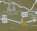
 view gallery view gallerySW13.2 km | Capulin Volcano National Monument, New Mexico in New Mexico Historical Markers This sign is located at the intersection of highways 87 & 325 in the tiny town of Capulin, New Mexico. posted by: Queens Blessing location: New Mexico date approved: 06/13/2010 last visited: 07/23/2007 |
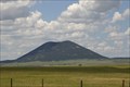
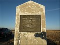
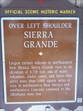 view gallery view gallery SE21.4 km SE21.4 km
| Sierra Grande in New Mexico Historical Markers Located on Hwy. 85/64 between Clayton and Raton posted by: mr.volkswagen location: New Mexico date approved: 12/23/2008 last visited: 07/23/2007 |
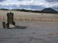
 view gallery view gallerySE21.4 km |  Hwy. 85/64 Rest Area - Union County, New Mexico Hwy. 85/64 Rest Area - Union County, New Mexico
in Highway Rest Areas Located Between Clayton and Raton. posted by: mr.volkswagen location: New Mexico date approved: 12/23/2008 last visited: 07/23/2007 |
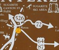
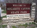 view gallery view gallery W42.3 km W42.3 km
|  Sugarite Canyon State Park - Raton, NM Sugarite Canyon State Park - Raton, NM
in State/Provincial Parks Located on the New Mexico/Colorado border, Sugarite Canyon State Park features heavily wooded mountains and meadows painted with wildflowers and butterflies. posted by: beagle39z location: New Mexico date approved: 05/05/2009 last visited: 10/03/2017 |
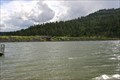 view gallery view galleryW43.6 km |  Lake Maloya Dam -- Sugarite Cyn SP, nr Raton NM Lake Maloya Dam -- Sugarite Cyn SP, nr Raton NM
in Water Dams An earthen dam across Sugarite Creek creates Lake Maloya in beautiful Sugarite Canyon State park near Raton NM posted by: Benchmark Blasterz location: New Mexico date approved: 10/13/2014 last visited: 10/14/2014 |
 view gallery view gallerySE44.1 km |  Santa Fe Trail – Cimarron Cutoff – Grenville, New Mexico Santa Fe Trail – Cimarron Cutoff – Grenville, New Mexico
in Wagon Roads and Trails This roadside marker located just South and East of the town of Grenville, New Mexico, marks the first use of wagons on the Santa-Fe trail. The use of wagons instead of pack animals dramatically expanded migration and trade in the region. posted by: PersonsMD location: New Mexico date approved: 01/08/2013 last visited: 12/08/2012 |
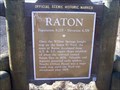 view gallery view galleryW44.7 km | Raton in New Mexico Historical Markers Located on the East side of Raton as you are heading toward Clayton. On the North side of the highway. posted by: mr.volkswagen location: New Mexico date approved: 01/08/2009 last visited: 07/24/2007 |
 view gallery view galleryW44.7 km | Raton, NM (6,379 ft.) in Elevation Signs Located east of Raton on Highway 87/64 on the North side of the highway. posted by: mr.volkswagen location: New Mexico date approved: 01/12/2009 last visited: 07/24/2007 |
 view gallery view galleryW44.7 km | You Are Here in Raton, New Mexico in 'You Are Here' Maps This sign is on the reverse side of a New Mexico State historical sign. posted by: Queens Blessing location: New Mexico date approved: 06/13/2010 last visited: 07/24/2007 |
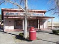
 view gallery view galleryW45.9 km |  DQ - Raton, NM DQ - Raton, NM
in Dairy Queen Restaurants Cross Streets: Between Clayton Rd and Waite St
posted by: beagle39z location: New Mexico date approved: 05/04/2009 last visited: never |
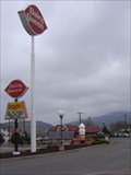
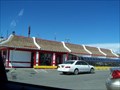 view gallery view galleryW46 km |  McDonald's #6011 - Raton, NM McDonald's #6011 - Raton, NM
in McDonald's Restaurants Take exit 451 off off Interstate 25. posted by: mr.volkswagen location: New Mexico date approved: 03/23/2008 last visited: 09/09/2019 |
|