 view gallery view gallery SW9.5 km SW9.5 km
|   Free Hill(s) Community - Celina TN Free Hill(s) Community - Celina TN
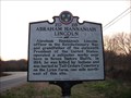
in Civil Rights Memorials Free Hill(s), a historic Black community established near Celina before the Civil War by former slaves of Virginia Hill. Hill brought her slaves from North Carolina to then Overton County, settled and freed them. posted by:  Don.Morfe Don.Morfe location: Tennessee date approved: 11/09/2022 last visited: 11/10/2022 |
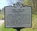
 view gallery view gallerySW9.5 km |  Free Hill(s) Community (2D 31) - Celina TN Free Hill(s) Community (2D 31) - Celina TN
in Tennessee Historical Markers Free Hill(s), a historic Black community, was established northeast of Celina before the Civil War by former slaves of Virginia Hill. posted by: Don.Morfe location: Tennessee date approved: 10/13/2020 last visited: 10/20/2021 |
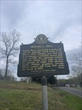
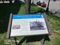 view gallery view gallerySW10.6 km |  Celina During the Civil War-Hamilton's Tennessee Cavalry Battalion - Celina TN Celina During the Civil War-Hamilton's Tennessee Cavalry Battalion - Celina TN
in Civil War Discovery Trail Sites During the Civil War, the residents of the eastern and Cumberland River sections of present-day Clay County (then part of Jackson and Overton Counties) were usually Confederate sympathizers, while those in the western section supported the Union. Men from this area enlisted in both armies. posted by: Don.Morfe location: Tennessee date approved: 05/11/2020 last visited: 10/08/2021 |
 view gallery view gallerySW10.6 km | Celina During the Civil War-Hamilton's Tennessee Cavalry Battalion - Celina TN in U.S. Civil War Sites On April 19, 1863, Union Col. Felix W. Graham’s 5th Indiana Cavalry attacked Hamilton’s command here, routed his forces, destroyed their camp and commissary supplies, and shelled the town. posted by: Don.Morfe location: Tennessee date approved: 05/11/2023 last visited: 05/12/2023 |
 view gallery view gallerySW10.6 km |  Celina During the Civil War - Celina TN Celina During the Civil War - Celina TN
in Battlefields On April 19, 1863, Union Col. Felix W. Graham’s 5th Indiana Cavalry attacked Hamilton’s command here, routed his forces, destroyed their camp and commissary supplies, and shelled the town. posted by: Don.Morfe location: Tennessee date approved: 05/10/2023 last visited: 05/10/2023 |
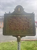
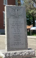 view gallery view gallerySW10.6 km |  Clay County Veterans Monument - Celina TN Clay County Veterans Monument - Celina TN
in Non-Specific Veteran Memorials Clay County Veterans Monument is located on the grounds of the Clay County Courthouse, at 100 Court Square, Celina TN posted by: Don.Morfe location: Tennessee date approved: 05/11/2023 last visited: 05/12/2023 |
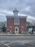 view gallery view gallerySW10.6 km |  Clay County Courthouse (Historical) - Celina, TN Clay County Courthouse (Historical) - Celina, TN
in Courthouses The old historical Clay County Courthouse in Celina, TN. posted by:  Team Geologynut Team Geologynut location: Tennessee date approved: 04/23/2023 last visited: never |
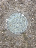
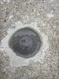
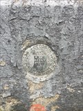 view gallery view gallerySW10.6 km |  A 82 Reset (GB1994) - Celina, TN - Clay County Courthouse A 82 Reset (GB1994) - Celina, TN - Clay County Courthouse
in U.S. Benchmarks A USC&G benchmark mounted vertically in the foundation of the Clay County Courthouse in Celina TN. posted by: Team Geologynut location: Tennessee date approved: 04/12/2023 last visited: never |
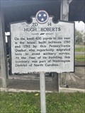 view gallery view gallerySW11.1 km | Hugh Roberts 2D 14 - Celina, Tennessee in Tennessee Historical Markers A Tennessee Historical Marker in Celina, TN at the Clay County Museum. posted by: Team Geologynut location: Tennessee date approved: 04/16/2023 last visited: 04/16/2024 |
 view gallery view gallery E16.1 km E16.1 km
|  Bear Trapp Country Store-Byrdstown,TN Bear Trapp Country Store-Byrdstown,TN
in Bait Shops Popular bait shop located in Byrdstown,TN
posted by: Countrydragon location: Tennessee date approved: 12/02/2009 last visited: 12/01/2009 |
 view gallery view gallery NW16.3 km NW16.3 km
| S 266 (GB2167) - Monroe County, KY in U.S. Benchmarks A USC&G benchmark on a culvert headwall on Center Point Rd. (state hwy 100). Pull off right next to it posted by: Team Geologynut location: Kentucky date approved: 04/10/2023 last visited: never |
 view gallery view galleryNW16.6 km | T 266 (GB2143) - Monroe County KY in U.S. Benchmarks A USC&G benchmark on a bridge abutment on Mud Camp Rd. (state hwy 100). posted by: Team Geologynut location: Kentucky date approved: 04/10/2023 last visited: never |
 view gallery view galleryNW17.4 km | Q 266 (GB2165) - Monroe County, KY in U.S. Benchmarks A USC&G benchmark on a culvert headwall on Center Point Rd. (state hwy 100). Pull off right next to it posted by: Team Geologynut location: Kentucky date approved: 04/10/2023 last visited: never |
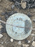 view gallery view galleryNW18 km | N 266 (GB2163) - Monroe County, KY in U.S. Benchmarks A USC&G benchmark on a bridge abutment on Center Point Rd. (state hwy 100). posted by: Team Geologynut location: Kentucky date approved: 04/11/2023 last visited: never |
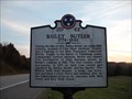 view gallery view gallerySW18.7 km | Bailey Butler in Tennessee Historical Markers A Tennessee Historic Commission sign on Hwy 53 between Celina and Gainesboro TN. posted by: Team Geologynut location: Tennessee date approved: 03/20/2011 last visited: never |
 view gallery view gallery N19.5 km N19.5 km
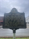
|  The Coe Family #2614 - Burkesville KY The Coe Family #2614 - Burkesville KY
in Kentucky Historical Markers The Coe Family #2614 located in the Cumberland County Courthouse square in Burkesville, KY. posted by: Team Geologynut location: Kentucky date approved: 04/08/2023 last visited: never |
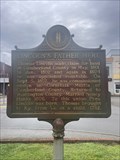 view gallery view galleryN19.5 km | Lincoln's Father Here #885 - Burkesville KY in Kentucky Historical Markers Lincoln's Father Here #885 located in the Cumberland County Courthouse square in Burkesville, KY. posted by: Team Geologynut location: Kentucky date approved: 04/08/2023 last visited: never |
 view gallery view galleryN19.5 km | Cumberland County Courthouse - Burkesville, KY in Courthouses Cumberland County Courthouse located in the middle of Burkesville Kentucky. posted by: Team Geologynut location: Kentucky date approved: 04/07/2023 last visited: never |
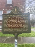 view gallery view galleryN19.6 km | Raiders Entered Here #601 - Burkesville KY in Kentucky Historical Markers Raiders Entered Here #601 located in the Cumberland County Courthouse square in Burkesville, KY. posted by: Team Geologynut location: Kentucky date approved: 04/07/2023 last visited: never |
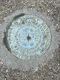
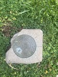 view gallery view galleryN19.6 km | S 43 (GB1332) - Burkesville, KY in U.S. Benchmarks A USC&G benchmark disk on the grounds of the old Cumberland County Courthouse. posted by: Team Geologynut location: Kentucky date approved: 04/10/2023 last visited: never |
 view gallery view galleryN19.6 km | Morgan ~ On To Ohio #515 - Burkesville KY in Kentucky Historical Markers Morgan ~ On To Ohio #515 located in the Cumberland County Courthouse square in Burkesville, KY. posted by: Team Geologynut location: Kentucky date approved: 04/08/2023 last visited: never |
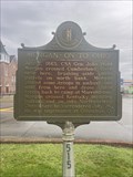
 view gallery view galleryN19.6 km | Cumberland County #959 - Burkesville KY in Kentucky Historical Markers Cumberland County #959 located in the Cumberland County Courthouse square in Burkesville, KY. posted by: Team Geologynut location: Kentucky date approved: 04/08/2023 last visited: never |
 view gallery view galleryN21.1 km | C 251 (GB1342) - Burkesville, Cumberland County KY in U.S. Benchmarks An easy to find USC&G benchmark on a bridge abutment on Glasgow Rd (Hwy 90) NW of Burkesville KY. I parked 175ft west where the shoulder was wide. posted by: Team Geologynut location: Kentucky date approved: 04/10/2023 last visited: never |
 view gallery view gallery W21.2 km W21.2 km
| Moore's Mill #2041 - Tompkinsville, KY in Kentucky Historical Markers Kentucky Historical Marker #2041 SE of Tompkinsville on State Hwy 163.Front side has text, back side has two old metal photos of the mill. posted by: Team Geologynut location: Kentucky date approved: 04/24/2023 last visited: never |
 view gallery view gallerySW21.6 km | Abraham Hannaniah Lincoln in Tennessee Historical Markers A Tennessee Historical Commission sign on Hwy 53 between Celina and Gainesboro TN. posted by: Team Geologynut location: Tennessee date approved: 03/20/2011 last visited: never |
|