 view gallery view gallery SE3.4 km SE3.4 km
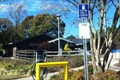
|   Alamace County Rest Area North - I-85 NB - Burlington, NC Alamace County Rest Area North - I-85 NB - Burlington, NC
in Highway Rest Areas The Alamanmace County Rest Area North is located at 3 miles west of Burlington on I-85 Northbound posted by:  outdoorboy34 outdoorboy34 location: North Carolina date approved: 01/27/2017 last visited: never |
 view gallery view gallery NE3.5 km NE3.5 km
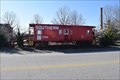
|  Southern X758 - Gibsonville, NC, USA Southern X758 - Gibsonville, NC, USA
in Train Cabooses The caboose is located at a park area adjacent to the train tracks that divide the town of Gibsonville, NC. It serves as a welcome center with historical information for visitors to learn more about the community. posted by:  NCDaywalker NCDaywalker location: North Carolina date approved: 01/03/2019 last visited: never |
 view gallery view galleryNE3.7 km |  Wade's Jewelers Clock - Gibsonville, NC Wade's Jewelers Clock - Gibsonville, NC
in Town Clocks The clock is situated in a tower that serves as an entrance to Wade's Jewelers. posted by: NCDaywalker location: North Carolina date approved: 12/29/2018 last visited: never |
 view gallery view gallery E4.2 km E4.2 km
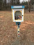
|  Little Free Library #35466, Burlington,NC,USA Little Free Library #35466, Burlington,NC,USA
in Free Community Book Exchanges Book share box near a park entrance posted by: BONSAIRAD location: North Carolina date approved: 02/12/2023 last visited: never |
 view gallery view gallery SW4.2 km SW4.2 km
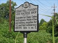
|  Cedar Hill Foundry and Machine Shop .. J 62 Cedar Hill Foundry and Machine Shop .. J 62
in North Carolina Historical Markers Marker describing the old foundry where some of the rifles of the Civil War from Guilford County were manufactured and supplied to the Confederacy. posted by: GeoGordie location: North Carolina date approved: 08/26/2006 last visited: 04/29/2023 |
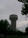 view gallery view galleryE4.3 km |  Burlington, NC newest water tower Burlington, NC newest water tower
in Water Towers Burlington, NC newest water tower posted by: rtmlee location: North Carolina date approved: 07/25/2007 last visited: 12/07/2020 |
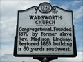 view gallery view gallerySW4.7 km | Wadsworth Church | J-107 in North Carolina Historical Markers Located on Rock Creek Dairy Road southeast of Sedalia posted by: 3newsomes location: North Carolina date approved: 02/09/2009 last visited: 12/26/2018 |
 view gallery view gallery NW4.8 km NW4.8 km
|  J. Razz & Tazz Farm Haunted Hay Ride - Gibsonville NC J. Razz & Tazz Farm Haunted Hay Ride - Gibsonville NC
in Haunted Attractions At the dead-end of Peeden Dr. Off Bethel Church Rd. Behind eastern Guilford Middle School. posted by: fatcat161 location: North Carolina date approved: 04/01/2010 last visited: never |
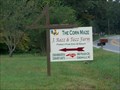 view gallery view galleryNW4.8 km |  J. Razz & Tazz Farm - Gibsonville NC J. Razz & Tazz Farm - Gibsonville NC
in Outdoor Mazes At the dead-end of peeden dr. Off Bethel Church Rd.
Behind eastern Guilford Middle School.
posted by: fatcat161 location: North Carolina date approved: 09/26/2009 last visited: 11/26/2011 |
 view gallery view gallery W5 km W5 km
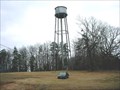
| Palmer Memorial Institute Tank, Sedalia NC in Water Towers Old water tank, circa 1929. posted by: PFF location: North Carolina date approved: 06/25/2006 last visited: 12/26/2018 |
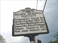 view gallery view galleryW5.1 km | Palmer Memorial Institute in North Carolina Historical Markers Located in Guilford County .. Sedalia, NC. Charlotte Hawkins (1883-1961), born in Henderson, North Carolina, was a northern-educated granddaughter of former slaves. She returned to her home state as a teacher in 1901, and the following year established the Alice Freeman Palmer Memorial Institute at Sedalia, near Greensboro. posted by: GeoGordie location: North Carolina date approved: 04/16/2006 last visited: 07/21/2021 |
 view gallery view gallery N5.5 km N5.5 km
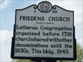
| Friedens Church | J-99 in North Carolina Historical Markers Located on NC 61 at SR 2746 (Friedens Church Road) north of Gibsonville posted by: 3newsomes location: North Carolina date approved: 02/09/2009 last visited: 12/26/2018 |
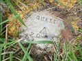 view gallery view gallerySE6 km |  QUAIL QUAIL
in U.S. Benchmarks Height Modernization Station, Alamance County NC. Set in 2003. posted by: PFF location: North Carolina date approved: 08/16/2006 last visited: never |
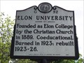 view gallery view galleryNE6 km | Elon University | G-52 in North Carolina Historical Markers Located on NC 100 (Hoggard Avenue) in Elon College posted by: 3newsomes location: North Carolina date approved: 04/01/2009 last visited: 12/26/2018 |
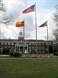 view gallery view galleryNE6 km |  Elon University - Elon, North Carolina Elon University - Elon, North Carolina
in Universities and Colleges A private, liberal arts university located in Elon, North Carolina.
posted by: Countrydragon location: North Carolina date approved: 12/24/2009 last visited: 12/26/2018 |
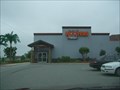 view gallery view galleryE6.1 km |  Hooters of Burlington, NC Hooters of Burlington, NC
in Hooters Restaurants Located on Garden Rd just off of I-40 in Burlington, NC. posted by: fatcat161 location: North Carolina date approved: 05/07/2009 last visited: 11/28/2015 |
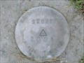 view gallery view galleryE7.7 km | STONE in U.S. Benchmarks Height Modernization Station in Alamance County, NC. Set in 2003. posted by: PFF location: North Carolina date approved: 08/16/2006 last visited: never |
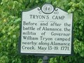 view gallery view gallerySE8.4 km | Tryon's Camp, Marker G-60 in North Carolina Historical Markers This marker commemorates the location of Governor Tryon’s camp before and after the Battle of Alamance. The marker is located on NC Route 62 in Alamance next to Alamance Creek. posted by: showbizkid location: North Carolina date approved: 03/30/2006 last visited: 01/11/2019 |
 view gallery view gallerySE8.4 km | Alamance Cotton Mill, Marker G-82 in North Carolina Historical Markers The site of the historic Alamance Cotton Mill. The marker is located on NC Route 62 in Alamance near Alamance Creek. posted by: showbizkid location: North Carolina date approved: 03/29/2006 last visited: 01/11/2019 |
 view gallery view gallerySE8.4 km |  Johnston Moves West-Holt's Mill - Alamance, NC Johnston Moves West-Holt's Mill - Alamance, NC
in U.S. Civil War Sites Confederate Gen. William J. Hardee led Gen. Joseph E. Johnston's southern column of the Army of Tennessee here to Holt's Mill on the rainy morning of April 15, 1865. posted by: Don.Morfe location: North Carolina date approved: 04/07/2023 last visited: 04/07/2023 |
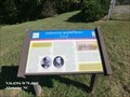 view gallery view gallerySE8.4 km | Johnston Moves West-Holt's Mill - Alamance, NC in Civil War Discovery Trail Sites Confederate Gen. William J. Hardee led Gen. Joseph E. Johnston's southern column of the Army of Tennessee here to Holt's Mill on the rainy morning of April 15, 1865 posted by: Don.Morfe location: North Carolina date approved: 03/09/2020 last visited: 10/08/2021 |
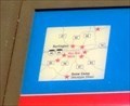 view gallery view gallerySE8.4 km |  You Are Here Map-Johnston Moves West-Holt's Mill - Alamance, NC You Are Here Map-Johnston Moves West-Holt's Mill - Alamance, NC
in 'You Are Here' Maps The You Are Here Map shows that you are on Alamance Road in Alamance, NC posted by: Don.Morfe location: North Carolina date approved: 04/07/2023 last visited: 04/07/2023 |
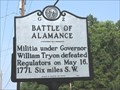 view gallery view galleryE8.7 km | Battle of Alamance, Marker G-2 in North Carolina Historical Markers The Battle of Alamance was the final skirmish in the War of the Regulation, a rebellion in colonial North Carolina over issues of taxation and local control. This marker is located along NC State Route 62 about 1/2 mile south of I-40/I-85. posted by: showbizkid location: North Carolina date approved: 03/29/2006 last visited: 12/17/2017 |
 view gallery view gallery S8.7 km S8.7 km
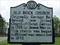
| Old Brick Church | J-57 in North Carolina Historical Markers Located on SR 3110 (Brick Church Road) at SR 3111 (May Road) south of Whitsett posted by: 3newsomes location: North Carolina date approved: 01/27/2009 last visited: 12/17/2017 |
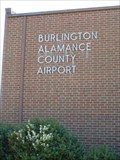 view gallery view gallerySE8.7 km |  Burlington-Alamance Regional Airport - Burlington, NC Burlington-Alamance Regional Airport - Burlington, NC
in Airports Burlington-Alamance Regional Airport is located between Burlington and Alamance in Alamance County, NC. posted by: showbizkid location: North Carolina date approved: 03/26/2006 last visited: 04/05/2006 |
|