 view gallery view gallery N1 km N1 km
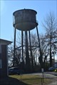
|   CT Nassau Water Tower - Alamance, NC, USA CT Nassau Water Tower - Alamance, NC, USA
in Water Towers The somewhat short squat rusting water tower is located behind offices for a facility that makes mattress ticking. posted by:  NCDaywalker NCDaywalker location: North Carolina date approved: 12/18/2017 last visited: 01/11/2019 |
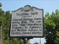 view gallery view galleryN1 km |  Trading Path, Marker G-35 Trading Path, Marker G-35
in North Carolina Historical Markers The Trading Path route in Alamance County is commemorated here. The marker is located on NC Route 62 in Alamance. posted by:  showbizkid showbizkid location: North Carolina date approved: 03/29/2006 last visited: 12/17/2017 |
 view gallery view galleryN1.3 km | Alamance Cotton Mill, Marker G-82 in North Carolina Historical Markers The site of the historic Alamance Cotton Mill. The marker is located on NC Route 62 in Alamance near Alamance Creek. posted by: showbizkid location: North Carolina date approved: 03/29/2006 last visited: 01/11/2019 |
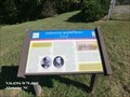 view gallery view galleryN1.3 km |  Johnston Moves West-Holt's Mill - Alamance, NC Johnston Moves West-Holt's Mill - Alamance, NC
in Civil War Discovery Trail Sites Confederate Gen. William J. Hardee led Gen. Joseph E. Johnston's southern column of the Army of Tennessee here to Holt's Mill on the rainy morning of April 15, 1865 posted by: Don.Morfe location: North Carolina date approved: 03/09/2020 last visited: 10/08/2021 |
 view gallery view galleryN1.3 km | Johnston Moves West-Holt's Mill - Alamance, NC in U.S. Civil War Sites Confederate Gen. William J. Hardee led Gen. Joseph E. Johnston's southern column of the Army of Tennessee here to Holt's Mill on the rainy morning of April 15, 1865. posted by: Don.Morfe location: North Carolina date approved: 04/07/2023 last visited: 04/07/2023 |
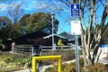
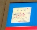 view gallery view galleryN1.3 km |  You Are Here Map-Johnston Moves West-Holt's Mill - Alamance, NC You Are Here Map-Johnston Moves West-Holt's Mill - Alamance, NC
in 'You Are Here' Maps The You Are Here Map shows that you are on Alamance Road in Alamance, NC posted by: Don.Morfe location: North Carolina date approved: 04/07/2023 last visited: 04/07/2023 |
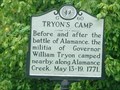 view gallery view galleryN1.3 km | Tryon's Camp, Marker G-60 in North Carolina Historical Markers This marker commemorates the location of Governor Tryon’s camp before and after the Battle of Alamance. The marker is located on NC Route 62 in Alamance next to Alamance Creek. posted by: showbizkid location: North Carolina date approved: 03/30/2006 last visited: 01/11/2019 |
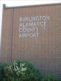 view gallery view galleryN2.6 km |  Burlington-Alamance Regional Airport - Burlington, NC Burlington-Alamance Regional Airport - Burlington, NC
in Airports Burlington-Alamance Regional Airport is located between Burlington and Alamance in Alamance County, NC. posted by: showbizkid location: North Carolina date approved: 03/26/2006 last visited: 04/05/2006 |
 view gallery view gallery SW2.6 km SW2.6 km
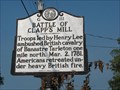
| Battle of Clapp's Mill, Marker G-111 in North Carolina Historical Markers This marker commemorates the Battle of Clapp's Mill during the Revolutionary War. Located on NC State Route 62 southwest of Alamance. posted by: showbizkid location: North Carolina date approved: 03/29/2006 last visited: 12/17/2017 |
 view gallery view gallery E2.7 km E2.7 km
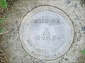
|  Chriscoe Chriscoe
in U.S. Benchmarks Height Modernization Station DG7056, Alamance County NC. Placed in 2003. posted by: PFF location: North Carolina date approved: 08/16/2006 last visited: never |
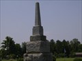 view gallery view gallerySW2.9 km |  Battle of Alamance Battle of Alamance
in Obelisks Located on 5803 N.C. 62 S in Alamance, NC, US posted by: Countrydragon location: North Carolina date approved: 12/19/2009 last visited: 01/11/2019 |
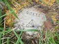 view gallery view gallery NW3.2 km NW3.2 km
| QUAIL in U.S. Benchmarks Height Modernization Station, Alamance County NC. Set in 2003. posted by: PFF location: North Carolina date approved: 08/16/2006 last visited: never |
 view gallery view galleryE3.2 km | W 3 (DG7091) in U.S. Benchmarks Height modernization station in Alamance County, NC. Set in 1963, with high-accuracy positioning done in 2003. posted by: PFF location: North Carolina date approved: 08/16/2006 last visited: never |
 view gallery view gallerySW3.5 km | Battle of Alamance, GG-2 in North Carolina Historical Markers On May 16, 1771, North Carolina militia, commanded by Royal Governor William Tryon, defeated the Regulators on this site. The pennants represent the second, or decisive, positions of the two armies and the Regulator camp. posted by: drmellow location: North Carolina date approved: 09/11/2007 last visited: 12/17/2017 |
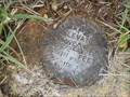
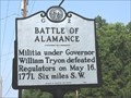 view gallery view galleryN3.5 km | Battle of Alamance, Marker G-2 in North Carolina Historical Markers The Battle of Alamance was the final skirmish in the War of the Regulation, a rebellion in colonial North Carolina over issues of taxation and local control. This marker is located along NC State Route 62 about 1/2 mile south of I-40/I-85. posted by: showbizkid location: North Carolina date approved: 03/29/2006 last visited: 12/17/2017 |
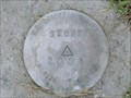 view gallery view galleryN3.5 km | STONE in U.S. Benchmarks Height Modernization Station in Alamance County, NC. Set in 2003. posted by: PFF location: North Carolina date approved: 08/16/2006 last visited: never |
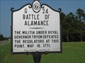 view gallery view gallerySW3.5 km | Battle of Alamance, Marker G-24 in North Carolina Historical Markers This marker is located on the battlefield of the Battle of Alamance. This was the final skirmish in the War of the Regulation, a rebellion in colonial North Carolina over issues of taxation and local control. Located on NC State Route 62 southwest of Alamance. posted by: showbizkid location: North Carolina date approved: 03/30/2006 last visited: 01/11/2019 |
 view gallery view gallerySW3.5 km |  Battle of Alamance Battle of Alamance
in Battlefields NC 62 N and Spooner Mill Rd.
Alamance Battleground
Alamance, NC, US
posted by: Countrydragon location: North Carolina date approved: 12/22/2009 last visited: 01/11/2019 |
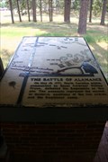
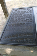
 view gallery view gallerySW3.7 km | Battle of Alamance, GG-1 in North Carolina Historical Markers Large rectangular marker with map showing details of the Battle off Alamance, fought May 16, 1771. posted by: drmellow location: North Carolina date approved: 09/11/2007 last visited: 01/11/2019 |
 view gallery view gallery NE4.5 km NE4.5 km
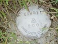
| KENNEL in U.S. Benchmarks Height Modernization Station in Alamance County, NC. Placed in 2003. posted by: PFF location: North Carolina date approved: 08/16/2006 last visited: never |
 view gallery view galleryE4.5 km | TIMBER in U.S. Benchmarks Height modernization station in Alamance County, NC. Set in 2003. posted by: PFF location: North Carolina date approved: 08/16/2006 last visited: never |
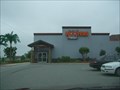 view gallery view galleryN4.7 km |  Hooters of Burlington, NC Hooters of Burlington, NC
in Hooters Restaurants Located on Garden Rd just off of I-40 in Burlington, NC. posted by: fatcat161 location: North Carolina date approved: 05/07/2009 last visited: 11/28/2015 |
 view gallery view galleryNW5.6 km |  Alamace County Rest Area North - I-85 NB - Burlington, NC Alamace County Rest Area North - I-85 NB - Burlington, NC
in Highway Rest Areas The Alamanmace County Rest Area North is located at 3 miles west of Burlington on I-85 Northbound posted by: outdoorboy34 location: North Carolina date approved: 01/27/2017 last visited: never |
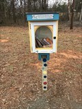 view gallery view galleryNW5.8 km |  Little Free Library #35466, Burlington,NC,USA Little Free Library #35466, Burlington,NC,USA
in Free Community Book Exchanges Book share box near a park entrance posted by: BONSAIRAD location: North Carolina date approved: 02/12/2023 last visited: never |
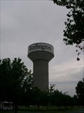 view gallery view galleryNW5.8 km | Burlington, NC newest water tower in Water Towers Burlington, NC newest water tower posted by: rtmlee location: North Carolina date approved: 07/25/2007 last visited: 12/07/2020 |
|