 view gallery view gallery SW1 km SW1 km
|   Buckner Gap - I-26W - NC Buckner Gap - I-26W - NC
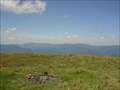
in Scenic Roadside Look-Outs A view of the Black Mountains, including Mt. Mitchell, from Interstate 26 pull-off. posted by:  vhasler vhasler location: North Carolina date approved: 03/29/2013 last visited: 05/28/2017 |
 view gallery view gallery W1.6 km W1.6 km
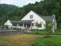
|  I-26 Eastbound Lane - NC Welcome Center I-26 Eastbound Lane - NC Welcome Center
in Highway Rest Areas 7 miles east of TN/NC is a relatively new North Carolina Welcome Center posted by: vhasler location: North Carolina date approved: 08/29/2010 last visited: 04/02/2021 |
 view gallery view gallery NW3.1 km NW3.1 km
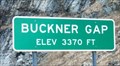
|  Buckner Gap Buckner Gap
in Named Mountain Gaps Along I-26. Elevation 3370 feet. posted by: vhasler location: North Carolina date approved: 03/30/2013 last visited: 06/05/2018 |
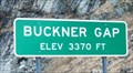 view gallery view galleryNW3.1 km |  Buckner Gap - 3370 ft Buckner Gap - 3370 ft
in Elevation Signs Along I-26 West (north) bound. posted by: vhasler location: North Carolina date approved: 03/29/2013 last visited: 05/05/2019 |
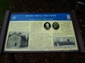
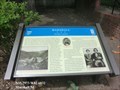
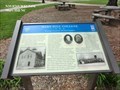 view gallery view gallerySW5.3 km |  Mars Hill College-Strategic Location, Divided Loyalties - Mars Hill Mars Hill College-Strategic Location, Divided Loyalties - Mars Hill
in U.S. Civil War Sites Confederate troops left Mars Hill to forage in March 1865. Col. George W. Kirk led his 3rd North Carolina Mounted Infantry (U.S.) into the village and burned the college dormitory and teachers' residence. posted by:  Don.Morfe Don.Morfe location: North Carolina date approved: 04/20/2023 last visited: 04/20/2023 |
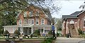 view gallery view gallerySW5.3 km |  Mars Hill University - Mars Hill NC Mars Hill University - Mars Hill NC
in Universities and Colleges Mars Hill University was founded as the French Broad Baptist Institute in Madison County in 1856, in the days leading up to the Civil War. Shortly thereafter, the name was changed to Mars Hill College. posted by: Don.Morfe location: North Carolina date approved: 04/20/2023 last visited: 04/20/2023 |
 view gallery view gallerySW5.3 km | Mars Hill College Strategic Location, Divided Loyalties - Mars Hill in Madison County, North Carolina in Civil War Discovery Trail Sites Marker is in Mars Hill, North Carolina, in Madison County. posted by: Countrydragon location: North Carolina date approved: 01/01/2010 last visited: 04/20/2023 |
 view gallery view gallerySW5.3 km |  Mars Hill College-Strategic Location, Divided Loyalties - Mars Hill Mars Hill College-Strategic Location, Divided Loyalties - Mars Hill
in Battlefields Confederate troops left Mars Hill to forage in March 1865. Col. George W. Kirk led his 3rd North Carolina Mounted Infantry (U.S.) into the village and burned the college dormitory and teachers' residence. posted by: Don.Morfe location: North Carolina date approved: 04/21/2023 last visited: 04/20/2023 |
 view gallery view gallery S5.5 km S5.5 km
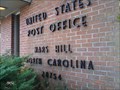
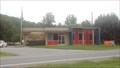
|  Mars Hill, NC 28754 Mars Hill, NC 28754
in U.S. Post Offices The Mars Hill, NC Post Office. posted by: papermanone & catlover location: North Carolina date approved: 01/02/2007 last visited: 01/02/2015 |
 view gallery view gallery N9.7 km N9.7 km
|  TN/NC on I-26 TN/NC on I-26
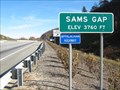
in Border Crossings I-26 over the Appalachian Mountains through Sams Gap to connect Asheville, NC and Tricities region of Tennessee. posted by: vhasler location: North Carolina date approved: 11/02/2010 last visited: 01/02/2015 |
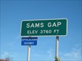 view gallery view galleryN9.7 km | Sams Gap - 3760 Ft - NC/TN border in Elevation Signs Sams Gap through which I-26 now flows between Asheville, NC and Tricities region of Tennessee. posted by: vhasler location: North Carolina date approved: 10/31/2010 last visited: never |
 view gallery view galleryN9.7 km | Sams Gap - NC/TN Border in Named Mountain Gaps Interstate 26 now passes through Sams Gap at the Tenn/NC border posted by: vhasler location: Tennessee date approved: 10/31/2010 last visited: 05/05/2019 |
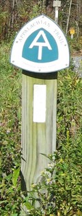 view gallery view galleryN9.7 km |  Appalachian Trail - Georgia to Maine Appalachian Trail - Georgia to Maine
in Long Distance Hiking Trails First (1968) completed national scenic trail is also the longest in the United States. posted by: vhasler location: North Carolina date approved: 11/07/2010 last visited: 08/02/2017 |
 view gallery view galleryN9.8 km |  Divide Cemetery ~ Madison County, North Carolina ~ USA. Divide Cemetery ~ Madison County, North Carolina ~ USA.
in Worldwide Cemeteries Also known as State Line Cemetery as it is in both North Carolina and Tennessee in Sam's Gap near the AT crossing. posted by: Manville Possum location: North Carolina date approved: 07/08/2019 last visited: 07/20/2019 |
 view gallery view gallery SE12.2 km SE12.2 km
| Barnardsville - Barnardsville, NC 28709 in U.S. Post Offices Near the end of the road... posted by: DnRseekers location: North Carolina date approved: 08/15/2013 last visited: 08/09/2013 |
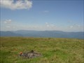 view gallery view galleryN13.5 km |  Big Bald - Highest Point in Unicoi County, TN Big Bald - Highest Point in Unicoi County, TN
in Geographic High Points Big Bald is right at the TN/NC state line - and the Applachian Trail runs across the peak. posted by: vhasler location: Tennessee date approved: 11/03/2009 last visited: never |
 view gallery view galleryN13.5 km |  Big Bald Mountain - TN/NC border Big Bald Mountain - TN/NC border
in American Guide Series A high point on the Appalachian Trail has an old story to tell... posted by: vhasler location: North Carolina date approved: 07/20/2013 last visited: never |
 view gallery view gallerySW16.4 km | Marshall-Divided Loyalties - Marshall NC in Battlefields The local “war within a war” had escalated in the mountains by January 1863, when Unionists from the county’s Shelton Laurel community were deprived of salt. posted by: Don.Morfe location: North Carolina date approved: 04/20/2023 last visited: 04/20/2023 |
 view gallery view gallerySW16.4 km | Marshall-Divided Loyalties - Marshall NC in U.S. Civil War Sites The local “war within a war” had escalated in the mountains by January 1863, when Unionists from the county’s Shelton Laurel community were deprived of salt. posted by: Don.Morfe location: North Carolina date approved: 04/20/2023 last visited: 04/20/2023 |
 view gallery view gallerySW16.4 km | Marshall-Divided Loyalties - Marshall NC in Civil War Discovery Trail Sites On May 13, 1861, voters gathered here in Marshall, the Madison County seat, to elect a delegate for the Secession Convention to be held in Raleigh. posted by: Don.Morfe location: North Carolina date approved: 04/27/2020 last visited: 10/08/2021 |
 view gallery view gallerySW16.4 km | Robert E. Lee-Dixie Highway - Marshall NC in U.S. Civil War Sites In loving memory of Robert E. Lee and to mark the route of the
Dixie Highway. posted by: Don.Morfe location: North Carolina date approved: 10/11/2020 last visited: 10/01/2021 |
 view gallery view gallerySW16.4 km |  Dixie Highway-Bus US 25/70-Marshall, NC Dixie Highway-Bus US 25/70-Marshall, NC
in Dixie Highway Located in front of the courthouse in Marshall. posted by: Markerman62 location: North Carolina date approved: 01/11/2019 last visited: 04/20/2023 |
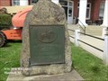
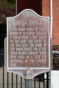 view gallery view gallerySW16.4 km |  David Vance David Vance
in North Carolina Historical Markers Located in front of the Madison County Courthouse on Business US 25 posted by: Markerman62 location: North Carolina date approved: 01/10/2019 last visited: 04/20/2023 |
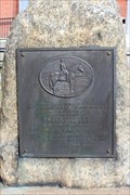
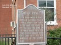 view gallery view gallerySW16.4 km |  David Vance - Marshall NC David Vance - Marshall NC
in Signs of History LOCATION: Marker is in Marshall, North Carolina, in Madison County. Marker is at the intersection of Main Street and Bridge Street on Main Street. Marker is at or near this postal address: 58 Main St, Marshall NC 28753, United States of America. posted by: Don.Morfe location: North Carolina date approved: 10/10/2020 last visited: 09/25/2021 |
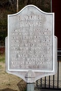 view gallery view gallerySW16.4 km | Buncombe Turnpike in North Carolina Historical Markers Located in front of the Madison County Courthouse on Bus.US 25, Marshall posted by: Markerman62 location: North Carolina date approved: 01/10/2019 last visited: 12/30/2018 |
|