 view gallery view gallery W10 km W10 km
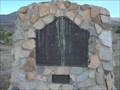
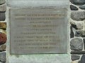
|   Valley Wells Valley Wells
in California Historical Markers Located on Trona Wildrose Rd at Valley Wells Rd, 5.5 mi NE of Trona. Looks like the birds visit this one more often than others. posted by:  fresgo fresgo location: California date approved: 04/17/2011 last visited: 09/01/2018 |
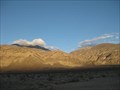
 view gallery view galleryW15.1 km |  "T" is for Trona, CA. "T" is for Trona, CA.
in Letters on Hills Large white "T" on the hills above Trona, CA. posted by: Six Little Spookies location: California date approved: 03/25/2008 last visited: 03/17/2014 |
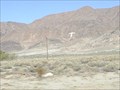
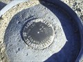 view gallery view gallery SW24 km SW24 km
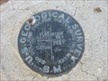
|  CALDOT Survey Disk CALDOT Survey Disk
in U.S. Benchmarks California Department of Transportation benchmark along Highway 178. posted by: Six Little Spookies location: California date approved: 03/28/2008 last visited: 09/03/2011 |
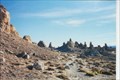
 view gallery view gallerySW24.6 km |  Trona Pinnacles, 'Star Trek 5: The Final Frontier', Various films & TV shows- Ridgecrest California Trona Pinnacles, 'Star Trek 5: The Final Frontier', Various films & TV shows- Ridgecrest California
in Movie Locations Trona Pinnacles Recreation Lands, an area in the Searles Dry Lake Bed in Trona, San Bernardino County, central California was used as planetary place, 'Sha Ka Ree'. It was also used in various films and TV shows. posted by:  calgriz calgriz location: California date approved: 05/14/2014 last visited: 01/14/2014 |
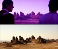 view gallery view gallerySW24.6 km |  'Star Trek 5: The Final Frontier'- 'Trona Pinnacles- Ridgecrest California 'Star Trek 5: The Final Frontier'- 'Trona Pinnacles- Ridgecrest California
in Star Trek Star Trek V: The Final Frontier filming location: ‘Nimbus III in the Neutral Zone, the Planet of Galactic Peace’- Owens Dry Lake in the Mojave Desert, north of Mojave, California near Ridgecrest CA between Routes 395 and 136. posted by: calgriz location: California date approved: 06/29/2014 last visited: 12/30/2014 |
 view gallery view gallerySW24.8 km | Trona Pinnacles - Trona, CA in Star Trek Located about 7 miles south of State Highway 178 and about 20 miles east of Ridgecrest, California.
posted by: lazyCachers location: California date approved: 08/03/2008 last visited: 12/30/2014 |
 view gallery view gallerySW24.8 km |  Trona Pinnacles Trona Pinnacles
in U.S. National Natural Landmarks Located about 7 miles south of State Highway 178 and about 20 miles east of Ridgecrest, California. posted by: lazyCachers location: California date approved: 01/02/2009 last visited: 09/21/2013 |
 view gallery view gallerySW24.8 km |  Trona Pinnacles - Trona, CA Trona Pinnacles - Trona, CA
in Places of Geologic Significance Located about 7 miles south of State Highway 178 and about 20 miles east of Ridgecrest, California. posted by: lazyCachers location: California date approved: 08/02/2008 last visited: 09/21/2013 |
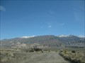
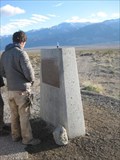 view gallery view gallery N25.3 km N25.3 km
|  Panamint City Panamint City
in E Clampus Vitus Historical Markers One of three markers describing the area around this pulloff west of Death Valley. posted by: ChapterhouseInc location: California date approved: 02/25/2011 last visited: 10/11/2015 |
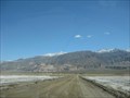
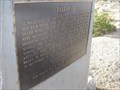 view gallery view galleryN25.3 km | Ballarat in E Clampus Vitus Historical Markers One of three markers located along the highway west of Death Valley, near the Ballarat Ghost Town. posted by: ChapterhouseInc location: California date approved: 02/25/2011 last visited: 03/18/2014 |
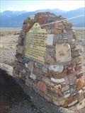 view gallery view galleryN25.3 km |  Ballarat (3 1/2 miles) Ballarat (3 1/2 miles)
in Signs of History One of several markers describing this valley west of Death Valley. posted by: ChapterhouseInc location: California date approved: 02/25/2011 last visited: 03/17/2014 |
 view gallery view galleryN26.4 km | Ballarat in Signs of History A small historic marker in this ghost town. posted by: ChapterhouseInc location: California date approved: 02/25/2011 last visited: 02/19/2011 |
 view gallery view galleryN26.4 km |  Ballarat, California Ballarat, California
in Ghost Towns A virtual ghost town serves as a off road base. posted by: ChapterhouseInc location: California date approved: 02/24/2011 last visited: 08/13/2011 |
 view gallery view galleryN26.4 km |  Ballarat, California Ballarat, California
in Wikipedia Entries A virtual ghost town serves as a off road base. posted by: ChapterhouseInc location: California date approved: 02/24/2011 last visited: 03/18/2014 |
 view gallery view galleryN26.6 km |  RV Lot - Ballarat, CA RV Lot - Ballarat, CA
in Free Overnight RV Parking Locations This Ghost Town near Surprise Canyon Wilderness Area has a large lot to accomodate RVs. posted by: ChapterhouseInc location: California date approved: 02/26/2011 last visited: 02/14/2015 |
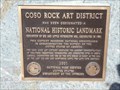 view gallery view gallerySW32.7 km | Coso Rock Art District Ridgecrest CA in U.S. National Natural Landmarks This district possesses national significance in commemorating the history of the USA. It contains the largest concentration of unaltered prehistoric petroglyphs in North America. Dates at the end of the last ice age. desig 1964; mark expanded2001 posted by: sbcamper location: California date approved: 12/23/2018 last visited: never |
 view gallery view galleryN33 km | GS0341 - 1082 in U.S. Benchmarks A benchmark along Indian Ranch Rd in the BLM Ridgecrest area. posted by: ChapterhouseInc location: California date approved: 02/24/2011 last visited: 02/14/2011 |
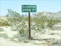 view gallery view gallerySW33.6 km |  2000 feet, between Ridgecrest and Trona, CA 2000 feet, between Ridgecrest and Trona, CA
in Elevation Signs Elevation sign outside Ridgecrest, CA. posted by: Six Little Spookies location: California date approved: 03/25/2008 last visited: 09/25/2013 |
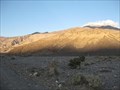 view gallery view galleryN33.8 km |  Surprise Canyon - Ridgecrest, CA Surprise Canyon - Ridgecrest, CA
in Free Campsites A BLM property has several established camping areas along Indian Ranch Rd. posted by: ChapterhouseInc location: California date approved: 02/27/2011 last visited: 02/16/2011 |
 view gallery view galleryN33.8 km |  Surprise Canyon Wilderness Area - Ridgecrest, CA Surprise Canyon Wilderness Area - Ridgecrest, CA
in Public Access Lands A BLM property serves as a Death Valley National Park addition. posted by: ChapterhouseInc location: California date approved: 02/27/2011 last visited: 02/16/2011 |
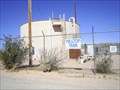 view gallery view gallerySW38.5 km |  Hilltop Water Tank Hilltop Water Tank
in Water Towers Hilltop Water Tank posted by: Six Little Spookies location: California date approved: 03/25/2008 last visited: 09/25/2013 |
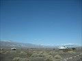
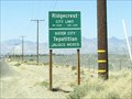 view gallery view gallerySW42 km | Ridgecrest, CA, 2,220 feet above sea level in Elevation Signs City limit sign for Ridgecrest, CA. posted by: Six Little Spookies location: California date approved: 04/05/2008 last visited: 09/25/2013 |
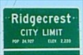 view gallery view gallerySW42 km |  Ridgecrest, CA Ridgecrest, CA
in Population Signs Ridgecrest, CA, pop. 24927 posted by: Six Little Spookies location: California date approved: 04/05/2008 last visited: 03/17/2014 |
 view gallery view gallerySW43.8 km |  Taco Bell - N. China Lake Blvd - Ridgecrest, CA Taco Bell - N. China Lake Blvd - Ridgecrest, CA
in Taco Bell Restaurants This is the Taco Bell location in Ridgecrest, CA. posted by: retail96 location: California date approved: 08/02/2020 last visited: never |
 view gallery view gallerySW44.1 km |  Domino's - N. China Lake Blvd - Ridgecrest, CA Domino's - N. China Lake Blvd - Ridgecrest, CA
in Domino's Pizza This is the Domino's location in Ridgecrest, CA. posted by: retail96 location: California date approved: 08/02/2020 last visited: never |
|