 view gallery view gallery NW1.6 km NW1.6 km
|   Smokey at Cochiti, New Mexico Smokey at Cochiti, New Mexico
in Smokey Bear Sign Sightings Smokey Bear sign at Pueblo and Indian Service Rte, New Mexico posted by:  kallehaugerne kallehaugerne location: New Mexico date approved: 07/18/2018 last visited: never |
 view gallery view gallery NE2.3 km NE2.3 km
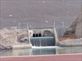
|  Cochiti Dam - Cochiti Pueblo, New Mexico Cochiti Dam - Cochiti Pueblo, New Mexico
in Water Dams Cochiti Lake is on the Rio Grande, about half way between Santa Fe and Albuquerque. Cochiti Dam is one of the ten largest earthfill dams in the US. posted by:  GT.US GT.US location: New Mexico date approved: 04/30/2010 last visited: 07/23/2009 |
 view gallery view galleryNW2.3 km |  Kasha-Katuwe Tent Rocks National Monument - New Mexico Kasha-Katuwe Tent Rocks National Monument - New Mexico
in National Parks of the World Kasha-Katuwe Tent Rocks is a National Monument located between Albuquerque and Santa Fe. Tent Rocks was established as a U.S. National Monument by President Bill Clinton in January 2001 shortly before leaving office. posted by: GT.US location: New Mexico date approved: 04/01/2010 last visited: 05/26/2016 |
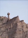 view gallery view galleryNW9 km |  Kasha-Katuwe Tent Rocks National Monument - New Mexico Kasha-Katuwe Tent Rocks National Monument - New Mexico
in Nature's Balanced Rocks There are multiple examples of balanced rocks in the Tent Rock National Monument area. posted by: GT.US location: New Mexico date approved: 03/07/2010 last visited: 05/26/2016 |
 view gallery view galleryNW9 km |  Tent Rocks cave loop trail - Tent Rocks National Monument, New Mexico Tent Rocks cave loop trail - Tent Rocks National Monument, New Mexico
in Self Guided Walks and Trails The Cave Trail Loop in the Tent rocks is about 1.2 miles long with some altitude rise along the way. posted by: GT.US location: New Mexico date approved: 03/01/2010 last visited: 07/23/2009 |
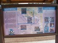
 view gallery view galleryNW9 km |  Kasha-Katuwe Tent Rocks history - New Mexico Kasha-Katuwe Tent Rocks history - New Mexico
in Signs of History This sign was found on a trail that goes through the Kasha-Katuwe Tent Rocks National Monument. It tells the history of these formations. posted by: GT.US location: New Mexico date approved: 03/10/2010 last visited: 01/10/2011 |
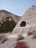 view gallery view galleryNW9.5 km | ") Indian Shelter Cave - Tent Rocks National Monument - New Mexico Indian Shelter Cave - Tent Rocks National Monument - New Mexico
in Cave Entrances (Natural) This is a small shelter cave, most likely used by Indian hunters. posted by: GT.US location: New Mexico date approved: 03/01/2010 last visited: 07/23/2009 |
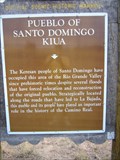 view gallery view gallery S9.5 km S9.5 km
|  Pueblo of Santo Domingo Kiua Pueblo of Santo Domingo Kiua
in New Mexico Historical Markers This New Mexico OSHM is at bottom of ramp from NM-22 onto BIA-88. posted by: leadhiker location: New Mexico date approved: 10/13/2011 last visited: never |
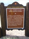 view gallery view galleryS14.3 km | Kewa Women's Co-op - Santo Domingo Pueblo in New Mexico Historical Markers This New Mexico Historic Women Marker is just west of I-25 at exit 259. posted by: leadhiker location: New Mexico date approved: 10/13/2011 last visited: never |
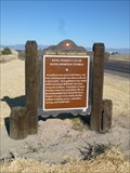 view gallery view galleryS14.3 km | Kewa Women's Co-op - Santo Domingo Pueblo in New Mexico Historical Markers Not much to see here, just the marker. posted by: Go Boilers! location: New Mexico date approved: 10/21/2011 last visited: never |
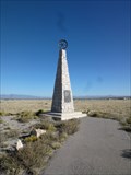 view gallery view galleryS16.6 km | Mormon Battalion - Sandoval County, New Mexico in New Mexico Historical Markers At the end of a lonely frontage road. posted by: Go Boilers! location: New Mexico date approved: 10/22/2011 last visited: 10/13/2015 |
 view gallery view galleryS16.6 km |  Mormon Battalion, Mexican–American War, Sandoval County, New Mexico, USA Mormon Battalion, Mexican–American War, Sandoval County, New Mexico, USA
in Specific Wars Monuments and Memorials At the end of a lonely frontage road. posted by: Go Boilers! location: New Mexico date approved: 07/24/2012 last visited: 08/24/2019 |
 view gallery view galleryS16.6 km | The Mormon Battalion in New Mexico Historical Markers This monument is well worth the short side trip off I-25 to take a look. posted by: leadhiker location: New Mexico date approved: 10/13/2011 last visited: 07/05/2015 |
 view gallery view gallery SE18.5 km SE18.5 km
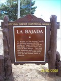
| La Bajada ("the descent") in New Mexico Historical Markers La Bajada ("the descent") Official Scenic Historical Marker posted by: Avi8torAce location: New Mexico date approved: 02/26/2008 last visited: 11/25/2020 |
 view gallery view gallerySE18.5 km | Gold and Turquoise in New Mexico Historical Markers Official Scenic Marker posted by: Avi8torAce location: New Mexico date approved: 02/26/2008 last visited: 11/25/2020 |
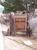
 view gallery view gallerySE18.5 km | Bicentennial Celebration in New Mexico Historical Markers Official Scenic Historical Marker posted by: Avi8torAce location: New Mexico date approved: 02/26/2008 last visited: 11/25/2020 |
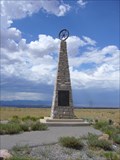
 view gallery view gallerySE18.5 km |  Bicentennial Rest Area - La Cienega, New Mexico Bicentennial Rest Area - La Cienega, New Mexico
in Spirit of '76 This is a bicentennial rest area South West of Sante Fe. posted by: GT.US location: New Mexico date approved: 03/01/2010 last visited: 11/25/2020 |
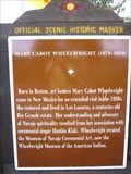 view gallery view gallerySE18.5 km | Mary Cabot Wheelwright (1878-1958) in New Mexico Historical Markers A New Mexico Historic Women Marker at the La Bajada Rest Area on I-25. posted by: leadhiker location: New Mexico date approved: 10/13/2011 last visited: 11/25/2020 |
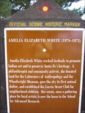 view gallery view gallerySE18.5 km | Amelia Elizabeth White (1878-1972) in New Mexico Historical Markers A New Mexico Historic Women Marker at the La Bajada Rest Area on I-25. posted by: leadhiker location: New Mexico date approved: 10/13/2011 last visited: 11/25/2020 |
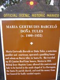 view gallery view gallerySE18.5 km | Maria Gertrudis Barceló - Doña Tules (c. 1800-1852) in New Mexico Historical Markers A New Mexico Historic Women Marker at the La Bajada Rest Area on I-25. posted by: leadhiker location: New Mexico date approved: 10/13/2011 last visited: 11/25/2020 |
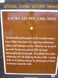 view gallery view gallerySE18.5 km | Laura Gilpin (1891- 1979) in New Mexico Historical Markers A New Mexico Historic Women Marker at the La Bajada Rest Area on I-25. posted by: leadhiker location: New Mexico date approved: 10/13/2011 last visited: 11/25/2020 |
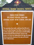 view gallery view gallerySE18.5 km | Three Wise Women in New Mexico Historical Markers A New Mexico Historic Women Marker at the north-bound La Bajada Rest Area on I-25. posted by: leadhiker location: New Mexico date approved: 10/14/2011 last visited: 11/25/2020 |
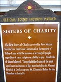 view gallery view gallerySE18.5 km | Sisters of Charity in New Mexico Historical Markers A New Mexico Historic Women Marker at the La Bajada Rest Area on I-25. posted by: leadhiker location: New Mexico date approved: 10/13/2011 last visited: 11/25/2020 |
 view gallery view gallery N20.6 km N20.6 km
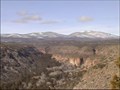
| Bandelier National Monument in National Parks of the World Bandelier National Monument is a U.S. National Monument consisting of 32,737 acres (132.48 km²) of northern New Mexico, United States. About five-sevenths of the monument has been designated a wilderness area. posted by: RakeInTheCache location: New Mexico date approved: 11/04/2006 last visited: 01/14/2023 |
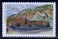 view gallery view galleryN20.8 km |  Visitor’s Center, Bandelier National Monument, New Mexico Visitor’s Center, Bandelier National Monument, New Mexico
in Philatelic Photographs Bandelier National Monument was one of sixteen parks featured on a 2016 U.S. postage stamp issue celebrating the centennial of the National Park Service. posted by: hykesj location: New Mexico date approved: 12/27/2019 last visited: never |
|